- Dry Fork (Cheat River)
-
Dry Fork River 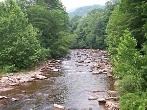 The Dry Fork near Harman
Country United States State West Virginia Counties Tucker, Randolph Tributaries - left Glady Fork, Laurel Fork, Otter Creek - right Red Creek Cities Hendricks, Harman Source - location Col between Harper and Yokum knobs, Randolph County - elevation 3,740 ft (1,140 m) - coordinates 38°44′01″N 79°38′52″W / 38.73361°N 79.64778°W Mouth Confluence with Blackwater River - location Hendricks, Tucker County - elevation 1,700 ft (518 m) - coordinates 39°04′20″N 79°37′45″W / 39.07222°N 79.62917°W Discharge for Hendricks - average 756 cu ft/s (21 m3/s) (2005)[1] 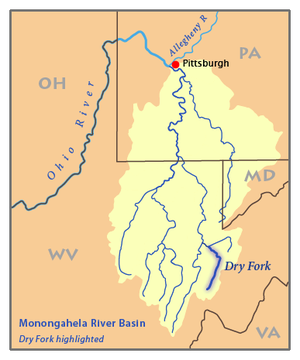 Map of the Monongahela River basin, with Dry Fork highlighted.
The Dry Fork is a 39.1-mile-long (62.9 km)[2] tributary of the Black Fork of the Cheat River in the Allegheny Mountains of eastern West Virginia in the United States. Via the Black Fork, the Cheat, and the Monongahela and Ohio rivers, it is part of the watershed of the Mississippi River. The Dry Fork flows for much of its length in the Monongahela National Forest and drains mostly rural and forested areas.[3] According to the Geographic Names Information System, it has also been known historically as Dry Run.[4] The stream's name derives from the occurrence of underground passages through which portions of the stream flow, leaving a dry streambed on the surface at times during the year.[5] (See Sinks of Gandy)
The Dry Fork rises between Rich Mountain and Little Middle Mountain in eastern Randolph County and initially flows north-northeastwardly, past the town of Harman; in Tucker County it turns to the northwest and flows to the town of Hendricks, where it meets the Blackwater River to form the Black Fork.[3]
Tributaries
Gandy Creek (which passes through a well-known cave, the "Sinks of Gandy") joins Dry Fork at the town of Gandy. In the lower part of its course the Dry Fork collects the Laurel Fork, which joins it in Randolph County, and the Glady Fork, which joins it in Tucker County.[3] Both of these are also considered principal tributaries of the Cheat River.[6] Red Creek also drains much of the Dolly Sods Wilderness area.
See also
- List of West Virginia rivers
References
- ^ United States Geological Survey (USGS), Surface Water Annual Statistics for Hendricks, WV. Average shown is for 2005, most recent for which figures are available. Retrieved March 16, 2007.
- ^ "The National Map". U.S. Geological Survey. http://viewer.nationalmap.gov/viewer/. Retrieved Feb. 17, 2011.
- ^ a b c DeLorme (1997). West Virginia Atlas & Gazetteer. Yarmouth, Maine: DeLorme. ISBN 0-89933-246-3.
- ^ U.S. Geological Survey Geographic Names Information System: Dry Fork
- ^ Kenny, Hamill (1945). West Virginia Place Names: Their Origin and Meaning, Including the Nomenclature of the Streams and Mountains. Piedmont, West Virginia: The Place Name Press. p. 215.
- ^ Julian, Norman. 2006. "Cheat River." The West Virginia Encyclopedia. Ken Sullivan, editor. Charleston, WV: West Virginia Humanities Council. ISBN 0-9778498-0-5.
Categories:- Rivers of West Virginia
- Monongahela National Forest
- Geography of Randolph County, West Virginia
- Geography of Tucker County, West Virginia


Wikimedia Foundation. 2010.