- Shavers Fork
Geobox|River
name = Shavers Fork
native_name =
other_name =
other_name1 =
image_size = 300
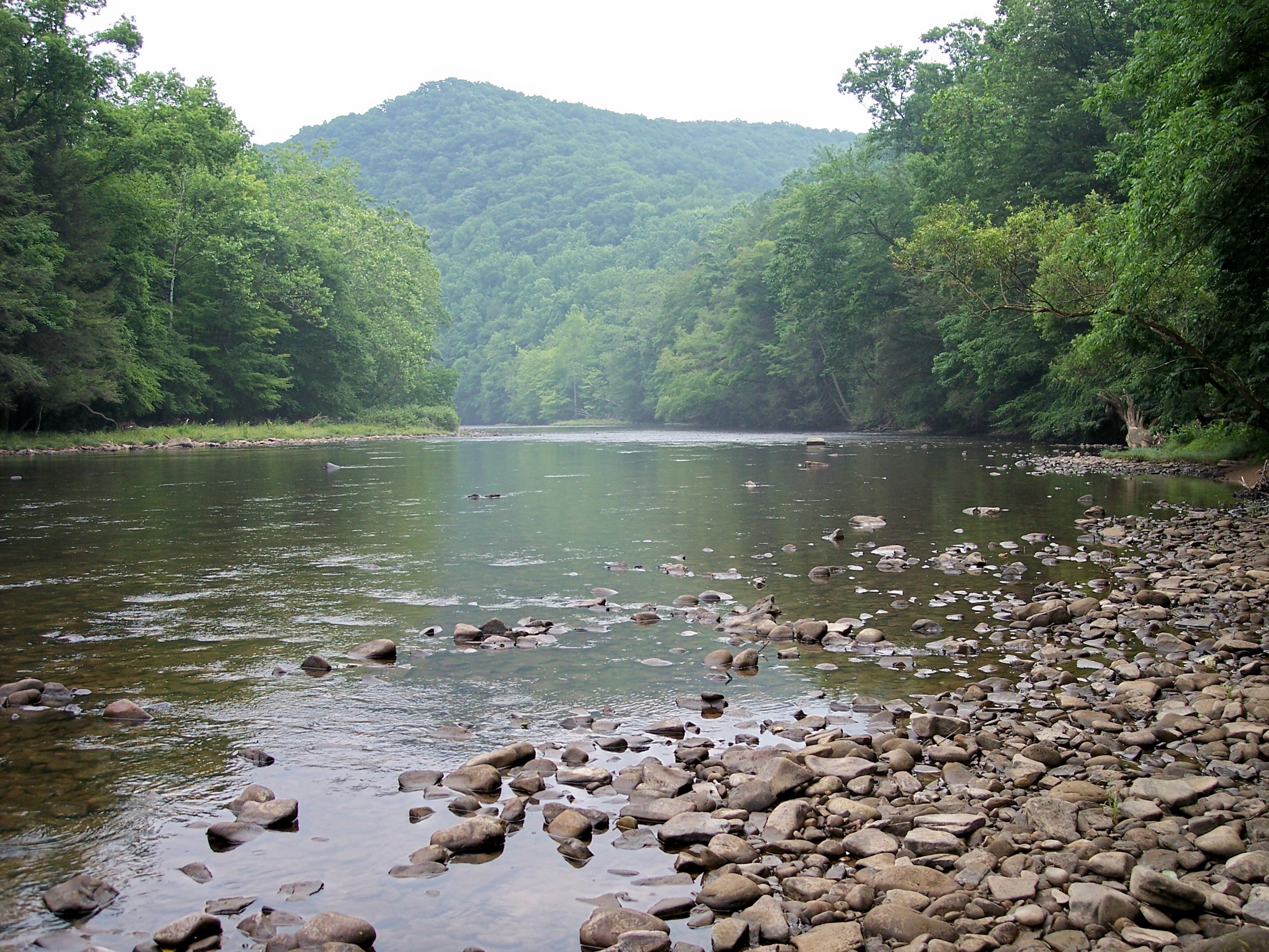
image_caption = Shavers Fork at Stuart Recreation Area in theMonongahela National Forest
country = United States
country_
state = West Virginia
state_
region_type = Counties
region = Tucker
region1 = Randolph
region2 = Pocahontas
district =
district1 =
city =
city1 =
length_imperial = 89
length_note =Godfrey, Tanya. 2006. "Shavers Fork." "The West Virginia Encyclopedia". Ken Sullivan, editor. Charleston, WV: West Virginia Humanities Council. ISBN 0-9778498-0-5.]
watershed_imperial = 214
watershed_note =
discharge_location = Bowden,West Virginia
discharge_average_imperial = 445
discharge_max_imperial = 964
discharge_max_note = (2002)
discharge_min_imperial = 99
discharge_min_note = (1976)
discharge_note = cite web
url = http://waterdata.usgs.gov/nwis/uv?03068800
title = USGS 03068800 SHAVERS FORK BELOW BOWDEN, WV
work = National Water Information System
accessdate = 2008-04-24
publisher =U.S. Geological Survey ]
discharge1_location = Cheat Bridge, WV
discharge1_average_imperial = 188
discharge1_note = cite web
url = http://waterdata.usgs.gov/nwis/uv?03067510
title = USGS 03067510 SHAVERS FORK NR CHEAT BRIDGE, WV
work = National Water Information System
accessdate = 2008-04-24
publisher =U.S. Geological Survey ]
source_name = Thorny Flat,Cheat Mountain
source_location = Pocahontas County
source_district =
source_region =
source_state = West Virginia
source_country =
source_lat_d = 38
source_lat_m = 23
source_lat_s = 44
source_lat_NS = N
source_long_d = 79
source_long_m = 59
source_long_s = 02
source_long_EW = W
source_coordinates_note = cite gnis|1552850|Shavers Fork|2004-04-24]
source_elevation_imperial = 4553
source_elevation_note = cite web
url = http://gisdata.usgs.gov/XMLWebServices/TNM_Elevation_Service.asmx/getElevation?X_Value=-79.983889&Y_Value=38.395556&Elevation_Units=FEET&Source_Layer=-1&Elevation_Only=FALSE
title = Shavers Fork Source
work = Elevation Query
accessdate = 2008-04-24
publisher =U.S. Geological Survey ]
source_length_imperial =
mouth_name = Cheat River
mouth_location = Parsons
mouth_district =
mouth_region =
mouth_state = West Virginia
mouth_country =
mouth_lat_d = 39
mouth_lat_m = 06
mouth_lat_s = 39
mouth_lat_NS = N
mouth_long_d = 79
mouth_long_m = 40
mouth_long_s = 43
mouth_long_EW = W
mouth_elevation_imperial = 1621
mouth_note =
tributary_left =
tributary_left1 =
tributary_right =
tributary_right1 =
free_name =
free_value =
map_size = 300
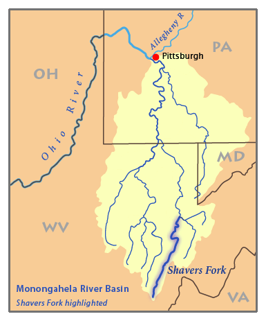
map_caption = Map of the Monongahela River basin, with Shavers Fork highlighted.Shavers Fork of
Cheat River is situated in theAllegheny Mountains of easternWest Virginia , USA. It is 88.5 mi (142.5 km) longGodfrey, Tanya. 2006. "Shavers Fork." "The West Virginia Encyclopedia". Ken Sullivan, editor. Charleston, WV: West Virginia Humanities Council. ISBN 0-9778498-0-5.] and forms the Cheat at its confluence with Black Fork at Parsons.DeLorme (1997). "West Virginia Atlas & Gazetteer". Yarmouth, Maine: DeLorme. ISBN 0-89933-246-3.] Its upper reaches are the highest river in the eastern United States. [ Bender, Steve (2002) [http://findarticles.com/p/articles/mi_qa3676/is_200204/ai_n9034585 “Cheat River: West Virginia”] "Southern Living ",Southern Progress Corporation , Spring 2002.]Geography
Shavers Fork, via the Cheat, Monongahela and Ohio Rivers, is part of the watershed of the
Mississippi River , draining an area of 214 mi² (554 km²). It flows for much of its length through theMonongahela National Forest , and drains mostlyrural andforest ed areas. 97% of the river's basin is forested, and two-thirds of it is public land.Shavers Fork rises in north-central Pocahontas County at
Thorny Flat , highest peak ofCheat Mountain (4,848 ft/1,478 m) and the site ofSnowshoe Mountain ski resort. Its headwaters flow through theghost town of Spruce. The river then flows generally north-northeastwardly through Randolph and Tucker Counties, where its valley is the trough between Cheat Mountain (to the west) andShavers Mountain (to the east). Settlements along its course include Cheat Bridge, Bemis, Bowden, and Porterwood. It ultimately joins the Black Fork at Parsons to form the Cheat at an elevation of 1621 ft (494 m).Variant names and spellings
According to the
Geographic Names Information System , Shavers Fork has also been known historically as:
*Chavers Fork
*Main Cheat River
*Shafers Fork
*Shaffers Fork of Cheat River
*Shaver's Fork
*Shavers Fork River
*Shavers Fork of Cheat Riveree also
*
List of West Virginia rivers References
External links
* [http://www.nature.org/wherewework/northamerica/states/westvirginia/preserves/art13867.html "The Nature Conservancy's" Upper Shavers Fork Preserve]

Wikimedia Foundation. 2010.