- Backbone Mountain
-
Backbone Mountain Ridge 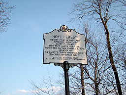 Marker at Hoye Crest, the high point of Maryland
Country United States States Maryland, West Virginia Counties Tucker WV, Preston WV, Garrett MD Range Allegheny Mountains Location Hoye Crest in Garrett County, Maryland - elevation 3,360 ft (1,024.1 m) - coordinates 39°14′14″N 79°29′09″W / 39.23722°N 79.48583°W Highest point 3.92 mi (6.31 km) west of Thomas, West Virginia - location Tucker County, West Virginia - elevation 3,684 ft (1,122.9 m) - coordinates 39°08′50″N 79°34′12″W / 39.14722°N 79.57°W Length 39 mi (63 km) [1] Topo maps USGS Mozark Mountain, Lead Mine, Davis, Table Rock, Gorman, Deer Park, Kitzmiller, Bittinger Nearest city Parsons, West Virginia 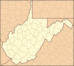
 Location of Backbone Mountain in Maryland and West Virginia
Backbone Mountain is a ridge of the Allegheny Mountains of the central Appalachian Mountain Range. It is situated in the U.S. states of West Virginia and Maryland and forms a portion of the Eastern Continental Divide. Its summit is the highest point in the state of Maryland.
Contents
Description and geography
Backbone Mountain stretches approximately 39 miles (63 km) southwest to northeast, from the Black Fork near Hambleton in Tucker County, West Virginia to the Savage River Reservoir in Garrett County, Maryland.[1]
The mountain provides a boundary between two watersheds. The headwaters of Youghiogheny River, in the watershed of the Mississippi River, lie just northwest of the mountain, whereas the headwaters of the North Branch of the Potomac River lie just south of the mountain, along the West Virginia-Maryland border.
The ridge is crossed by twice U.S. Route 219, once north of Parsons and again near Silver Lake. It is also crossed by U.S. Route 50 east of Red House, Maryland, which is marked by a Maryland State Highway Administration sign.
Notable features
Hoye-Crest
Main article: Hoye-CrestLocated just inside of Maryland along Backbone Mountain is Hoye-Crest. At an elevation of 3,360 feet (1,020 m), it is the highest point in the state of Maryland.[2] The location, named for Captain Charles Hoye, founder of the Garrett County Historical Society, has a marker and offers a view of the North Branch Potomac River valley to the east. The location is accessible via a path leading from U.S. Route 219 to the west.
Olson Observation Tower
Main article: Olson Observation TowerThe southern end of Backbone Mountain was the location of West Virginia's first fire tower.[3] The first tower was built in 1922 by the state and subsequently transferred to Monongahela National Forest. In 1963, the original tower was replaced with the one currently on-site and named after Ernest B. Olson in recognition of 28 years of service in MNF fire control and conservation programs.
While the cab of the tower is not open to the public, the 133 steps leading to it are. The tower provides spectacular views of the areas including Cheat River watershed, Parsons, Blackwater Canyon, Canaan Mountain and the Otter Creek Wilderness.
Crabtree Woods
Crabtree Woods, on the northwest slopes of Backbone Mountain, is in the Potomac-Garrett State Forest.[4] It constitutes Maryland's largest surviving remnant of old-growth forest: over 500 acres (2.0 km2) [5] of mixed Appalachian hardwoods (sugar maple, red oak, basswood and cucumber tree).[6]
See also
- List of tallest mountains of U.S. states
- Blackwater Canyon
- Monongahela National Forest
External links
- "Olson Tower". Monongahela National Forest. http://www.fs.usda.gov/wps/portal/fsinternet/!ut/p/c4/04_SB8K8xLLM9MSSzPy8xBz9CP0os3gDfxMDT8MwRydLA1cj72BTJw8jAwjQL8h2VAQAzHJMsQ!!/?ss=110921&ttype=recarea&recid=7055&actid=64&navtype=BROWSEBYSUBJECT&position=BROWSEBYSUBJECT&navid=110340000000000&pnavid=110000000000000&cid=null&pname=Monongahela+National+Forest+-+Olson+Observation+Tower. Retrieved 2011-05-08.
- "Backbone Mountain". SummitPost.org. http://www.summitpost.org/page/152048. Retrieved 2011-05-07.
References
- ^ a b "Backbone Mountain". Geographic Names Information System, U.S. Geological Survey. http://geonames.usgs.gov/pls/gnispublic/f?p=gnispq:3:::NO::P3_FID:588826. Retrieved 2008-06-01.
- ^ "Hoye-Crest Historical Marker". Maryland Historical Trust and Maryland State Highway Administration. http://en.wikipedia.org/wiki/Image:HoyeCrest.JPG. Retrieved 2008-06-02.
- ^ "Olson Observation Tower". Monongahela National Forest. http://www.fs.fed.us/r9/mnf/rec/observation_towers/olson_tower.htm. Retrieved 2008-06-02.
- ^ Maryland Native Plant Society: Crabtree Old-Growth Forest, Garrett County, Maryland
- ^ DeGroot, Bob (January 12, 2006), “Legislative Issue: Protecting Maryland's Forests and Wildlife”, The Sierra Club Maryland Chapter Newsletter Online
- ^ McCarthy, B.C. and D.R. Bailey (1996), “Composition, structure, and disturbance of Crabtree Woods: an old-growth forest of western Maryland”, Bulletin of the Torrey Botanical Club 123(4), pp. 350-365.
U.S. State Highest Natural Points Alabama • Alaska • Arizona • Arkansas • California • Colorado • Connecticut • Delaware • Florida • Georgia • Hawaii • Idaho • Illinois • Indiana • Iowa • Kansas • Kentucky • Louisiana • Maine • Maryland • Massachusetts • Michigan • Minnesota • Mississippi • Missouri • Montana • Nebraska • Nevada • New Hampshire • New Jersey • New Mexico • New York • North Carolina • North Dakota • Ohio • Oklahoma • Oregon • Pennsylvania • Rhode Island • South Carolina • South Dakota • Tennessee • Texas • Utah • Vermont • Virginia • Washington • West Virginia • Wisconsin • Wyoming
National Recreation Areas Wilderness Areas Big Draft Wilderness • Cranberry Wilderness • Dolly Sods Wilderness • Laurel Fork North Wilderness • Laurel Fork South Wilderness • Otter Creek Wilderness • Roaring Plains West Wilderness • Spice Run Wilderness
Observation Towers Lakes Lake Sherwood • Spruce Knob Lake • Summit Lake
Mountains and Summits Allegheny Front • Allegheny Mountain • Back Allegheny Mountain • Backbone Mountain • Barton Knob • Bickle Knob • Champe Rocks • Cheat Mountain • Gaudineer Knob • Mount Porte Crayon • North Fork Mountain • River Knobs • Seneca Rocks • Shavers Mountain • Spruce Knob • Spruce Mountain
Other Major Areas Blackwater Canyon • Camp Allegheny • Bear Rocks Preserve • Canaan Valley • Cheat Summit Fort • Cranberry Glades • Fernow Experimental Forest • Gaudineer Scenic Area • Germany Valley • Highland Scenic Highway • Sinks of Gandy • Smoke Hole Canyon
Rivers and Creeks US Forest ServiceCategories:- Mountains of Maryland
- Mountains of West Virginia
- Geography of Garrett County, Maryland
- Geography of Preston County, West Virginia
- Geography of Tucker County, West Virginia
- Monongahela National Forest
- Ridges of the United States


Wikimedia Foundation. 2010.