- Otter Creek Wilderness
-
Otter Creek Wilderness Part of Monongahela National Forest Wilderness Area 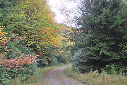 Otter Creek Trail (shown near Condon Run trailhead) runs the length of the Wilderness.
Country United States State West Virginia Counties Randolph, Tucker Coordinates 39°01′58″N 79°39′13″W / 39.03278°N 79.65361°W Highest point McGowan Mountain [1] - location northeast of Bowden - elevation 3,912 ft (1,192.4 m) [2] - coordinates 38°59′00″N 79°41′39″W / 38.9833333°N 79.69417°W Lowest point Dry Fork riverbank - location southeast of Hendricks - elevation 1,751 ft (533.7 m) [3][4] - coordinates 39°04′03″N 79°36′51″W / 39.0675°N 79.61417°W Area 20,698 acres (8,376.2 ha) [5] Established 1975 [1] Management Monongahela National Forest Owner USDA Forest Service IUCN category Ib - Wilderness Area Nearest city Elkins, West Virginia 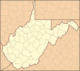
 Location of Otter Creek Wilderness in West Virginia
Website: Otter Creek Wilderness The Otter Creek Wilderness is a U.S. Wilderness area located in the Cheat-Potomac Ranger District of Monongahela National Forest in West Virginia.[5] The Wilderness sits in a bowl-shaped valley formed by Otter Creek, between McGowan Mountain and Shavers Mountain in Tucker County and Randolph County, West Virginia.[1] It is crossed by 42 miles (68 km) of hiking trails. Otter Creek Trail is the longest, at 11 miles (18 km).[6]
Contents
History
By 1914, all of the virgin forest in the Otter Creek watershed had been timbered, mostly by the Otter Creek Boom and Lumber Company, but also by the owners of several small farms and homesteads.[5] In 1917 key land purchases were made by the U.S. Forest Service as part of the formation of the national forest system. The Otter Creek area was managed as a multiple use forest, including some second growth logging, until the passage of the Eastern Wilderness Act in 1975.[7] The last private in-holding was acquired the same year.
2009 addition
The Omnibus Public Lands Management Act of 2009 added 698 acres (282 ha) to the original 20,000 acres (8,100 ha) of the Otter Creek Wilderness.[8] This addition is situated on the northern and eastern flanks of McGowan Mountain leading down to Dry Fork. It provides much of the scenic view for this popular river which contains excellent whitewater paddling and trout fishing.
References
- ^ a b c Otter Creek Wilderness page, GORP web site, accessed April 15, 2008
- ^ USGS Bowden Quad Topographic Map, as displayed on TopoQuest, accessed July 6, 2008
- ^ "Elevation for Low Point of Otter Creek Wilderness". U.S. Geological Survey. http://gisdata.usgs.gov/xmlwebservices2/elevation_service.asmx/getElevation?X_Value=-79.614167&Y_Value=39.0675&Elevation_Units=FEET&Source_Layer=-1&Elevation_Only=FALSE. Retrieved 2009-05-19.
- ^ "Otter Creek Wilderness Proposed Expansion". Monongahela National Forest. 2008-03-11. Archived from the original on 2009-05-19. http://www.webcitation.org/5gsa78lKu. Retrieved 2009-05-19.
- ^ a b c "Otter Creek Wilderness". Monongahela National Forest. http://fs.usda.gov/wps/portal/fsinternet/!ut/p/c5/04_SB8K8xLLM9MSSzPy8xBz9CP0os3gjAwhwtDDw9_AI8zPyhQoYAOUjMeXDfODy-HWHg-zDrx8kb4ADOBro-3nk56bqF-RGGGSZOCoCAPi8eX8!/dl3/d3/L2dJQSEvUUt3QS9ZQnZ3LzZfME80MEkxVkFCOTBFMktTNUJIMjAwMDAwMDA!/?navtype=BROWSEBYSUBJECT&recid=12369&actid=&navid=110000000000000&pnavid=&ss=110921&position=&ttype=recarea&pname=Monongahela%20National%20Forest%20-%20Otter%20Creek%20Wilderness. Retrieved April 13, 2010.
- ^ Otter Creek page, Wilderness.net web site, accessed April 18, 2007
- ^ Wilderness Description page, West Virginia Highlands Conservancy web site, accessed April 18, 2008
- ^ "Omnibus Public Lands Management Act of 2009". Library of Congress. http://hdl.loc.gov/loc.uscongress/legislation.111hr146. Retrieved 2009-05-14.
Further reading
- Otter Creek Wilderness at American Byways
National Recreation Areas Wilderness Areas Big Draft Wilderness • Cranberry Wilderness • Dolly Sods Wilderness • Laurel Fork North Wilderness • Laurel Fork South Wilderness • Otter Creek Wilderness • Roaring Plains West Wilderness • Spice Run Wilderness
Observation Towers Lakes Lake Sherwood • Spruce Knob Lake • Summit Lake
Mountains and Summits Allegheny Front • Allegheny Mountain • Back Allegheny Mountain • Backbone Mountain • Barton Knob • Bickle Knob • Champe Rocks • Cheat Mountain • Gaudineer Knob • Mount Porte Crayon • North Fork Mountain • River Knobs • Seneca Rocks • Shavers Mountain • Spruce Knob • Spruce Mountain
Other Major Areas Blackwater Canyon • Camp Allegheny • Bear Rocks Preserve • Canaan Valley • Cheat Summit Fort • Cranberry Glades • Fernow Experimental Forest • Gaudineer Scenic Area • Germany Valley • Highland Scenic Highway • Sinks of Gandy • Smoke Hole Canyon
Rivers and Creeks US Forest Service Categories:- IUCN Category Ib
- Monongahela National Forest
- Protected areas of Randolph County, West Virginia
- Protected areas of Tucker County, West Virginia
- Wilderness Areas of West Virginia


Wikimedia Foundation. 2010.