- Blackwater Falls State Park
Geobox|Protected Area
name = Blackwater Falls State Park
native_name =
other_name =
other_name1 =
category = West Virginia State Park
iucn_category =
image_caption = Blackwater Falls
etymology_type =
etymology =
country = United States
country_
state = West Virginia
state_
region_type = County
region = Tucker
district_type =
district =
district1 =
district2 =
city =
city1 =
location =
lat_d = 39
lat_m = 06
lat_s = 32
lat_NS = N
long_d = 79
long_m = 29
long_s = 46
long_EW = W
elevation_imperial = 2897
elevation_round = 1
area_unit = acre
area_imperial = 2358
area_round = 1
area_note = [http://www.wvstateparks.com/recreation/WVSP_facilities_grid.PDF West Virginia State Parks Facilities Grid, accessed March 29, 2008] ]
area1_imperial =
area1_type =
length_imperial =
length_orientation =
width_imperial =
width_orientation =
highest =
highest location =
highest_lat_d =
highest_lat_m =
highest_lat_s =
highest_lat_NS =
highest_long_d =
highest_long_m =
highest_long_s =
highest_long_EW =
highest_elevation_imperial =
lowest =
lowest_location =
lowest_lat_d =
lowest_lat_m =
lowest_lat_s =
lowest_lat_NS =
lowest_long_d =
lowest_long_m =
lowest_long_s =
lowest_long_EW =
lowest_elevation_imperial =
biome =
biome_share =
biome1 =
biome1_share =
geology =
geology1 =
plant =
plant1 =
animal =
animal1 =
established_type = Established
established = 1937
established_note = cite book|title=Where People and Nature Meet: A History of the West Virginia State Parks|publisher=Pictorial Histories Publishing Company|location=Charleston,West Virginia |date=April 1988|isbn=0-933126-91-3]
established1_type = Land leased
established1 = 1934
established1_note =
established2_type = Land acquired
established2 =1953-10-05
established2_note =
owner =West Virginia Division of Natural Resources
management_location =
management_lat_d =
management_lat_m =
management_lat_s =
management_lat_NS =
management_long_d =
management_long_m =
management_long_s =
management_long_EW =
management_elevation =
visitation =
visitation_year =
free_type = Nearest city
free_label = Nearest city
free = Davis,West Virginia
free1_type =
free1 =

map_caption = Location of Blackwater Falls State Park in West Virginia
map_locator = West Virginia
map_first =
website = [http://www.blackwaterfalls.com Blackwater Falls State Park]Blackwater Falls State Park is located in the
Allegheny Mountains ofTucker County, West Virginia , USA. The centerpiece of the Park is Blackwater Falls, a convert|62|ft|m|sing=on cascade where the Blackwater River leaves its leisurely course inCanaan Valley and enters ruggedBlackwater Canyon . It is among the most photographed venues in the state and appears on calendars, stationary, advertisements of all kinds and, most famously, on jigsaw puzzles. The River is named for itstannic acid -darkened water.Geography
Blackwater Falls State Park is located about two miles (3 km) southeast of the town of Davis. It protects convert|2358|acre of
red spruce andeastern hemlock upland forest. (Other important tree species in the Park includeyellow birch ,American beech ,red maple andblack cherry .)The Falls
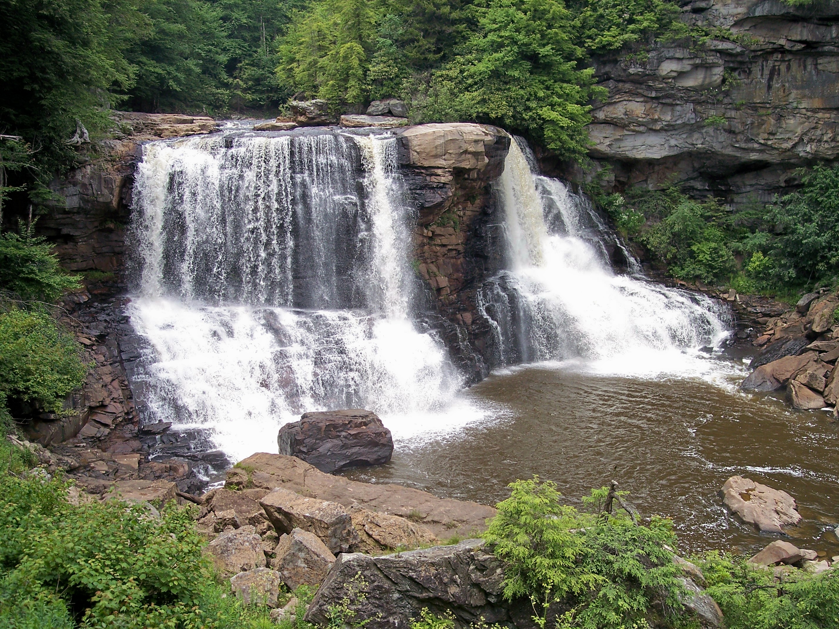
The "Great Falls" of Blackwater River drop about convert|62|ft|m at the head of Blackwater Canyon. The major ledge is composed of
Connoquenessing sandstone of the MiddlePottsville Formation . The Falls are usually cited as the highest above ground falls (there are higher cave falls) in the state [The height of the Falls is between 57 and convert|63|ft|m, depending on how it is measured. Adams, Kevin (2002), "Waterfalls of Virginia and West Virginia:A Hiking and Photography Guide",Birmingham, Alabama :Menasha Ridge Press , pg 217.] . A rocky prominence near the center of the Falls divides its waters into a distinctive formation, rendering its images instantly recognizable. In winter, the Falls often ice over completely. A broad trail descends about convert|320|ft|m from the Falls parking lot to a wooden walkway and overlook, while a much steeper trail extends beyond to the basin below the Falls. On the opposite (west) side of the river, a longer trail ("Gentle Trail") also accesses the Falls from a higher vantage point.Other park trails and falls
A nature trail (wheelchair-accessible) near the park lodge leads to the more distant Lindy Point overlook, affording an excellent view south into the Canyon. There are several other smaller falls within the park. These chutes, cascades, and overhanging ledges on Falls Run (multi-ledge drop, 30 feet), Shays Run (Falls of Elakala; 40 feet), and Pendleton Run (Falls of Pendleton; convert|20|ft|m plus cascades above and below) are accessible by trail.
History
The name of the first white explorer to stumble upon Blackwater Falls is not known. There was an oral tradition that it was the early hunter/explorer of the Potomac and
Youghiogheny River watershedsMeshach Browning (1781-1859), but while this is plausible there is no documentary evidence for it [Fansler, Homer Floyd (1962), "History of Tucker County, West Virginia",Parsons, West Virginia :McClain Printing Company , pg 596, n. 850] .Travel writer
Philip Pendleton Kennedy described the Blackwater Canyon for a popular readership in 1853, but somehow managed to miss the Falls [Kennedy, Philip Pendleton, "The Blackwater Chronicle, A Narrative of an Expedition into the Land of Canaan in Randolph County, Virginia",Redfield, New York , 1853.] . The same year however, his companion and cousin, the illustratorDavid Hunter Strother (“Porte Crayon”), published “The Virginia Canaan” about his adventures in the Blackwater Country and the Falls entered the literature for the first time [Strother, David Hunter, "The Virginia Canaan", "Harper's New Monthly Magazine ", December, 1853. It is probable that Strother was the discoverer of nearby Douglas Falls (at the head of the side canyon containing the North Fork Blackwater River), mistaking it for a time for the "Great Falls" itself. He later realized and corrected his mistake.] . Strother also published a more lengthy description of his June 1852 visit in an article called “The Mountains” ["Harper's New Monthly Magazine ", 10 installments, April, 1872 to September, 1875.] . The Dobbin House was built near the Falls in 1858 and provided a popular lodge for visitors to the Falls during the 1860s and ‘70s [Fansler, "Op. cit.", pg 596-597] . A published account of a May 1879 visit to the Falls by recreationalists [Davis, Rebecca Harding (1880), "By-Paths in The Mountains", "Harper's New Monthly Magazine ", July 1880.] further popularized the site. At least one death has occurred (1933) when a local was accidentally washed over the Falls during a flood [Fansler, "Op. cit.", pg 598] .Beginning in the early 1930s, various leases and donations to the state from the West Virginia Power and Transmission Company (WVPTC), later called Allegheny Power Systems, which then owned much of Blackwater Canyon, protected and facilitated tourism at the Falls. The first of these (1934) resulted in establishment and maintenance, by the West Virginia State Forest and Park Commission, of a convert|446|acre|km2 scenic overlook at the head of the Canyon which included the celebrated Falls itself. [Fansler, "Op. cit.", pg 597] . The park was formally established in 1937. Additional donations of land in 1953 and 1955 by the WVPTC, convert|489|acre|km2|1, and by the
U.S. Forest Service , convert|744|acre|km2|1, in 1957, brought the total to some convert|1679|acre|km2.The Park was day-use only until the mid-1950s. The years 1955 and ’56, however, saw several improvements to buildings and grounds including construction of 25 cabins, a dammed fishing/skating lake, and a 55 room lodge dubbed “The Lodge in the Sky” (since the park is the highest in the state) which was opened and dedicated in 1957. Annual visitors numbered 240,000 (over 18,000 of them overnighters) by 1960 [Fansler, "Op. cit.", pg 598] .
In May 2000, West Virginia Governor
Cecil Underwood purchased 25 acres of Blackwater Canyon for $50,000 an acre and added it to Blackwater Falls State Park.Allegheny Wood Products , the timber company that owns about half of the Blackwater Canyon today, donated an additional convert|100|acre|km2. In January 2002, GovernorBob Wise bought an additional convert|500|acre|km2 along the River upstream of the Falls from Allegheny Power and added them to the Park.Fact|date=July 2008Amenities and recreation
* Park Lodge with 54 guest rooms
* 26 cabins
* Campground with 65 campsites (30 have electrical hookup)
* Restaurant
*Mountain biking
* Mountain bike rentals in the summer
*Cross-country skiing
* Cross-country ski rentals in the winter
*Hiking
*Fishing in Pendleton Lake and the Blackwater River
* Horseback and pony ridesAccessibility
Accessibility for thedisable d was assessed byWest Virginia University . While the park lodge is generally accessible, the 2005 assessment indicated some issues with telephone volume control, the height of door knobs, and excessive slope of certain ramps. [ [http://www.cedwvu.org/programs/realchoice/recreation/ "Guide to Accessible Recreation and Travel in WV", WVU Center for Excellence in Disabilities web site, accessed July 31, 2006] ]ee also
*
List of West Virginia state parks References
Citations
Other sources
*Fedorko, N., 1994, "Bedrock Geology Map of Blackwater Falls", 7.5’ Quadrangle:
West Virginia Geological and Economic Survey , Open File Geological Map OF-9405.*Ludlum, J.C., and Arkle, Jr., T., 1971, "Blackwater Falls State Park and Canaan Valley State Park: Resources, Geology and Recreation", West Virginia Geological and Economic Survey, State Park Series Bulletin 6, 60 p.
External links
* [http://www.blackwaterfalls.com// Official Site]
** [http://www.blackwaterfalls.com//blackwaterparkmap.pdf Blackwater Falls State Park Map & Trail Guide]

Wikimedia Foundation. 2010.