- Cass Scenic Railroad State Park
Geobox|Protected Area
name = Cass Scenic Railroad State Park
native_name =
other_name =
other_name1 =
category = West Virginia State Park
iucn_category =
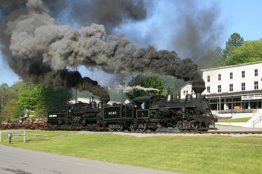
image_caption = Cass Scenic Railroad Heisler #6 along with Shay #11 lead a loaded log train down the formerC&O Greenbrier Division mainline.
etymology_type =
etymology =
country = United States
country_
state = West Virginia
state_
region_type = County
region = Pocahontas
district_type =
district =
district1 =
district2 =
city =
city1 =
location =
lat_d = 38
lat_m = 23
lat_s = 48
lat_NS = N
long_d = 79
long_m = 54
long_s = 53
long_EW = W
elevation_imperial = 2438
elevation_round = 1
area_unit = acre
area_imperial = 940
area_round = 1
area_note = [http://www.wvstateparks.com/recreation/WVSP_facilities_grid.PDF West Virginia State Parks Facilities Grid, accessed March 29, 2008] ]
area1_imperial =
area1_type =
length_imperial =
length_orientation =
width_imperial =
width_orientation =
highest =
highest location =
highest_lat_d =
highest_lat_m =
highest_lat_s =
highest_lat_NS =
highest_long_d =
highest_long_m =
highest_long_s =
highest_long_EW =
highest_elevation_imperial =
lowest =
lowest_location =
lowest_lat_d =
lowest_lat_m =
lowest_lat_s =
lowest_lat_NS =
lowest_long_d =
lowest_long_m =
lowest_long_s =
lowest_long_EW =
lowest_elevation_imperial =
biome =
biome_share =
biome1 =
biome1_share =
geology =
geology1 =
plant =
plant1 =
animal =
animal1 =
established_type = Established
established =1961-03-07
established_note = cite book|title=Where People and Nature Meet: A History of the West Virginia State Parks|publisher=Pictorial Histories Publishing Company|location=Charleston,West Virginia |date=April 1988|isbn=0-933126-91-3]
established1_type = Acquired
established1 = 1962
established1_note =
established2_type = Opened
established2 =1963-06-15
established1_note =
owner =West Virginia Division of Natural Resources
management_location =
management_lat_d =
management_lat_m =
management_lat_s =
management_lat_NS =
management_long_d =
management_long_m =
management_long_s =
management_long_EW =
management_elevation =
visitation =
visitation_year =
free_type = Nearest city
free_label = Nearest city
free = Cass,West Virginia
free1_type =
free1 =

map_caption = Location of Cass Scenic Railroad State Park in West Virginia
map_locator = West Virginia
map_first =
website = [http://www.cassrailroad.com Cass Scenic Railroad State Park]Cass Scenic Railroad State Park is a State Park located in Cass, Pocahontas County,
West Virginia .It consists of the Cass Scenic Railroad, an convert|11|mi|adj=on long heritage railroad that is owned by the state of West Virginia. The park also includes the former
company town of Cass and a portion of the summit ofBald Knob , highest point onBack Allegheny Mountain .History
Founded in 1901 by the
West Virginia Pulp and Paper Company (nowMeadWestvaco ), Cass was built as acompany town to serve the needs of the men who worked in the nearby mountains cuttingspruce and hemlock for theWest Virginia Spruce Lumber Company , a subsidiary of WVP&P. At one time, thesawmill at Cass was the largest double-band sawmill in the world. It processed an estimated 1.25 billion board feet (2,900,000 m³) of lumber during its lifetime.In the 1940s, WVP&P sold the Cass operation to
Mower Lumber Company , which operated the line until 1960, cutting second-growth timber offCheat Mountain . The mill and railroad were shut down by Mower in 1960, due to rapid decline of the timber industry in the region.Following the 1960 closure, the rail line and all equipment and rolling stock were due to be scrapped, but
Pennsylvania railfan Russell Baum convinced the West Virginia state legislature to make the Cass Railroad astate park . In 1963, the first tourist excursion train left the Cass depot for Whittaker Station (four miles up the line).Shay locomotives
Ephraim Shay (1839-1916), has been credited as a schoolteacher, physician, civil engineer, logger, merchant, railway owner, and inventor. He lived in Michigan, and became a logger in the 1860s.While a logger he wanted to find a new way to get logs to the mill, besides floating them on a river. He then built his own tramway in 1875, on 26 in. track, and wooden ties. This was very efficient and enabled him to beat his competitors because he saved so much money with the tram.
Two years would pass before he would invent the Shay Locomotive. In about 1877 he developed the idea of having an engine sit on a flat car with a boiler, gears, and trucks that could pivot. The first Shay only had two cylinders and operated through a series of gears over the inside portion of the rear truck. It did not take long for this idea to become popular.
When
Lima Locomotive Works received the Shay idea it was not impressed, but a man by the name of John Carnes influenced the company to take the idea and expand upon it. What resulted was the classic Shay design we see today.During its lifetime, Lima Locomotive Works manufactured nearly every Shay, including the last and largest Shay Western Maryland Shay #6, which is still in operation at Cass.
Current operations
Today, riding on historic converted log cars, pushed along by a powerful geared logging locomotive, you can take a step back into time. Traveling on convert|11|mi of track laid in 1901 by immigrant workers, you will traverse the steep grades of
Back Allegheny Mountain .The railroad owns eight Shay Locomotives, one
Heisler locomotive , and oneClimax locomotive , which is being restored by volunteers of theMountain State Railroad and Logging Historical Association . The Heisler and the Climax, both made inPennsylvania , were competition to Shay's geared locomotive design.Three trips are available: a two-hour round trip to Whittaker Station, a five-hour round trip to the abandoned site of the ghost town of Spruce (once the coldest and highest town east of the
Rockies ), and a five-hour round trip toBald Knob , the third highest point in the state.Former company houses have been refurbished and are available for rent through Cass Scenic Railroad State Park. A small cabin on Bald Knob is also available for rent, and private cabooses can be reserved as well.
Town and shop tours are available daily to visitors who would like to learn more about the town and its lumber industry, and see how the rare geared locomotives are maintained by the Cass shop crew. A tour of a recreated logging camp is available at Whittaker.
Photo gallery
ee also
*
List of heritage railroads in the United States
*List of West Virginia state parks
*Bald Knob
*Leatherbark Run External links
* [http://www.cassrailroad.com Cass Scenic Railroad State Park website]
* [http://msrlha.org/ Mountain State Railroad & Logging Historical Association web site]
* [http://www.gottrains.com/cassrailroad WV Railfan website]
* [http://www.steamphotos.com/gallery/5021935_Ewvcr Cass Scenic Railroad photos]References
* Withers, Bob (
August 25 2005 ), " [http://www.herald-dispatch.com/2005/August/25/ETcass.htm Cass railroad line to mark birthday] ". RetrievedAugust 25 2005 .* Roy B. Clarkson (1990), On Beyond Leatherbark

Wikimedia Foundation. 2010.