- North Fork Feather River
-
North Fork Feather River River  Milsap Bar crossing on the North Fork Feather River.[2]
Country United States State California Region North Fork Feather Watershed
1,090 sq mi (2,800 km2),[1] including the
West Fork but not East Branch WatershedSource confluence Rice Creek & South Arm Rice Creek - location Feather River Meadows[citation needed] Mouth Lake Oroville, North ArmA Length 70 mi (113 km) Basin 2,100 sq mi (5,439 km2) [1] Discharge for mouth at north arm, Lake Oroville; max and min at Pulga - average 2,930 cu ft/s (83 m3/s) [2] - max 105,400 cu ft/s (2,985 m3/s) - min 5.4 cu ft/s (0 m3/s) GNIS code
Huc264163[3]
18020121APrior to Oroville Dam construction, the North Fork flowed to its former mouth[3] in the current lake's Main Basin.[4] The North Fork Feather River is a watercourse of the northern Sierra Nevada in the U.S. state of California. It flows generally southwards from its headwaters near Lassen Peak to Lake Oroville, a reservoir formed by Oroville Dam in the foothills of the Sierra, where it runs into the Feather River. The river drains about 2,100 square miles (5,400 km2) of the western slope of the Sierras. By discharge, it is the largest tributary of the Feather.
It rises at the confluence of Rice Creek and a smaller unnamed stream in the southern part of the Lassen Volcanic National Park. The river flows east, receiving Warner Creek from the left, and passes the town of Chester. It then empties into Lake Almanor, which is formed by the Canyon Dam. After leaving the dam the river cuts south into a gorge, and turns southwest to receive Butt Creek from the right. The East Branch North Fork Feather River, the North Fork's largest tributary, comes in from the left near Belden, where the river is impounded again at the Rock Creek Dam. It then flows southwards into the north arm of Lake Oroville.
The fork's portion of the Feather River Canyon is notable as part of the Feather River Route, and the railroad's North Fork Bridge near the river's mouth is the longest reinforced concrete bridge in the US.[5] Reservoirs on the North Fork include those of the 1962 Rock Creek-Cresta Hydroelectric Project.
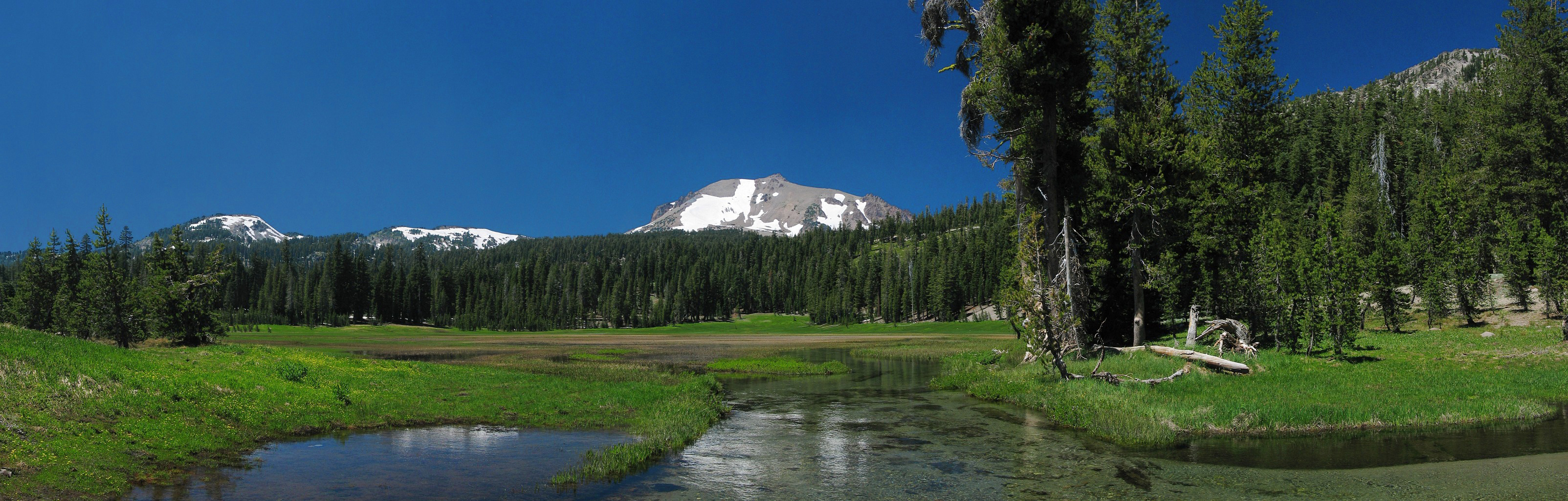
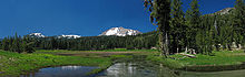 Kings Creek (foreground) headwaters flow >11 mi (18 km) from the SE slope of Lassen Peak (background), >7 mi (11 km) in Warner Creek, and >63 mi (101 km) in the North Fork to Lake Oroville's northern arm.
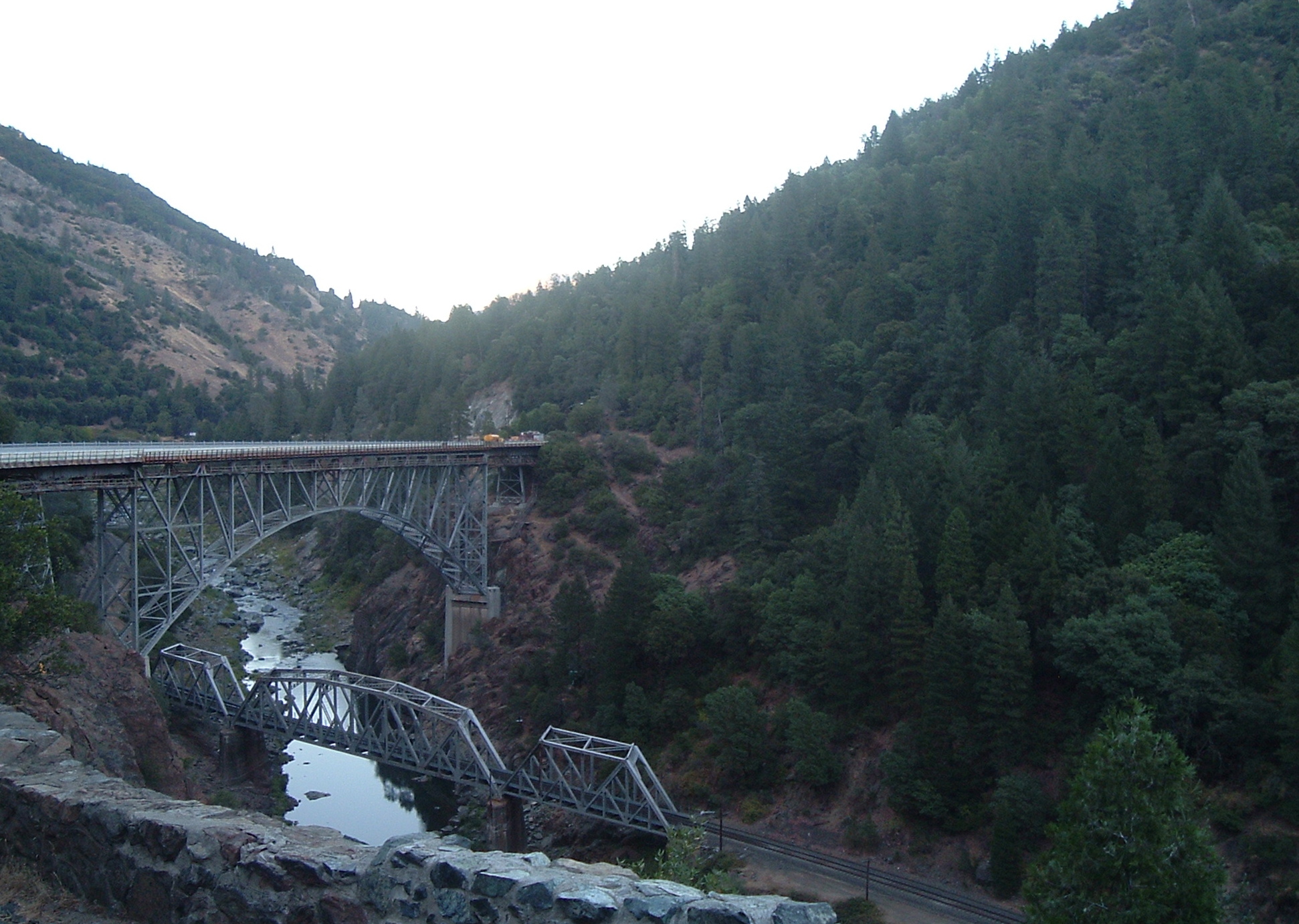
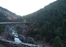 A railroad trestle and CA 70 over the North Fork.
North Fork Feather Watershed
The North Fork Feather Watershed (USGS Huc 18020121) extends from the North Fork headwaters south-southwest to the [http://cfpub.epa.gov/surf/huc.cfm?huc_code=18020106 Lower Feather Watershed. The headwaters are in the Shasta Cascades and the northern Sierras along the Pit River and Eagle-Honey watersheds. The drainage divide for the headwaters begins in Shasta County at the Lassen Peak quadruple watershed point of East Sulpher Creek (Mill-Big Chico), Manzanita Creek (Upper Cow-Battle watershed), Lost Creek (Lower Pit River), and Kings Creek (North Fork Feather). The headwater divide extends in an arc east to Lassen County, then to the Great Basin Divide triple point of the Feather, Pit, and Susan Rivers. The divide arcs southeast to Pegleg Mountain and along 13 mi (21 km) of the Sierra Crest to the triple point with the East Branch North Fork Feather River on the east slope of Indicator Peak (40°00′43″N 120°11′15″W / 40.012069°N 120.187554°W).
For a list of Sierra Nevada (U.S.) headwater creeks that drain to the North Fork, see Sierra Crest.Downstream of Shasta and Lassen counties, the majority of the North Fork Feather Watershed area is in Plumas County. The west divide of the watershed is along the Mill-Big Chico Watershed, southward to the West Branch Feather River triple point. The southeast divide of the North Fork Feather Watershed is the watershed of the East Branch to the triple point with the Middle Fork Feather River.
The lowest elevations of the North Fork Feather Watershed are in Butte County, with the emergency weir crest at 901 ft (275 m) and, at average storage capacity, the Lake Oroville level of 812 ft (247 m) .[6]
North Fork Feather River course,
including associated Lake Oroville points
This list is incomplete; you can help by expanding it.description coordinates headpoint summit SSE of Mount Helen 40°27′39″N 121°29′53″W / 40.460728°N 121.498103°W Rice Creek confluence, headwaters w/ Rice Cr 40°27′19″N 121°29′08″W / 40.455242°N 121.485572°W inflow to Crumbaugh Lake 40.447829 121.488361 border, Shasta/Plumas counties [specify] border, Stump Ranch Marsh Area [specify] confluence, South Arm Rice Creek 40°21′47″N 121°27′5″W / 40.36306°N 121.45139°W North Fork source, North Fork confluence, flow from Buzzard Sprs 40.354884 121.366396 confluence, Warner Creek 40.333133 121.306529 diversion channel W of Lake Almanor 40.302538 121.263914 road, CA 36 N of Chester 40.310753 121.228638 inflow to Lake Almanor 40.303225 121.212373 Canyon Dam 40.174578 121.087017 confluence, Bear Creek 40.107487 121.080408 dam, Belden ForeBay 40.076167 121.160789 confluence, Mosquito Creek 40.060731 121.200657 North Fork in
Feather River
Canyon[5]confluence, East Branch 40°00′51″N 121°13′33″W / 40.014074°N 121.225934°W confluence, Indian Creek 40.005068 121.264 dam, Rock Creek Reservoir 39.986919 121.28314 confluence, Rock Creek 39.899959 121.359487 confluence, Jackass Creek 39.937283 121.316013 road, Rock Creek Camp 39.925535 121.316013 road, CA 70 39.918031 121.321507 confluence, Bucks Creek 39.91418 121.326742 dam, Cresta Reservoir 39.876118 121.373477 confluence, Mill Creek 39.805008 121.440425 confluence, Flea Valley Creek 39.802107 121.446948 North Fork road, 1932 arch bridge (CA 70) 39.79482 121.451669 railroad, trestles S of CA 70 39.7948 121.451669 dam, Poe Reservoir [specify] border, Plumas/Butte counties [specify] mouth, North Fork (912 ft elevation)[3] 39°43′27″N 121°28′19″W / 39.72417°N 121.47194°W Lake Oroville,
North Armrailroad, 1962 North Fork Bridge 39.716529 121.470551 confluence, Rock Creek 39.716034 121.455402 border, Lassen NF 39.71336 121.468663 confluence, Chino Creek 39.719005 121.422701 confluence, Mosquito Creek 39.69705 121.406007 confluence, W of Stephens Ridge 39.688101 121.400127 confluences, Berry & Frazier creeks 39.670166 121.431456 confluence, West Arm 39.666499 121.496773 former town, Big Ripple 39°37′38″N 121°29′33″W / 39.62722°N 121.4925°W former town, Bloomer 39°37′28″N 121°29′29″W / 39.62444°N 121.49139°W mouth, lower North Arm 39°34′43″N 121°28′19″W / 39.57857°N 121.471882°W Lake Oroville,
Main Basininflow, lake's Main Basin[4] landing area for seaplane base 39°33′59″N 121°28′07″W / 39.5662750°N 121.4685789°W former town, Bidwell 39°33′25″N 121°27′56″W / 39.55694°N 121.46556°W former mouth,A North F w/ Feather R 39°33′20″N 121°28′0″W / 39.55556°N 121.466667°W former town, Land 39°33′13″N 121°28′04″W / 39.55361°N 121.46778°W) intake (main), Hyatt powerplant Oroville Dam road on crest (900 ft elevation)[3] 39°32′20″N 121°29′08″W / 39.5387752°N 121.4855237°W downstream dam face (702 ft) 39°32′06″N 121°28′58″W / 39.5348863°N 121.4827459°W diversion, Palermo Canal (505 ft) 39°31′59″N 121°28′58″W / 39.532942°N 121.482825°W road, Oro Powerhouse (360 ft) 39°32′05″N 121°29′10″W / 39.534696°N 121.486216°W Feather River source, downstream of dam[4] 39°32′1.59″N 121°29′13.88″W / 39.533775°N 121.4871889°W former community, Quartz 39°31′58″N 121°29′54″W / 39.5326641°N 121.4983018°W confluence, Oroville Spillway[7] 39°32′08″N 121°30′06″W / 39.5356933°N 121.5016958°W For river points downstream of the spillway confluence (e.g., the Oroville Wildlife Area border), see Feather River.References
- ^ a b "Boundary Descriptions and Names of Regions, Subregions, Accounting Units and Cataloging Units". USGS.gov. http://water.usgs.gov/GIS/huc_name.html. Retrieved 2010-08-22.
- ^ Wills, Leah. "Upper Feather River Integrated Regional Water Management Plan". Plumas County. http://water.lgc.org/water-workshops/upper-sacramento-valley/Upper_Feather_Wills.pdf. Retrieved 4 August 2010.
- ^ a b c d "Query Form For The United States And Its Territories". U.S. Board on Geographic Names. http://geonames.usgs.gov/pls/gnispublic. Retrieved 2010-07-30.
- "North Fork Feather River (GNIS code 264163)". Geographic Names Information System, U.S. Geological Survey. http://geonames.usgs.gov/pls/gnispublic/f?p=gnispq:3:::NO::P3_FID:264163. Retrieved 2010-09-14. "Mouth formerly located at 393320N1212800W, now inundated by Lake Oroville. (US-T121) See Rice Creek, 1927 Board on Geographic Names (BGN) changed name and application of Rice Creek. South Arm Rice Creek and Rice Creek join to form North Fork Feather River (BGN 1950). Current maps, 1995, are mislabelled for South Arm, North Arm Rice Creek, Rice Creek and North Fork Feather River."
- "Palermo Canal (GNIS code 230252)". Geographic Names Information System, U.S. Geological Survey. http://geonames.usgs.gov/pls/gnispublic/f?p=gnispq:3:::NO::P3_FID:230252. Retrieved 2010-09-15.
- "Feather River (GNIS code 223423)". Geographic Names Information System, U.S. Geological Survey. http://geonames.usgs.gov/pls/gnispublic/f?p=gnispq:3:::NO::P3_FID:223423. Retrieved 2010-09-14. NOTE: The GNIS identifies the Feather River source at 39.5337752 -121.4871904, and Google maps depicts the source coordinates at the discharge flow point, downstream of the Oroville Dam. The National Elevation Dataset lists elevation of the source coordinates as 247.69853106321 ft)
- Lake Oroville (GNIS code 264404) NOTE: The GNIS page identifies the lake elevation as "935 ft", but the maximum water level at the Oroville Dam is 900 ft
- ^ a b c "Section 2: Proposed Action and Alternatives". Final Environmental Impact Statement for the Oroville Facilities Project. Federal Energy Regulatory Commission. p. 17. http://www.buttecounty.net/Administration/Projects/~/media/County%20Files/AdminOffice/Public%20Internet/Lake%20Oroville%20Facilities%20Project/Final%20FEIS/Section%202%20FEIS.ashx. Retrieved 2010-09-15.
- ^ a b Oxlade, John (31 December 2003). "Out-n-About - The Feather River Canyon, California, USA". WorldRailFans.info. http://www.worldrailfans.info/Articles/US/FeatherRiverCanyon.shtml. Retrieved 2010-09-11. "the actual "canyon" portion petween Pulga and Keddie is only approx. 42 miles"
- ^ "Oroville Dam (ORO)". http://cdec.water.ca.gov/cgi-progs/queryDaily?s=ORO&d=&span=1year. Retrieved 2010-09-15. NOTE: The 2010 measurements closest to average capacity (2,332,203 acre feet (2.876730 km3)) were 2,331,494 acre feet (2.875856 km3) & 2,342,112 acre feet (2.888953 km3)
- ^ "Oroville Dam". UCDavis.edu. http://cee.engr.ucdavis.edu/faculty/lund/dams/Oroville/OrovilleDam.html. Retrieved 2010-09-15. "Oroville Spillway ... gated flood control outlet and emergency weir"
Categories:- Tributaries of the Feather River
- Rivers of Plumas County, California

Wikimedia Foundation. 2010.