- Middle Fork Feather River
-
Middle Fork Feather River El Rio de las Plumas[1] River 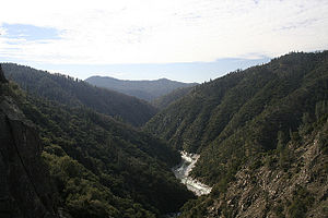 Middle Fork Feather River downstream of the confluence with the Fall River, near its mouth
Name origin: "Plumas" means "feather" in Spanish Country United States State California Region Sierra Nevada Part of Feather River watershed Tributaries - left Nelson Creek, Onion Valley Creek, South Branch Middle Fork Feather River, Fall River - right Little Last Chance Creek, Bear Creek, North Fork Middle Fork Feather River Cities Beckwourth, Portola, Cromberg Source Near Beckwourth - location Sierra Valley, Plumas County - elevation 4,872 ft (1,485 m) [2] - coordinates 39°48′49″N 120°22′46″W / 39.81361°N 120.37944°W [1] Mouth Lake Oroville - location About 10 miles (16 km) northeast of Oroville, Butte County - elevation 928 ft (283 m) [1] - coordinates 39°38′29″N 121°17′11″W / 39.64139°N 121.28639°W [1] Length 98 mi (158 km), East-west Basin 1,062 sq mi (2,751 km2) [3] Discharge for Merrimac - average 1,489.5 cu ft/s (42 m3/s) [3] - max 86,200 cu ft/s (2,441 m3/s) [4]  Map of the Feather River watershed including the Middle Fork Feather
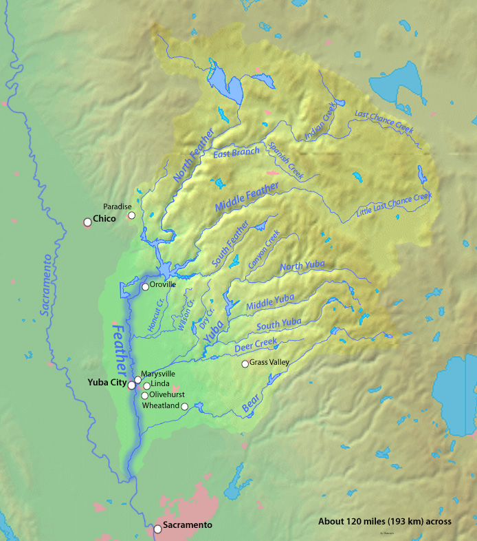
The Middle Fork Feather River is a major river in Plumas and Butte Counties in the U.S. state of California.[1] Nearly 100 miles (160 km) long, it drains about 1,062 square miles (2,750 km2)[3] of the rugged northern Sierra Nevada range.[5]
It rises near Beckwourth,[1] formed by the confluence of several streams in a large mountain-surrounded basin, the Sierra Valley called the Sierra Valley Channels.[6] The largest is Little Last Chance Creek, which flows from the northeast side of the valley. The river flows west, passing Portola and turning northwest at Clio.[6] It then enters the Plumas National Forest, turning westwards into a gorge. Nelson Creek enters from the left, then Onion Valley Creek a few miles onward.[6] Bear Creek, Willow Creek and the North Fork Middle Fork Feather River all come in from the right as the river courses west-southwest through a tight, steep canyon strewn with rapids.[6] It is then joined by the South Branch Middle Fork Feather River from the left.[6] As the river widens into an arm of Lake Oroville, a reservoir formed by the Oroville Dam, the Fall River joins from the left.[6] The reservoir is fed by the North, Middle, West and South Forks of the Feather River, which once joined in the valley to form the main Feather River. That river continues southwards to join the Sacramento River near the unincorporated community of Plumas Landing.[6]
One of the Middle Fork Feather's tributaries, the Fall River, feeds the 640-foot (200 m) Feather Falls. This waterfall is often claimed to be the third or sixth tallest in the United States;[7][8] but in reality is nowhere near the top ten in height.[9]
Wild and Scenic River
The Middle Fork is recognized by the US Government for its untamed beauty and is designated a National Wild and Scenic River for 77.6 miles of its length.[10] The 32.9 mile stretch inaccessible to roads is home to some of the best wild trout fishing in California.
Grizzly Valley
The Grizzly Valley is a 21 sq mi (54 km2) landform of the upper Middle Fork Feather watershed that receives 29-37 inches of annual precipitation.[11] The valley is the location of Lake Davis, an impoundment of Big Grizzly Creek by the 1967 Grizzly Valley Dam.[12]
References
- ^ a b c d e f "Middle Fork Feather River". Geographic Names Information System, U.S. Geological Survey. 1981-01-19. http://geonames.usgs.gov/pls/gnispublic/f?p=gnispq:3:::NO::P3_FID:263528. Retrieved 2010-09-16. NOTE For the coordinates of the Middle Fork's mouth, the USGS's National Elevation Database lists a different elevation (902.7 ft):
- "Elevation query for "X_Value=-121.2807956&Y_Value=39.6376648" (returns "902.739597430692 … FEET")". USGS Elevation Query Web Service. http://gisdata.usgs.gov/xmlwebservices2/elevation_service.asmx/getElevation?X_Value=-121.4871904&Y_Value=39.5337752&Elevation_Units=FEET&Source_Layer=-1&Elevation_Only=FALSE. Retrieved 2010-09-25.
- ^ "North Channel Little Last Chance Creek". Geographic Names Information System, U.S. Geological Survey. 1981-01-19. http://geonames.usgs.gov/pls/gnispublic/f?p=gnispq:3:::NO::P3_FID:264126. Retrieved 2010-09-16.
- ^ a b c "USGS Gage #11394500 on the Middle Fork Feather River near Merrimac, CA (Monthly Average Streamflow)". National Water Information System. U.S. Geological Survey. 1951-1986. http://waterdata.usgs.gov/nwis/monthly/?referred_module=sw&site_no=11394500&por_11394500_2=2209424,00060,2,1951-10,1986-09&format=html_table&date_format=YYYY-MM-DD&rdb_compression=file&submitted_form=parameter_selection_list. Retrieved 2010-09-16.
- ^ "USGS Gage #11394500 on the Middle Fork Feather River near Merrimac, CA (Peak Streamflow)". National Water Information System. U.S. Geological Survey. 1951-1986. http://nwis.waterdata.usgs.gov/ca/nwis/peak?site_no=11394500&agency_cd=USGS&format=html. Retrieved 2010-09-16.
- ^ George, Holly et al. (2007-03). "Upper Feather River Watershed (UFRW) Irrigation DIscharge Management Program". State Water Resources Control Board. University of California Davis. http://ucce.ucdavis.edu/files/filelibrary/1820/36228.pdf. Retrieved 2010-09-16.
- ^ a b c d e f g ACME Mapper. USGS Topo Maps for United States (Map). Cartography by United States Geological Survey. http://mapper.acme.com/. Retrieved 2010-09-16.
- ^ Soares, Marc J. (2008). 100 Classic Hikes in Northern California. The Mountaineers Books. p. 68. ISBN 1-59485-062-3.
- ^ Adkison, Ron (2000). Hiking Northern California. Globe Pequot. p. 267. ISBN 1-56044-701-X.
- ^ Swan, Bryan; Goss, Dean. "Showing all Waterfalls in USA". World Waterfall Database. http://www.world-waterfalls.com/database.php?s=T&t=G&category=country&search=USA&orderby=height%20DESC. Retrieved 2010-09-16.
- ^ "Middle Fork of the Feather Wild and Scenic River, California". rivers.gov. http://www.rivers.gov/wsr-feather.html. Retrieved 2011-11-3.
- ^ "Grizzly Valley Groundwater Basin" (pdf). 2004-02-27. http://www.water.ca.gov/pubs/groundwater/bulletin_118/basindescriptions/5-59.pdf. Retrieved 2010-09-24.
- ^ "Appendix H". EPA.gov. http://www.epa.gov/espp/litstatus/effects/redleg-frog/rotenone/appendix-h.pdf. Retrieved 2010-09-24.
Sacramento River Valley Pit River • McCloud River • Mill Creek • Deer Creek • Battle Creek •Stony Creek •Butte Creek • Feather River • Yuba River • Bear River • American River • Cache Creek • Putah CreekSan Joaquin River Valley Tulare Basin Categories:- Tributaries of the Feather River
- Rivers of Plumas County, California
- Plumas National Forest
- Sierra Nevada (U.S.)
- ^ a b c d e f "Middle Fork Feather River". Geographic Names Information System, U.S. Geological Survey. 1981-01-19. http://geonames.usgs.gov/pls/gnispublic/f?p=gnispq:3:::NO::P3_FID:263528. Retrieved 2010-09-16. NOTE For the coordinates of the Middle Fork's mouth, the USGS's National Elevation Database lists a different elevation (902.7 ft):

Wikimedia Foundation. 2010.