- North Albany, Albany, New York
-
North Albany City of Albany Neighborhood  Nipper watching over North Albany,
as seen from Loudonville RoadName origin: for originally being north
of the city of AlbanyNickname: Limerick Country United States State New York County Albany County City Albany Coordinates 42°40′01″N 73°44′13″W / 42.66694°N 73.73694°W Settled mid-1650s - Annexed to Albany 1870 Timezone Eastern Standard Time (UTC-5) - summer (DST) Eastern Daylight Time (UTC-4) Area code 518 ZIP Code 12204, 12207 
 Location of North Albany within the state of New York
North Albany is a neighborhood in the city of Albany, New York, originally a hamlet in the town of Watervliet. First settled in the mid-1600s by the Patroon of Rensselaerswyck and his tenants. Due to the Erie Canal being constructed through here in 1825 North Albany saw immense growth with the Albany Lumber District and an influx of Irish lending the area the name of Limerick. Home to many historic warehouses and row houses, North Albany continues to be the most important industrial neighborhood in Albany. Recent efforts have begun to gentrify the neighborhood adapting heavy industry/warehouse use to artistic and entertainment venues, such as a German beer garden, live music venues, and arts and crafts marketplaces.
Contents
History
The area of North Albany was originally woodland and farmland as part of the patroonship of Rensselaerswyck, a feudal land patent covering present-day Albany and Rensselaer counties. In 1654 Barent Pietersen Coeymans and Teunis Cornelissen van der Poel ( also known as Teunis Cornelissen Spitsenberch, or Spitsbergen) rented a mill along the Patroon Creek from the patroon,[1] and in 1666 Patroon Jeremias van Rensselaer built a house and associated buildings such as a mill and barn also along the Patroon Creek.[2] This area north of the original city limits of Albany as delineated by the Dongan Charter was referred to as the colonie.
In 1825 the Erie Canal was built linking Albany to Buffalo on Lake Erie. Locks 1 and 2 were located in North Albany.[2] The canal led to the establishment of the Albany Lumber District, the future lumber district at this time being owned by the Patroon Stephen Van Rensselaer and his brother William, and consisting of mostly vegetable gardens that paid little in the way of rent. The Patroon was soon approached about building slips off the canal for the use of the lumber industry in return for a more ample amount of rent.[3] For about a quarter century in the middle of the 19th century the Albany lumber district was considered the largest white pine wholesale market,[4] and by the 1870s Albany was the largest lumber district in the United States by value, though by that time it had recently been outstripped in feet sold by Chicago.[5] Also due to the canal's influence factories began to locate in North Albany producing a varied collection of goods including books, stoves, carriages, and machine tools. Large numbers of Irish who built the Erie Canal and continued to work in the factories of North Albany lent to the area the name of Limerick.[2]
In 1826 the state legislature created the Watervliet Turnpike Company, which built a toll road extending from Broadway at what was the city line at the time north through North Albany to the village of West Troy (today city of Watervliet). In 1862 the name of the company was changed to the Watervliet Turnpike and Railway Company (WT&RR) and the state authorized the construction of a railroad along the road.[6] In addition to the Watervliet Turnpike, the Loudonville Plank Road (Loudonville Road) was a turnpike in North Albany. It ran from Broadway to Loudonville and had a toll gate on the corner with North Pearl Street.
In 1860 North Albany consisted of 40 houses.[7]
In 1870 North Albany was annexed to the city of Albany from the town of Watervliet,[8] becoming the Ninth Ward,[9] today the Fourth Ward.[10] In 1871 several North Albany streets received new names; North Pearl Avenue was renamed North Pearl Street, Troy Road became Broadway, Watervliet Avenue became Genesse Street, Hudson River Avenue became Mohawk Street, Albany Avenue became Albany Street, and Broadway Avenue became Laughlin Street.[11] Laughlin Street became Emmett Street in 1879.[8]
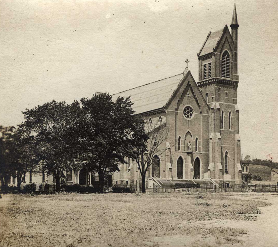
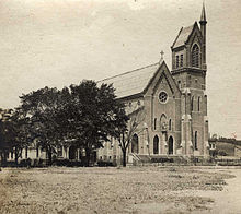 Sacred Heart Church in 1905
In 1876 the Sacred Heart Church was built on Walter Street for its large Irish Catholic population.[12] In 1865 Peter Cagger purchased the lot at the corner of Broadway and North Ferry Steet for the Roman Catholic Diocese of Albany, which they used as the St. Vincent's Orphan Asylum. Upon his death his widow donated money to convert the building into a hospital, named St. Peter's Hospital in his honor. The hospital opened in 1869 with 33 beds and a staff of 7 doctors and the Sisters of Mercy as the nursing staff.[13] The hospital moved to its current location on New Scotland Avenue in 1930, the building on Broadway staying open as an out-patient clinic for another year before closing permanently.[14]
The WT&RR began running 8-motor electric cars between its North Albany car barns and West Troy in 1889. In 1892 the Albany Railway also erected electric car barns in North Albany. [11]
-
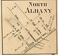
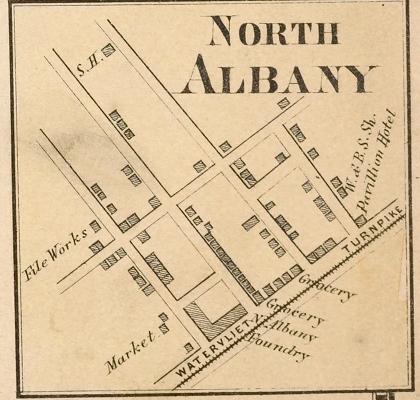
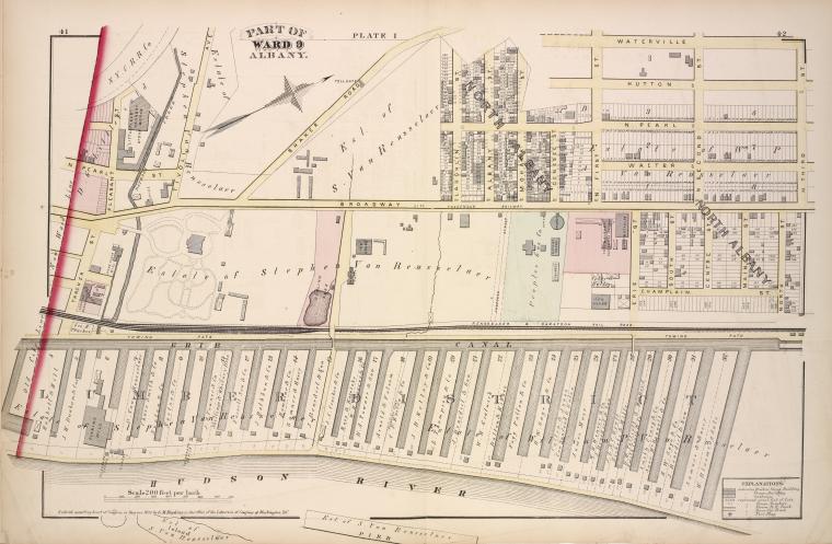
Map of North Albany
in 1866 -
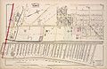
Map of North Albany in 1878 (North is to right)
-
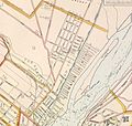
Map of North Albany
in 1891
After 1900
When at the turn of the 20th century Albany built its first water filtration plant, it was located in North Albany.[15]
Many of North Albany's former turnpikes continued to be of importance to long-distance travel throughout the 20th century as evidenced by the designation of several US and state routes. North Pearl Street was extended from Pleasant Street to Emmett Street and then on to the city line at the village of Menands in 1925,[2] and as a consequence of the 1930 renumbering of state highways in New York North Pearl Street became a part of New York Route 32 (NY 32).[citation needed] In the 1940s NY Route 2 (NY 2) was extended south to NY Route 5 (NY 5) downtown by way of an overlap with NY 32.[16][17] NY 2 was rerouted in the early 1950s to leave NY 32 at the junction of Wolfert Avenue and Broadway in Menands and then follow Broadway into downtown.[18][19] In the mid-1960s, Route 2 was shortened to end prior to North Albany.[20][21]
In 1950 North Albany held the neighborhood's first St. Patrick's Day Parade, one year before the city-wide parade began.[22] Whereas the city parade has been postponed occasionally due to weather, the neighborhood parade has not ever been cancelled or postponed even when there was 23 inches of snow on the ground in 1993.[23]
In 1953 the Edwin Corning Homes, a public housing complex, was built in North Albany,[2] as affordable housing for soldiers returning home from World War II.[24] It was named for Edwin Corning, former Lieutenant Governor of New York, son of railroad baron and mayor, Erastus Corning, and father of Mayor Erastus Corning 2nd.
During the 1960s the Albany municipal landfill was located on the site of a former river water filtration plant that operated from the early 1900s to the 1930s. While the tanks are assumed to have been demolished, several structures associated with the plant are still buried under the trash, such as concrete foundations and tunnel structures.[25] Located along Erie Boulevard on approximately 45 acres (18 ha) between Interstate 787 (I-787), Interstate 90 (I-90), Erie Boulevard, and the Albany County Wastewater Treatment Plant, it was closed to municipal waste in 1969 in favor of a new landfill in the Albany Pine Bush area in the western section of the city.[25][26] The landfill continued to operate as the North Albany Demolition Landfill, for demolition/construction debris until 1988.[27] The city's Department of Public Works garage was built on a part of the landfill,[28] with land near by used for the creation of the 92,000 square feet (8,500 m2) Erie Boulevard Commerce Park on 16.6 acres (6.7 ha).[29] Original plans were for Erie Boulevard, which was built on top of the old Erie Canal, to be extended through to Menands to Exit 6 of I-787.[29][30] Though Albany would have borne all the costs of construction Menands still refused.[30] Erie Boulevard was subsequently built to the border and no further in 1988 as part of the park construction.[29][31]
The first female mail carrier in the city of Albany worked out of the Patroon Station in North Albany, beginning in 1970. She may even have been the first in the entire Capital District.[32] In 2011 the Patroon Station closed, though by that time it no longer was responsible for home delivery and home delivery continued with no changes in ZIP Code, PO Boxes were able to be transferred to the Loudonville post office 4 miles (6.4 km) away in the neighboring town of Colonie.[33]
In 2000 Denis Foley and Andrew Wolfe, two Union College professors, unearthed in an archeological excavation the first weigh lock of the Erie Canal.[34]
In the 1990s and 2000s the blue-collar warehouse and manufactoring backbone of North Albany began to move upscale towards more eclectic reuse of industrial and service infrastructure. As part of the shift from heavy manufacturing to a more service oriented economy the Albany Common Council in 1999 changed the zoning for much of North Albany between Erie Boulevard and I-787 (west to east) and Livingston Avenue and I-90 (south to north). The roughly 100 acres (40 ha) affected were changed from industrial use only to C-3, Central Business District which allowed for sports stadiums, museums, hotels, apartment buildings, and general commercial uses.[35] In 1991 Albany Fire Department's Engine #3 was closed,[36] and it became a nightclub by the name of Noche, then a live music venue named Jack Rabbit Slims, and today is an authentic German beer garden named Wolff's Biergarten und Wurst Haus. [37][38] Huck Finn's Warehouse and More, a discount furniture store, which had been located on Tivoli Street, moved across North Albany to a former paper mill that had been converted in to a warehouse owned by Montgomery Ward from 1975 to 1998.[39] The Tivoli Street location became the home of the Albany County Hall of Records in 2001, home to the original Dongan Charter.[40] In 2007 At The Warehouse, a weekend art, craft, and food marketplace, took over a building built in 1892 that had previously been a brewery.[41][42]
In 1999, Sacred Heart Church became the first Roman Catholic church in Albany to be led by a deacon as parish life director due to a shortage of priests. In addition to changing times in leadership, the church community saw fewer of its traditional Irish congregation and increasing numbers of minorities. The reverend of the black apostolate at St. George's became the sacramental minister for masses, and a Vietnamese reverend celebrates a Vietnamese mass on the first and second Sundays of every month.[43] In 2006 the Sacred Heart Church's former convent next door was refurbished as an apartment complex for formerly homeless veterans.[44]
In 2001, the Corning Homes projects were redeveloped into a low-density development of town homes with Dutch-style pitched roofs. The Corning Homes name was dropped so as not to continue to stigmatize the low-income housing residents in an attempt to blend them in with the rest of the North Albany neighborhood.[24]
In 2005, a completely renovated Public School No. 5 on North Pearl Street was renamed North Albany Academy.[45] Begun in 2004 and completed in 2005 a YMCA (Y) was built attached to the school, with the students using the gym and pool during the day. The Y includes a branch of the Albany Public Library and a day care for pre-school children. The Y was the first in the Capital District to involve the organization partnering with a local government, among other sources funding came from the Albany Housing Authority, Citizens Bank, the state Dormitory Authority and the state Office of Children and Family Services.[46] The Y was the first in the United States built using tax breaks from the New Market Tax Credit and was the first built in Albany since the 1960s.[47]
Utility company National Grid's regional headquarters are located at 1125 Broadway in North Albany on the site of the former Albany Gas Works. The gasworks in the 19th century produced a crude form of natural gas for gaslight street lamps using coal gasification methods. The tar left behind contamination that was cleaned up in 1996 by Niagara Mohawk (National Grid's predecessor). [48] In 2010, National Grid established a compressed natural gas station there; in addition to cutting down on emissions from National Grid's fleet of trucks it is open to the public, allowing for increased ability for those with natural gas vehicles to fuel.[49]
Geography
North Albany is bounded roughly by the railroad overpass on Broadway to the south and the city line with Menands to the north; and from the Hudson River to the east and Van Rensselaer Boulevard on the west. The area includes many older industrial sites along Broadway and North Pearl Street, with newer industrial uses along Erie Boulevard.[50]

Town of Colonie
Village of MenandsVan Rensselaer Boulevard 
Hudson River/Rensselaer County
City of Rensselaer North Albany

Arbor Hill Economy
North Albany's is the site of the largest industrial area in the city of Albany, and is the most concentrated area of industry as well. Approximately 75 industrial businesses are located in the historic heart of North Albany, an area of approximately 1 square mile (2.6 km2). Though most of those businesses tend to be small, they account for around 2,000 jobs total. Government operations are present as well, including the New York State Assembly's printing operations.[51] Both private and public actions have attempted to change North Albany from a heavy industry economy to a "Warehouse District" of artistic and entertainment venues reusing old warehouses and city infrastructure. In addition to a German beer garden in the former AFD Engine #3 and an arts/crafts/food marketplace in an old beer factory, in 2011 an Irish pub opened in a former office furniture showroom and a rock and roll/country music live music venue and bar in a former bank building, both are within one block of the beer garden.[52]
Transportation
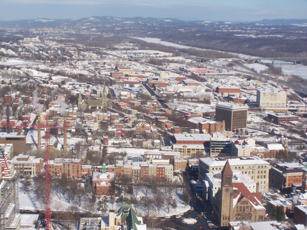
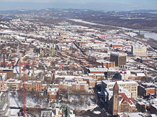 North Albany as seen from the Corning Tower
Along the southern boundary of North Albany lies a railroad owned by CSXT (the Chicago Line), which is also used by Amtrak. The former D&H Colonie Main Line (now owned by CP Rail) runs through North Albany, at Erie Street and Erie Boulevard sits a bulk transfer rail yard operated by BULK Transfer Services LLC.[53][54]
North Albany's main streets are North Pearl Street and Broadway which run north-south from Arbor Hill and Downtown to Menands. Most other streets in the neighborhood are cross streets that intersect either or both of those main streets. North Pearl Street is also part of NY 32. Loudonville Road connects North Pearl Street and Broadway northwest to US 9 and Van Rensselaer Boulevard. Van Rensselaer Boulevard on the western border of North Albany travels north to Menands and the Albany Rural Cemetery, at the intersection with Northern Boulevard and Lawn Avenue it becomes New York Route 377 (NY 377). I-90 cuts through the neighborhood and intersects with I-787 along the Hudson River crossing the Patroon Island Bridge into the city and county of Rensselaer. I-787 travels along the Hudson River at the eastern edge of North Albany and at exit 4A at Water and North Ferry streets allows access to the southern edge of the neighborhood.
Landmarks
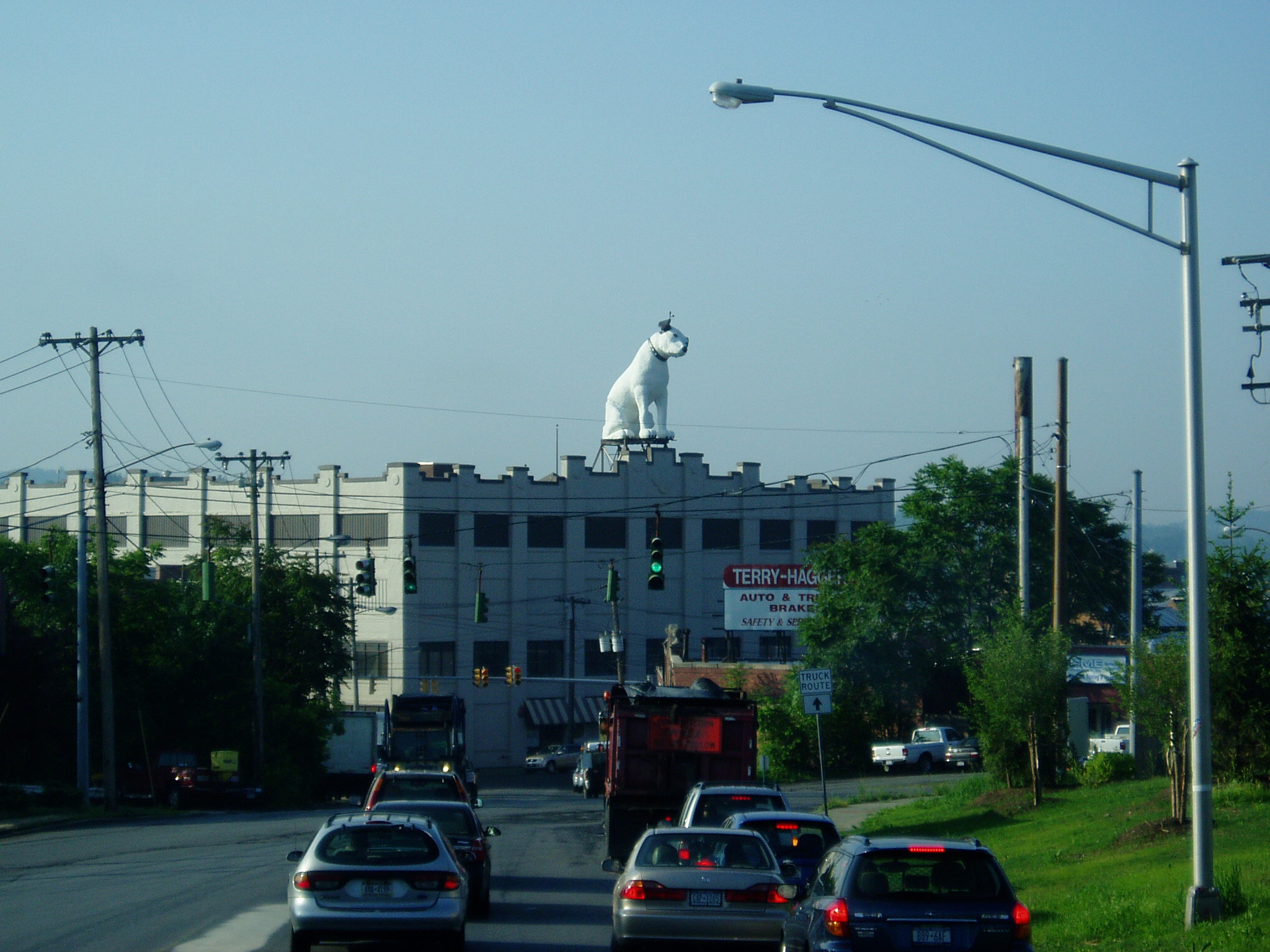
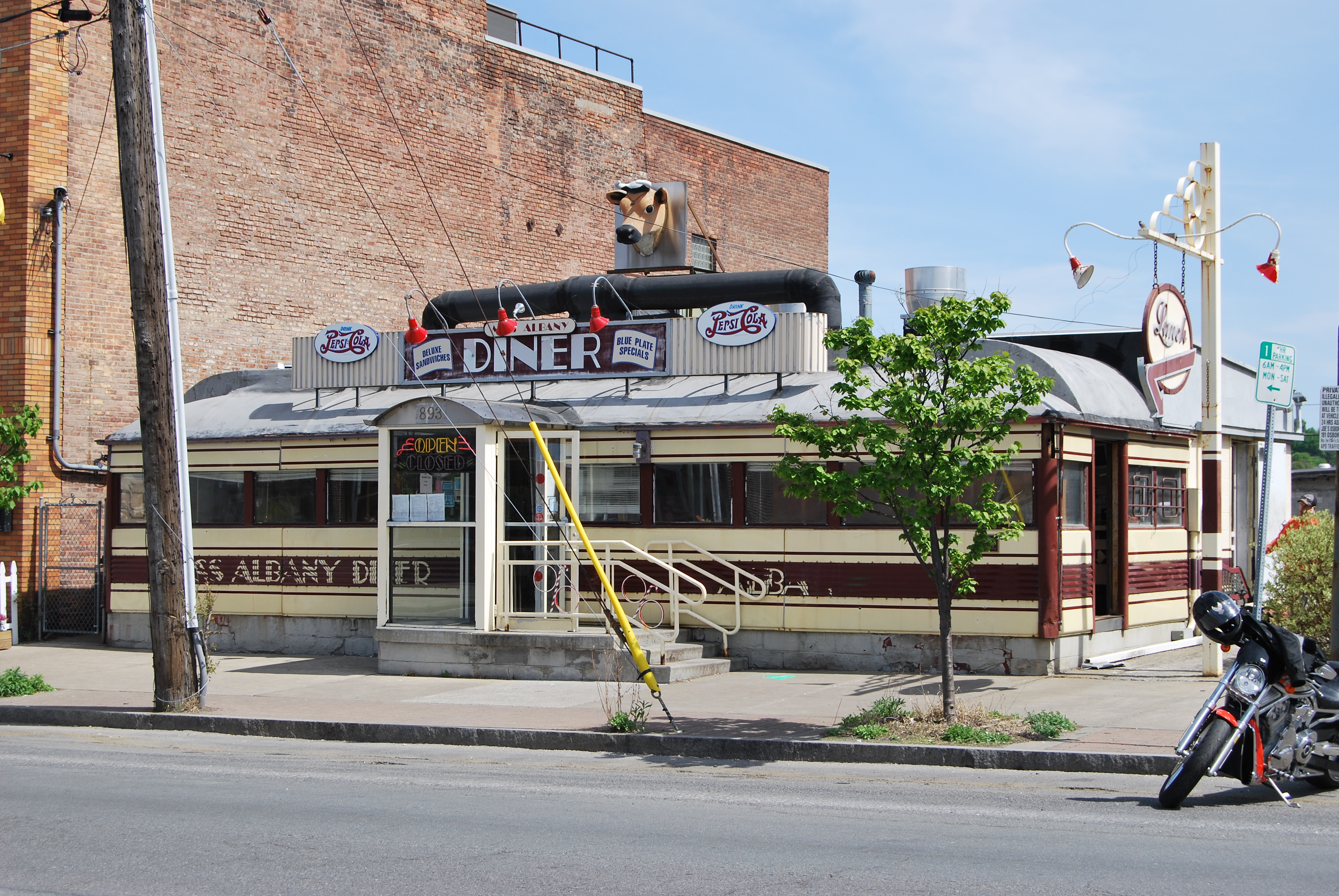
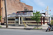 Miss Albany Diner
Built in 1954 for the RTA Corp., a distributor for RCA, Nipper is a 4–ton (3.6 metric ton), 24-foot (7.3 m) tall replica of the RCA mascot. He is currently the tallest known replica of the dog in existence.[55] Nipper is composed of a composite body over a steel frame, and sports an aircraft warning beacon on his left ear, the dog can be seen as far as 5 miles (8.0 km) away in East Greenbush.[56]
Listed on the National Register of Historic Places (NRHP) in 2000, the Miss Albany Diner has been located in North Albany along Broadway since 1941. It hosted Jack Nicholson and Meryl Streep during their filming of the movie Ironweed. A movie called Grazing Miss Albany is scheduled to be filmed in the diner.[57]
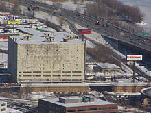 The Central Warehouse in 2011 as seen from the Corning Tower
Central Warehouse is a refrigeration warehouse in North Albany along Colonie Street at the very southern edge of North Albany. Built in 1927 it is 11-stories tall with 40,000 square feet (3,700 m2) of space, and is considered a landmark of the community and city.[58] The building has a rail line that enters the second floor and the walls are 3 feet (0.91 m) thick concrete.[59] In 1981 the building began to have signs placed on it seen from I-787, and in 1983 one in particular "Year of the Bible" received numerous complaints and the state began proceedings to have it removed. The signs violated the Federal Highway Beautification Act and was removed in 1986. Previous signs from 1981 to 1983 were not disputed by the state because Albany Mayor Erastus Corning 2nd had personally approved them and the New York State Department of Transportation (NYSDOT) chose not to enforce the law since it would be against Corning's wishes,[60] Corning died in 1983. In 1996 the building, which by then had been abandoned, was found to have up to 18 inches (460 mm) of ice built up on some floors. The ice it was believed was keeping the ammonia of the refrigeration system from expanding, bursting pipes, and being released into the atmosphere.[58] The building was abandoned in the early 1990s.[61] The ammonia was subsequently drained from the pipes.[62] On October 22, 2010 a fire began in the warehouse and lasted for days, the current owners claimed no structural damage was done to the building and that plans to renovate the building into a residential and retail complex were still possible, over $1 million had already been invested in cleaning the insides of the building. [63]
Notable residents
- Admiral Walter F. Doran (Retired)- Former commander of the US Pacific Fleet[64]
- William Kennedy- Pulitzer Prize winning author, a native of North Albany, many of his novels feature the neighborhood such as Ironweed which became a film of the same name featuring Jack Nicholson and Meryl Streep.
- Mayor Jerry Jennings- 74th mayor of Albany, and third-longest serving at 18 years as of 2011.
References
- ^ Van Laer, A.J.F., ed (1918). Early Records of the City and County of Albany and Colony of Rensselaerswyck. 3. The University of the State of New York/New York State Library. p. 499. http://books.google.com/books?id=7idVAAAAYAAJ&pg=PA499&dq=%22north+albany%22+-georgia&hl=en&ei=xcfaTbSJFKn50gGr3YD8Aw&sa=X&oi=book_result&ct=result&resnum=9&ved=0CFIQ6AEwCDg8#v=onepage&q=%22north%20albany%22%20-georgia&f=false.
- ^ a b c d e "North Albany". Albany Institute of History and Art. http://www.albanyinstitute.org/info/exhibits/city%20neighborhoods/north%20albany/North%20Albany.htm. Retrieved 2011-05-23.
- ^ The Albany Lumber Trade: its history and extent. The Argus Company. 1872. p. 10. http://books.google.com/books?id=_XkDAAAAYAAJ&pg=PA9&dq=albany+lumber+district&as_brr=0. Retrieved 2009-07-17.
- ^ James Defebaugh (1907). History of the Lumber Industry of America (Volume 2). 2. The American Lumberman. p. 408. http://books.google.com/books?id=MxILAAAAIAAJ&pg=PA414&dq=albany+lumber+district&as_brr=0.
- ^ The Albany Lumber Trade: its history and extent. The Argus Company. 1872. p. 7. http://books.google.com/books?id=_XkDAAAAYAAJ&pg=PA9&dq=albany+lumber+district&as_brr=0. Retrieved 2009-07-17.
- ^ Howell, George Rogers; Tenney, Jonathan (1886). History of the County of Albany, N.Y., From 1609 to 1886. W.W. Munsell & Co.. p. 945. http://books.google.com/books?id=6UdbEIAEit8C&pg=PA945&lpg=PA945&dq=watervliet+turnpike+and+railroad+company&source=bl&ots=_sHgMRBvwg&sig=0BBFINedsn8SxhcGwDpi0ciWSwQ&hl=en&ei=BrfaTeONFMqltweX4sXoDg&sa=X&oi=book_result&ct=result&resnum=3&ved=0CCMQ6AEwAg#v=onepage&q=watervliet%20turnpike%20and%20railroad%20company&f=false.
- ^ French, J.H. (1860). Gazetteer of the State of New York: Embracing a Comprehensive View of the Geography, Geology, and General History of the State, and a Complete History and Description of Every City, Town, Village, and Locality, with Full Tables and Statistics. R. Pearsall Smith. p. 166. http://books.google.com/books?id=mZQ-AAAAYAAJ&pg=PA166&dq=%22north+albany%22+-georgia&hl=en&ei=R8jaTaWkPNCatwfQpLXoDg&sa=X&oi=book_result&ct=result&resnum=9&ved=0CFMQ6AEwCDhG#v=onepage&q=%22north%20albany%22%20-georgia&f=false.
- ^ a b "Appendix". Albany County. http://www.albanycounty.com/departments/achor/inout/ichap5.html.
- ^ "North Albany Nurtures its Irish Roots". Times Union (Albany) (Hearst Communications): p. H1. 1994-01-16. http://albarchive.merlinone.net/mweb/wmsql.wm.request?oneimage&imageid=5705688.
- ^ City of Albany. City of Albany, NY Fourth Ward (PDF map). http://www.albanyny.org/_files/Government/CityClerk/FourthWard.pdf. Retrieved 2011-05-24.
- ^ a b Reynolds, Cuyler, ed (1906). Albany Chronicles: A History of the City Arranged Chronologically. J.B. Lyon Company. http://books.google.com/books?id=XNU0AAAAIAAJ&pg=PA724&dq=%22north+albany%22+-georgia&hl=en&ei=gcbaTY23LZDAgQeGuJxY&sa=X&oi=book_result&ct=result&resnum=8&ved=0CFIQ6AEwBzgo#v=onepage&q=%22north%20albany%22&f=false.
- ^ Polgreen, Lydia (2000-08-07). "Forgiven Debt Renews Church". Times Union (Albany) (Hearst Communications): p. B1. http://albarchive.merlinone.net/mweb/wmsql.wm.request?oneimage&imageid=6064070.
- ^ "St. Peter's: The Beginning". St. Peter's Hospital. 2005. http://www.sphcs.org/History/beginning.htm. Retrieved 2011-05-30.
- ^ "A New Home". St. Peter's Hospital. 2005. http://www.sphcs.org/History/newHome.htm. Retrieved 2011-05-30.
- ^ "Notable People". Albany Rural Cemetery. http://www.albanyruralcemetery.org/albrurcem/Notable.html. Retrieved 2011-05-25.
- ^ Esso (1942). New York with Pictorial Guide (Map). Cartography by General Drafting.
- ^ Esso (1940). New York (Map). Cartography by General Drafting.
- ^ Sunoco (1952). New York (Map). Cartography by Rand McNally and Company.
- ^ Esso (1954). New York with Special Maps of Putnam–Rockland–Westchester Counties and Finger Lakes Region (Map). Cartography by General Drafting (1955–56 ed.).
- ^ Esso (1962). New York with Sight-Seeing Guide (Map). Cartography by General Drafting.
- ^ Esso (1968). New York (Map). Cartography by General Drafting (1969–70 ed.).
- ^ Brown, Cailin (1996-03-14). "Albany Falls into Step With its Irish Heritage". Times Union (Albany) (Hearst Communications): p. B1. http://albarchive.merlinone.net/mweb/wmsql.wm.request?oneimage&imageid=5805404.
- ^ Demare, Carol (2011-03-11). "Irish Eyes Will be Smiling Saturday". Times Union (Albany) (Hearst Communications): p. D1. http://albarchive.merlinone.net/mweb/wmsql.wm.request?oneimage&imageid=13851327.
- ^ a b Polgreen, Lydia (2001-11-25). "New Town Houses Reflect New Thinking". Times Union (Albany) (Hearst Communications): p. D1. http://albarchive.merlinone.net/mweb/wmsql.wm.request?oneimage&imageid=6079058.
- ^ a b Knowles, G. David and Landva, Arvid, ed (1990). Geotechnics of Waste Fills: Theory and Practice. American Society for Testing and Materials. p. 42. ISBN 0-8031-1285-8. http://books.google.com/books?id=1gkh7vFdCiQC&printsec=copyright&source=gbs_pub_info_s&cad=3#v=onepage&q&f=false.
- ^ Carleo-Evangelist, Jordan (2011-01-31). "Buried in Trash". Times Union (Albany) (Hearst Communications). http://www.timesunion.com/default/article/Buried-in-trash-985672.php#photo-4.
- ^ "City Closes Landfill on Erie Blvd". Times Union (Albany) (Hearst Communications): p. B2. 1988-11-04. http://albarchive.merlinone.net/mweb/wmsql.wm.request?oneimage&imageid=5497539.
- ^ Kelly, Brad (1989-03-21). "Albany Council OK's $7.1 M in Bonds". Times Union (Albany) (Hearst Communications): p. B2. http://albarchive.merlinone.net/mweb/wmsql.wm.request?oneimage&imageid=5536730.
- ^ a b c "7 Firms Reportedly Lined Up for Albany Industrial Park". Times Union (Albany) (Hearst Communications): p. 3A. 1998-01-20. http://albarchive.merlinone.net/mweb/wmsql.wm.request?oneimage&imageid=5505992.
- ^ a b Schick, Timothy F. (1986-06-17). "Menands Canal Eyed for Road". Times Union (Albany) (Hearst Communications): p. B2. http://albarchive.merlinone.net/mweb/wmsql.wm.request?oneimage&imageid=5476545.
- ^ Gesensway, Deborah (1988-06-22). "Three Firms Get OK to Buy Albany Industrial Park Parcels". Times Union (Albany) (Hearst Communications): p. B3. http://albarchive.merlinone.net/mweb/wmsql.wm.request?oneimage&imageid=5489915.
- ^ DeMare, Carol (2006-06-06). "Female Met Mail Challenges". Times Union (Albany) (Hearst Communication): p. B3. http://albarchive.merlinone.net/mweb/wmsql.wm.request?oneimage&imageid=6407528.
- ^ Carleo-Evangelist, Jordan (2011-02-18). "Patroon Station Site to Close". Times Union (Albany) (Hearst Communications): p. D6. http://albarchive.merlinone.net/mweb/wmsql.wm.request?oneimage&imageid=13612701.
- ^ Polgreen, Lydia (2000-11-22). "Find Renews Faith in Canal Restoration Fight". Times Union (Albany) (Hearst Communications): p. B1. http://albarchive.merlinone.net/mweb/wmsql.wm.request?oneimage&imageid=6030608.
- ^ Benjamin, Elizabeth (1999-11-24). "Change Extends Business District". Times Union (Albany) (Hearst Communications): p. F1. http://albarchive.merlinone.net/mweb/wmsql.wm.request?oneimage&imageid=5958791.
- ^ Liquori, Donna (1991-04-14). "It's the End for Engine 3 Albany Neighbors Protest Closing". Times Union (Albany) (Hearst Communications): p. C1. http://albarchive.merlinone.net/mweb/wmsql.wm.request?oneimage&imageid=5598319.
- ^ Barnes, Steve (2008-11-07). "Broadway Beer Garden Brewing". Times Union (Albany) (Hearst Communications): p. C1. http://albarchive.merlinone.net/mweb/wmsql.wm.request?oneimage&imageid=7154691.
- ^ "Wolff's Biergarten". Wolff's Biergarten. http://www.wolffsbiergarten.com/main.html. Retrieved 2011-04-24.
- ^ Abbey, Allen D. (1995-01-12). "Major Growth in Store for Huck Finn's Albany Retailer Prepares to Triple its Size and Anchor New Discount Marketplace". Times Union (Albany) (Hearst Communications): p. C8. http://albarchive.merlinone.net/mweb/wmsql.wm.request?oneimage&imageid=5755929.
- ^ Woodruff, Cathy (2001-02-11). "Records are on the Move". Times Union (Albany) (Hearst Communications): p. E6. http://albarchive.merlinone.net/mweb/wmsql.wm.request?oneimage&imageid=6091876.
- ^ Churchill, Chris (2007-03-23). "City Marketplace to Defy Labels". Times Union (Albany) (Hearst Communications): p. E1. http://albarchive.merlinone.net/mweb/wmsql.wm.request?oneimage&imageid=6450161.
- ^ "Welcome to At The Warehouse". At The Warehouse. 2009. http://www.atthewarehouse.net/index.html. Retrieved 2011-05-24.
- ^ McCarthy, Catherine (1999-06-07). "Deacon Leads North Albany Church to Change". Times Union (Albany) (Hearst Communications): p. C1. http://albarchive.merlinone.net/mweb/wmsql.wm.request?oneimage&imageid=5992625.
- ^ Nearing, Brian (2006-05-16). "Doors Open for Homeless Veterans". Times Union (Albany) (Hearst Communications): p. B1. http://albarchive.merlinone.net/mweb/wmsql.wm.request?oneimage&imageid=6399211.
- ^ Karlin, Rick (2005-07-21). "New School Awaits a Name". Times Union (Albany) (Hearst Communications): p. B6. http://albarchive.merlinone.net/mweb/wmsql.wm.request?oneimage&imageid=6348306.
- ^ Nearing, Brian (2005-11-15). "North Albany YMCA Opens". Times Union (Albany) (Hearst Communications): p. B9. http://albarchive.merlinone.net/mweb/wmsql.wm.request?oneimage&imageid=6307780.
- ^ Nearing, Brian (2004-11-17). "Tax Break Jump-Starts Work on YMCA". Times Union (Albany) (Hearst Communications): p. B1. http://albarchive.merlinone.net/mweb/wmsql.wm.request?oneimage&imageid=6263139.
- ^ "Old Gas Sites Leave Legacy of Pollution". Times Union (Albany) (Hearst Communications): p. E1. 1996-11-08. http://albarchive.merlinone.net/mweb/wmsql.wm.request?oneimage&imageid=5788738.
- ^ Rulison, Larry (2010-11-23). "Fill Up the Tank With Natural Gas". Times Union (Albany) (Hearst Communications): p. D1. http://albarchive.merlinone.net/mweb/wmsql.wm.request?oneimage&imageid=12807421.
- ^ "LUST Recovery One Year Stories: North Albany, New York". Environmental Protection Agency. February 2010. http://www.epa.gov/oust/docs/ny_recact1yr_story.pdf. Retrieved 2011-05-26.
- ^ Yu, Winifred (1994-02-27). "Made in North Albany From Soup to Nuts, Manufactoring Center Keeps Neighborhood Afloat". Times Union (Albany) (Hearst Communications): p. CAP15. http://albarchive.merlinone.net/mweb/wmsql.wm.request?oneimage&imageid=5711937.
- ^ Barnes, Steve (2011-05-26). "For Food, Drink Think: 'Warehouse'". Times Union (Albany) (Hearst Communications). http://www.timesunion.com/business/article/For-food-drink-think-warehouse-1396198.php.
- ^ "New York Bulk Intermodal Transload Facility". Penton Media, Inc.. http://bulktransporter.com/transload/2008_transload_directory_states/new_york/. Retrieved 2011-05-25.
- ^ Sconfienza, Steve. "Steve's Railroad Pages: Local Information". http://members.localnet.com/~docsteve/railroad/local.htm#top. Retrieved 2011-05-25.
- ^ Gurnett, Kate (1997-09-16). "Save Our Nipper, Neighbors Urge". Times Union (Albany) (Hearst Communications): p. A1. http://albarchive.merlinone.net/mweb/wmsql.wm.request?oneimage&imageid=5829825.
- ^ Liquori, Donna (1994-11-20). "Nipper Marks 40th Year of Watching Over Albany the 25-Foot Tall, 4-Ton Fox Terrier Is Visible As Far Away as East Greenbush". Times Union (Albany) (Hearst Corporation): p. C3. http://albarchive.merlinone.net/mweb/wmsql.wm.request?oneimage&imageid=5698875.
- ^ Miller, Anne (2006-01-21). "Diner and a Movie". Times Union (Albany) (Hearst Communications): p. I1. http://albarchive.merlinone.net/mweb/wmsql.wm.request?oneimage&imageid=6380788.
- ^ a b Roy, Yancey (1996-03-29). "Vacco Acts to Avoid Environmental Emergency". Times Union (Albany) (Hearst Communications): p. B10. http://albarchive.merlinone.net/mweb/wmsql.wm.request?oneimage&imageid=5807477.
- ^ O'Brien, Tim (2010-10-23). "Warehouse to Burn for Days". Times Union (Albany) (Hearst Communications): p. A1. http://albarchive.merlinone.net/mweb/wmsql.wm.request?oneimage&imageid=12467717.
- ^ Armstrong, Shirley (1986-11-12). "'Year of the Bible' Ending State Persuades Firm to Cover 1983 Sign". Times Union (Albany) (Hearst Communications): p. B1. http://albarchive.merlinone.net/mweb/wmsql.wm.request?oneimage&imageid=5460353.
- ^ O'Brien, Tim (2010-10-23). "Warehouse to Burn for Days". Times Union (Albany) (Hearst Communications): p. A1. http://albarchive.merlinone.net/mweb/wmsql.wm.request?oneimage&imageid=12467717.
- ^ Denn, James (1997-06-27). "Buyer Bucks Market Glut". Times Union (Albany) (Hearst Communications): p. B9. http://albarchive.merlinone.net/mweb/wmsql.wm.request?oneimage&imageid=5870987.
- ^ Churchill, Chris (2010-11-02). "Prospects for Warehouse Not Up in Smoke". Times Union (Albany) (Hearst Communications): p. D1. http://albarchive.merlinone.net/mweb/wmsql.wm.request?oneimage&imageid=12569185.
- ^ Scruton, Bruce A. (2002-05-04). "Albany Native to Lead Fleet in Pacific". Times Union (Albany) (Hearst Communications): p. B1. http://albarchive.merlinone.net/mweb/wmsql.wm.request?oneimage&imageid=6171429.
History GeneralHistory (Prehistory–1664, 1664–1784, 1784–1860, 1860–1900, 1900–1942, 1942–1983, 1983–present) · Architecture · National Register of Historic Places listings17th centuryMohawks · Mahicans · Dutch West India Company (1621–1791) · Fort Nassau (1614) · Fort Orange (1624) · Rensselaerswijck (1629–1840) · Beverwijck (1652–1664) · Stadt Huys (1635, 1646, or 1673) · Fort Frederick (1676–1789) · Dongan Charter (1686)18th centuryVan Ostrande-Radliff House (1728) · Quackenbush House (1736) · Albany Plan of Union (1754) · Schuyler Mansion (1765)19th centuryClermont (1807) · Erie Canal (1825) · Albany Basin (1825) · Albany Lumber District (1830s–1908) · City Hall (1832) · Governor's Mansion (1856) · City Hall (1883) · New York State Capitol (1899)20th centuryAlbany Municipal Airport (1908) · Miss Albany Diner (1941) · W. Averell Harriman State Office Building Campus (1956–1994) · Albany County Airport (1960) · Empire State Plaza (1965–1978) · Times Union Center (1990) · Albany International Airport (1996–1998)21st centuryHudson River Way (2002) · Albany Convention Center (proposed)
Government Mayor of Albany (current: Gerald Jennings) · Albany City Hall · Coat of arms · See also: Government of New YorkNeighborhoods Arbor Hill · Buckingham Pond · Center Square · Delaware Avenue · Dudley Heights · Dunes · Eagle Hill · Helderberg · Hudson-Park · Melrose · New Albany · Normansville · North Albany · Park South · Pine Hills · Sheridan Hollow · South End (Kenwood · Krank Park · Mansion District · Mount Hope · The Pastures · Second Avenue) · University Heights · Washington Park · West Hill · WhitehallPeople Thomas Dongan (1634–1715) · Peter Schuyler (1657–1724) · Erastus Corning (1794–1872) · Daniel P. O'Connell (1885–1977) · Erastus Corning 2nd (1909–1983) · John McEneny (1943–present)Geography LandAlbany Pine Bush · Westerlo IslandWaterBuckingham Lake · Hudson River (Valley) · Normans Kill · Patroon Creek · Rensselaer Lake · Tivoli Lake · Washington Park LakeEducation SecondaryAcademy of the Holy Names · The Albany Academy · Albany Academy for Girls · Albany Free School · Bishop Maginn High School · City School District of Albany (Albany High School) · LaSalle School · See also: List of school districts in New York's Capital DistrictHigherAlbany College of Pharmacy and Health Sciences · Albany Law School · Albany Medical College · College of Saint Rose · Excelsior College · Maria College · Mildred Elley · Sage College of Albany · SUNY Albany · See also: List of colleges and universities in New York's Capital DistrictReligion Episcopal Diocese of Albany (Cathedral of All Saints · Bishop William Love) · Roman Catholic Diocese of Albany (Cathedral of the Immaculate Conception · Bishop Howard Hubbard)Culture Culture in New York's Capital District · Sports in New York's Capital DistrictTransportation Adirondack Northway · Albany-Rensselaer Rail Station · Albany International Airport · CDTA · Interstate 87 · Interstate 90 · Interstate 787 · New York State Thruway · Port of Albany–Rensselaer · Streets of Albany, New YorkMunicipalities and communities of Albany County, New York Cities Albany | Cohoes | Watervliet

Towns Berne | Bethlehem | Coeymans | Colonie | Green Island | Guilderland | Knox | New Scotland | Rensselaerville | Westerlo
Villages Altamont | Colonie | Green Island | Menands | Ravena | Voorheesville
CDPs Other
hamletsAlcove | Boght Corners | Clarksville | Crescent Station | Dunsbach Ferry | Elsmere | Feura Bush | Fort Hunter | Fullers | Glenmont | Guilderland | Guilderland Center | Karner | Latham | Lisha Kill | Loudonville | Mannsville | McKownville | New Salem | Newtonville | Normansville | Roessleville | Selkirk | Slingerlands | South Bethlehem | Verdoy | West Albany
Capital District of New York Central communities Albany (History · City Hall · Coat of Arms) · Schenectady (City Hall) · Troy (History) · List of all incorporated places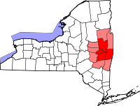
Largest communities
(over 20,000 in 2000)Medium-sized communities
(10,000 to 20,000 in 2000)City of Amsterdam · Brunswick · Cohoes · East Greenbush · Glens Falls · Gloversville · Halfmoon · Malta · North Greenbush · Schodack · Watervliet · WiltonSmall communities
(5,000 to 10,000 in 2000)Town of Amsterdam · Ballston Spa · Cobleskill · Village of Colonie · Duanesburg · City of Johnstown · Town of Johnstown · Kinderhook · Mechanicville · New Scotland · Rensselaer · Sand Lake · Scotia · Town of Stillwater · WaterfordCounties Albany · Columbia · Fulton · Greene · Montgomery · Rensselaer · Saratoga · Schenectady · Schoharie · Warren · WashingtonHistory Mohawks · Mahicans · Fort Orange · Rensselaerswyck · Beverwyck · Albany Plan of Union · Timeline of town creation · Toponymies of places · Tech ValleyGeography Hudson River (Valley) · Mohawk River · Erie Canal · Lake Albany · Lake George · Albany Pine Bush (Rensselaer Lake · Woodlawn Preserve) · Adirondack Mountains · Catskill Mountains · Rensselaer PlateauReligion and culture Culture in New York's Capital District · Sports in New York's Capital District · Episcopal Diocese of Albany · Roman Catholic Diocese of AlbanyEducation Public school districtsList of school districts in New York's Capital DistrictHigher educationNewspapers TV/Radio Broadcast television in the Capital District Local stations WRGB (6.1 CBS, 6.2 This TV) • WTEN (10.1 ABC, 10.2 Weather, 10.3 RTV) • WNYT (13.1 NBC, 13.2 Weather, 13.3 Weather Radar) • WMHT (17.1 PBS, 17.2 ThinkBright, 17.3 HD) • WXXA (23.1 Fox, 23.2 The Cool TV) • WNGN-LP 35 / WNGX-LP 42 (FN) • WCWN (45.1 The CW, 45.2 Uni Sp) • WNYA / WNYA-CD (51.1 MNTV, 51.2 Antenna TV) • W52DF 52 (silent)
Outlying area stations WVBK-CA 2 (RSN' Manchester, VT) • W04AJ 4 (PBS; Glens Falls) • W04BD 4 (PBS; Schoharie) •
WNCE-CA 8 (A1; Glens Falls) • WYBN-CA 14 (RSN; Cobleskill) • WCDC (19.1 ABC; Adams, MA) • WVBG-LP 25 (RSN; Greenwich) • W36AX 36 (PBS / VPT; Manchester, VT) • W47CM 47 (silent; Glens Falls) • WYPX (55.1 Ion, 55.2 qubo, 55.3 Life; Amsterdam) • W53AS 53 (PBS / VPT; Bennington, VT)Adjacent locals Cable-only stations YNN Capital Region • TW3 • YES • SNY • MSG Network
Defunct stations New York State television: Albany/Schenectady • Binghamton • Buffalo • Burlington/Plattsburgh • Elmira • New York City • Rochester • Syracuse • Utica • Watertown
Vermont Broadcast television: Albany/Schenectady • Boston, MA • Burlington/Plattsburgh
Massachusetts television: Albany • Boston • Providence • Springfield
Radio stations in the Albany / Schenectady / Troy market by FM frequency 88.3 · 89.1² · 89.7 · 89.9 · 90.3/93.1² · 90.7/94.9 · 90.7 · 90.7 · 90.9 · 91.1 · 91.5 · 92.3 · 92.9 · 93.5 · 93.7 · 94.5 · 94.7 · 95.5 · 95.9 · 96.3 · 96.7 · 97.3 · 97.5 · 97.7 · 97.9 · 98.3² · 98.5 · 98.5 · 99.1 · 99.5² · 100.3 · 100.9 · 101.3 · 101.7 · 101.9 · 102.3² · 102.7 · 103.1² · 103.5 · 103.9 · 104.5 · 104.9 · 105.7² · 106.1 · 106.5² · 107.1 · 107.7²by AM frequency NOAA Weather Radio frequency 162.550by callsign W226AC · W235AY · W256BU · W291BY · WABY · WAJZ · WAMC (AM) · WAMC-FM² · WBAR · WBPM · WCDB · WCKL · WCKM · WCQL · WCSS · WCTW · WDCD · WDCD-FM · WDDY² · WENT · WEQX · WEXT · WFFG · WFLY · WFNY · WGDJ · WGNA² · WGXC · WGY¹² · WGY-FM² · WHAZ · WHAZ-FM · WHUC · WHVP · WIZR · WJIV · WKBE · WKKF² · WKLI · WLJH · WMHT² · WMYY · WNYQ · WOFX² · WOPG · WPGL · WPYX² · WQAR · WQBJ · WQBK · WQSH² · WRIP · WROW · WRPI · WRUC · WRVE² · WSDE · WTMM · WTRY² · WUAM · WVCR · WVKZ · WVTL · WXL34 · WYAI · WYJB · WYKV · WZCR · WZMRDefunct stations New York Radio Markets: Albany-Schenectady-Troy • Binghamton • Buffalo-Niagara Falls • Elmira-Corning • Hamptons-Riverhead • Ithaca • Nassau-Suffolk (Long Island) • New York City • Newburgh-Middletown (Mid Hudson Valley) • Olean • Plattsburgh • Poughkeepsie • Rochester • Syracuse • Utica-Rome • Watertown
Other New York Radio Regions: Jamestown-Dunkirk • North Country • Saratoga
See also: List of radio stations in New YorkCategories: -


Wikimedia Foundation. 2010.