- National Register of Historic Places listings in Monmouth County, New Jersey
-
List of the National Register of Historic Places listings in Monmouth County, New Jersey
Contents: Counties in New Jersey Atlantic - Bergen - Burlington - Camden - Cape May - Cumberland - Essex - Gloucester - Hudson - Hunterdon - Mercer - Middlesex - Monmouth - Morris - Ocean - Passaic - Salem - Somerset - Sussex - Union - Warren This is intended to be a complete list of properties and districts listed on the National Register of Historic Places in Monmouth County, New Jersey. The locations of National Register properties and districts (at least for all showing latitude and longitude coordinates below) may be seen in a Google map by clicking on "Map of all coordinates".[1]
-
- This National Park Service list is complete through NPS recent listings posted November 10, 2011.[2]
[3] Site name[4] Image Date listed Location[1] City or Town Summary 1 ALEXANDER HAMILTON (steamship) March 25, 1977 Off NJ 36
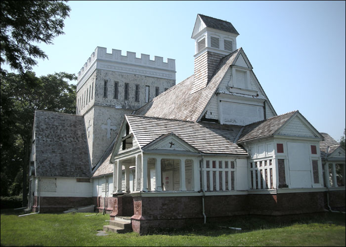
40°25′19″N 74°2′6″W / 40.42194°N 74.035°WAtlantic Highlands 2 All Saints' Memorial Church Complex 
February 15, 1974 Navesink Ave. and Locust Rd.
40°23′53.28″N 74°1′12.99″W / 40.3981333°N 74.020275°WNavesink 3 Allaire Village January 11, 1974 3 mi. SE of Farmingdale on NJ 524
40°9′31″N 74°7′44″W / 40.15861°N 74.12889°WFarmingdale 4 Allen House May 8, 1974 Broad St. and Sycamore Ave.
40°19′26″N 74°3′44″W / 40.32389°N 74.06222°WShrewsbury 5 Allenhurst Railroad Station September 17, 1980 Main St.
40°14′14″N 74°0′25″W / 40.23722°N 74.00694°WAllenhurst 6 Allenhurst Residential Historic District June 18, 2010 Roughly bounded by the Atlantic Ocean, Main St., Cedar Ave., Hume St., and Elberon Ave.
40°14′10.4″N 74°0′2.49″W / 40.236222°N 74.0006917°WAllenhurst 7 Allentown Historic District June 14, 1982 N. and S. Main Sts.
40°10′36″N 74°35′14″W / 40.17667°N 74.58722°WAllentown 8 Allentown Mill February 14, 1978 42 S. Main St.
40°10′34″N 74°35′13″W / 40.17611°N 74.58694°WAllentown 9 Allgor-Barkalow Homestead June 21, 1984 New Bedford Rd.
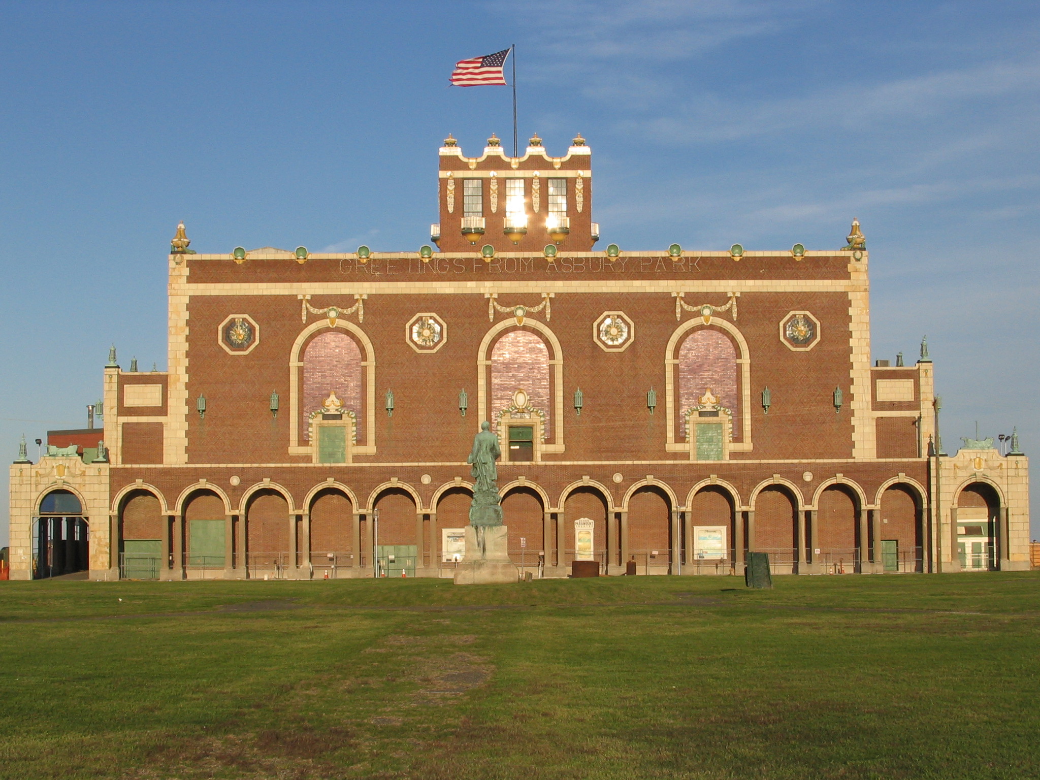
40°10′30″N 74°3′52″W / 40.175°N 74.06444°WAsbury Park 10 Asbury Park Convention Hall 
March 2, 1979 Ocean Ave.
40°13′22″N 73°59′56″W / 40.22278°N 73.99889°WAsbury Park 11 Audenried Cottage 
March 8, 1991 21 Tuttle Ave.
40°9′31″N 74°1′21″W / 40.15861°N 74.0225°WSpring Lake Now the Normandy Inn 12 Bradley Beach Station June 22, 1984 Between LaReine and Brimley Aves.
40°12′13″N 74°1′9″W / 40.20361°N 74.01917°WBradley Beach 13 Brielle Road Bridge over the Glimmer Glass April 25, 2008 Brielle Rd. over The Glimmer Glass
40°6′42.789″N 74°2′44.772″W / 40.11188583°N 74.04577°WManasquan 14 Maj. John Burrowes Mansion 
September 29, 1972 94 Main St.
40°25′0″N 74°13′46″W / 40.416667°N 74.22944°WMatawan 15 Camp Evans Historic District March 26, 2002 2201 Marconi Rd. (Wall Township)
40°11′6″N 74°3′28″W / 40.185°N 74.05778°WNew Bedford 16 The Carlton Theatre 
December 18, 2009 99 Monmouth St.
40°20′55.81″N 74°4′13.31″W / 40.3488361°N 74.0703639°WRed Bank Borough Also known as Count Basie Theatre 17 Chauncy Jerome Jr Shipwreck Site March 1, 1996 Address Restricted Long Branch City 18 Christ Church November 12, 1971 92 Kings Hwy.
40°23′38″N 74°7′5″W / 40.39389°N 74.11806°WMiddletown 19 Christ Church (Episcopal), Shrewsbury October 25, 1995 Jct. of Broad St. and Sycamore Ave.
40°19′25″N 74°3′42″W / 40.32361°N 74.06167°WShrewsbury 20 Church of the Presidents 
November 7, 1976 1260 Ocean Ave.
40°15′48″N 73°59′27″W / 40.26333°N 73.99083°WLong Branch 21 Clarksburg Methodist Episcopal Church February 5, 1999 512 Cty Rd. 524
40°11′29″N 74°27′5″W / 40.19139°N 74.45139°WMillstone Township 22 Clarksburg School November 12, 1999 524 Stagecoach Rd. (Millstone Township)
40°11′28″N 74°26′33″W / 40.19111°N 74.4425°WClarksburg 23 Dr. Robert W. Cooke Medical Office January 18, 2011 67 McCampbell Rd.
40°20′45″N 74°10′11″W / 40.34583°N 74.16972°WHolmdel New listing; refnum 10001145 24 Court Street School August 4, 1995 Jct. of Court St. and Holmes Terr.
40°15′58″N 74°17′1″W / 40.26611°N 74.28361°WFreehold 25 Coward-Smith House July 6, 1989 Burlington Path Rd.
40°8′32″N 74°28′28″W / 40.14222°N 74.47444°WUpper Freehold 26 Coward-Hendrickson House March 21, 1985 Address Restricted Cream Ridge 27 First Presbyterian Church of Rumson March 3, 2010 4 E. River Rd.
40°22′34.46″N 74°0′35.49″W / 40.3762389°N 74.0098583°WRumson New listing; refnum 09000132 28 Frederic A. Duggan First Aid and Emergency Squad Building 
September 18, 1998 311 Washington Ave.
40°9′19″N 74°1′45″W / 40.15528°N 74.02917°WSpring Lake 29 Fisk Chapel October 29, 1975 Cedar Ave.
40°21′38″N 74°2′28″W / 40.36056°N 74.04111°WFair Haven 30 Fort Hancock and the Sandy Hook Proving Ground Historic District 
April 24, 1980 NJ 36
40°26′41″N 73°59′44″W / 40.44472°N 73.99556°WFort Hancock and vicinity 31 Fort Hancock, U.S. Life Saving Station November 30, 1981 N of Highlands on Sandy Hook
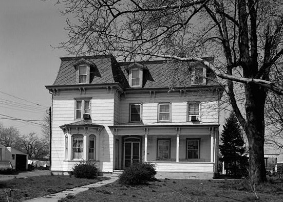
40°25′35″N 73°59′5″W / 40.42639°N 73.98472°WHighlands 32 T. Thomas Fortune House 
December 8, 1976 94 W. Bergen Pl.
40°20′29″N 74°4′26″W / 40.34139°N 74.07389°WRed Bank 33 Grover House October 10, 2002 940 W. Front St.
40°20′41″N 74°6′16″W / 40.34472°N 74.10444°WMiddletown 34 Murry Guggenheim House March 28, 1978 Cedar and Norwood Aves.
40°16′56″N 74°0′12″W / 40.28222°N 74.00333°WWest Long Branch 35 Hankinson-Moreau-Covenhoven House May 1, 1974 150 W. Main St.
40°15′7″N 74°17′19″W / 40.25194°N 74.28861°WFreehold 36 Holmdel Dutch Reformed Church October 22, 1980 41 Main St.
40°20′43″N 74°11′4″W / 40.34528°N 74.18444°WHolmdel 37 Holmes-Hendrickson House April 26, 1978 N of Holmdel
40°22′20″N 74°11′9″W / 40.37222°N 74.18583°WHolmdel 38 Holy Trinity Episcopal Church 
March 8, 1991 Jct. of Monmouth and Third Aves.
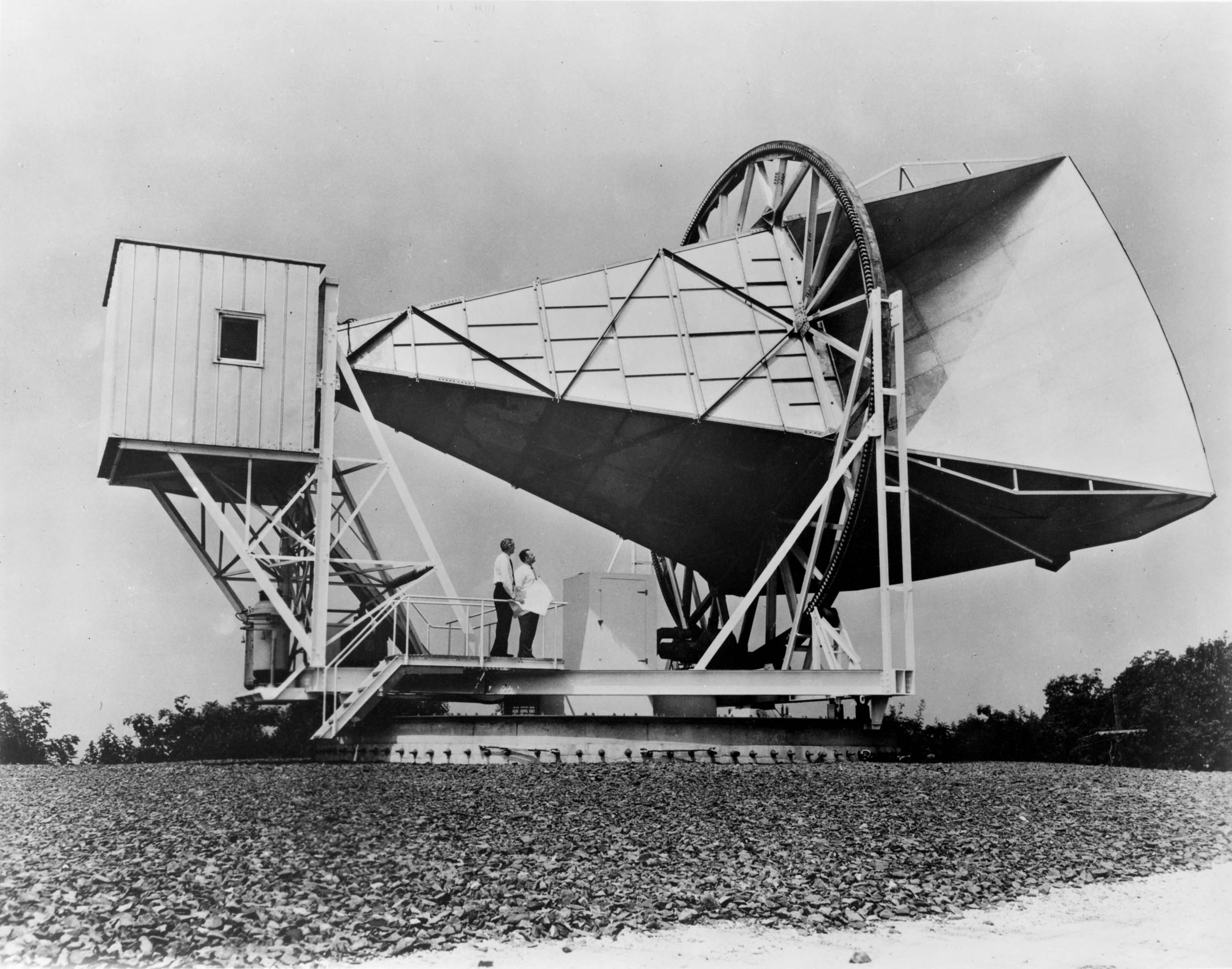
40°8′46″N 74°1′52″W / 40.14611°N 74.03111°WSpring Lake 39 Horn Antenna 
December 20, 1989 Off Garden State Parkway in Crawford Hill Facility
40°23′29″N 74°11′7″W / 40.39139°N 74.18528°WHolmdel 40 House at 364 Cedar Avenue November 1, 1979 364 Cedar Ave.
40°16′52″N 74°0′6″W / 40.28111°N 74.00167°WLong Branch 41 Imlaystown Historic District 
January 3, 1985 Roughly Imlaystown-Davis Station Rd., and Imlaystown-Red Valley Rd.
40°9′50″N 74°30′41″W / 40.16389°N 74.51139°WUpper Freehold Township 42 Jersey Homesteads Historic District December 5, 1983 All that area within the corporate boundaries of the Borough of Roosevelt
40°13′17″N 74°28′26″W / 40.22139°N 74.47389°WRoosevelt 43 Kovenhoven April 26, 1974 N of Holmdel off NJ 34
40°21′56″N 74°11′43″W / 40.36556°N 74.19528°WHolmdel 44 Lauriston March 8, 2002 Addriess Restricted Rumson 45 Little Silver Station 
June 22, 1984 Sycamore and Branch Aves.
40°19′35″N 74°2′28″W / 40.32639°N 74.04111°WLittle Silver 46 Longstreet Farm November 29, 1979 N of Holmdel on Longstreet Rd.
40°22′8″N 74°11′2″W / 40.36889°N 74.18389°WHolmdel 47 MacGregor-Tallman House September 5, 1985 407 Monmouth Rd.
40°16′52″N 74°1′9″W / 40.28111°N 74.01917°WWest Long Branch 48 Martin Maloney Cottage 
October 26, 1992 101 Morris Ave.
40°9′5″N 74°1′29″W / 40.15139°N 74.02472°WSpring Lake 49 Manasquan Friends Meetinghouse and Burying Ground July 22, 1992 NJ 35 at Manasquan Cir., Wall Township
40°7′58″N 74°3′53″W / 40.13278°N 74.06472°WManasquan 50 Matawan Station June 22, 1984 Between Main and Atlantic Aves.
40°25′12″N 74°13′27″W / 40.42°N 74.22417°WMatawan 51 Merino Hill House and Farm February 11, 1988 Allentown-Clarksburg Rd., CR 524
40°11′8″N 74°30′6″W / 40.18556°N 74.50167°WWrightsville 52 Middletown Village Historic District May 3, 1974 Irregular pattern--both sides of Kings Highway, S and W of NJ 35
40°23′36″N 74°6′47″W / 40.39333°N 74.11306°WMiddletown 53 Monmouth Battlefield 
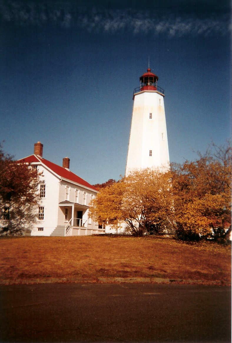
October 15, 1966 NW of Freehold on NJ 522, W of Rte. 9
40°16′23″N 74°18′50″W / 40.27306°N 74.31389°WFreehold 54 Monmouth Boat Club August 16, 1994 Union St. E of Boat Club Ct.
40°21′12″N 74°4′1″W / 40.35333°N 74.06694°WRed Bank 55 Navesink Historic District September 5, 1975 Roughly triangular area including both sides of Monmouth Ave. and Locust Ave. to junction with Hillside and Grand Aves.
40°24′2″N 74°2′3″W / 40.40056°N 74.03417°WNavesink 56 Navesink Light Station 
February 17, 2006 100 Government-Lighthouse Rd.
40°23′46.4″N 73°59′8.8″W / 40.396222°N 73.985778°WHighlands 57 North Long Branch School-Primary No. 3 July 28, 1999 469 Church St.
40°19′15″N 73°58′44″W / 40.32083°N 73.97889°WLong Branch 58 Ocean Grove Camp Meeting Association District April 12, 1976 Bounded by Fletcher Lake, NJ 71, Lake Wesley, and the Ocean
40°12′34″N 74°0′47″W / 40.20944°N 74.01306°WOcean Grove 59 Old Kentuck November 6, 1973 NW of Holmdel off NJ 34 on Pleasant Valley Rd.
40°21′56″N 74°13′14″W / 40.36556°N 74.22056°WHolmdel 60 Old Mill at Tinton Falls April 24, 1973 1205 Sycamore Ave.
40°18′16″N 74°6′3″W / 40.30444°N 74.10083°WTinton Falls 61 Old Scots Burying Ground August 15, 2001 Gordon's Corner Rd.
40°20′23″N 74°15′35″W / 40.33972°N 74.25972°WMarlboro 62 Palace Amusements November 22, 2000 201-207 Lake Ave.
40°13′4″N 74°0′13″W / 40.21778°N 74.00361°WAsbury Park Demolished in 2004 63 Probasco-Dittner Farmstead February 1, 2006 61 Bucks Mill Rd.
40°17′15″N 74°12′14″W / 40.2875°N 74.20389°WColts Neck 64 Anthony Reckless Estate June 3, 1982 164 Broad St.
40°20′47″N 74°3′58″W / 40.34639°N 74.06611°WRed Bank 65 Red Bank Passenger Station 
May 28, 1976 Ridge and Monmouth Sts.
40°20′52″N 74°4′30″W / 40.34778°N 74.075°WRed Bank 66 River Street School April 14, 1995 60 River St.
40°20′35″N 74°4′36″W / 40.34306°N 74.07667°WRed Bank 67 Romer Shoal Light Station 
January 24, 2007 In Lower New York Bay, 3.8 mi. N of Sandy Hook
40°30′46″N 74°0′50″W / 40.51278°N 74.01389°WHighlands Borough 68 Salter's Mill September 29, 1980 Imlaystown-Davis Station Rd.
40°9′54″N 74°30′51″W / 40.165°N 74.51417°WImlaystown 69 Sandy Hook Archeological Site June 26, 1998 Gateway National Recreation Area, Address Restricted Highlands 70 Sandy Hook Light 
October 15, 1966 Fort Hancock Military Reservation
40°27′42″N 74°0′9″W / 40.46167°N 74.0025°WSandy Hook 71 Seabright Lawn Tennis and Cricket Club 
July 9, 1991 Jct. of Rumson Rd. and Tennis Court Ln.
40°21′59″N 73°59′1″W / 40.36639°N 73.98361°WRumson 72 Seabrook-Wilson House October 29, 1974 119 Port Monmouth Rd.
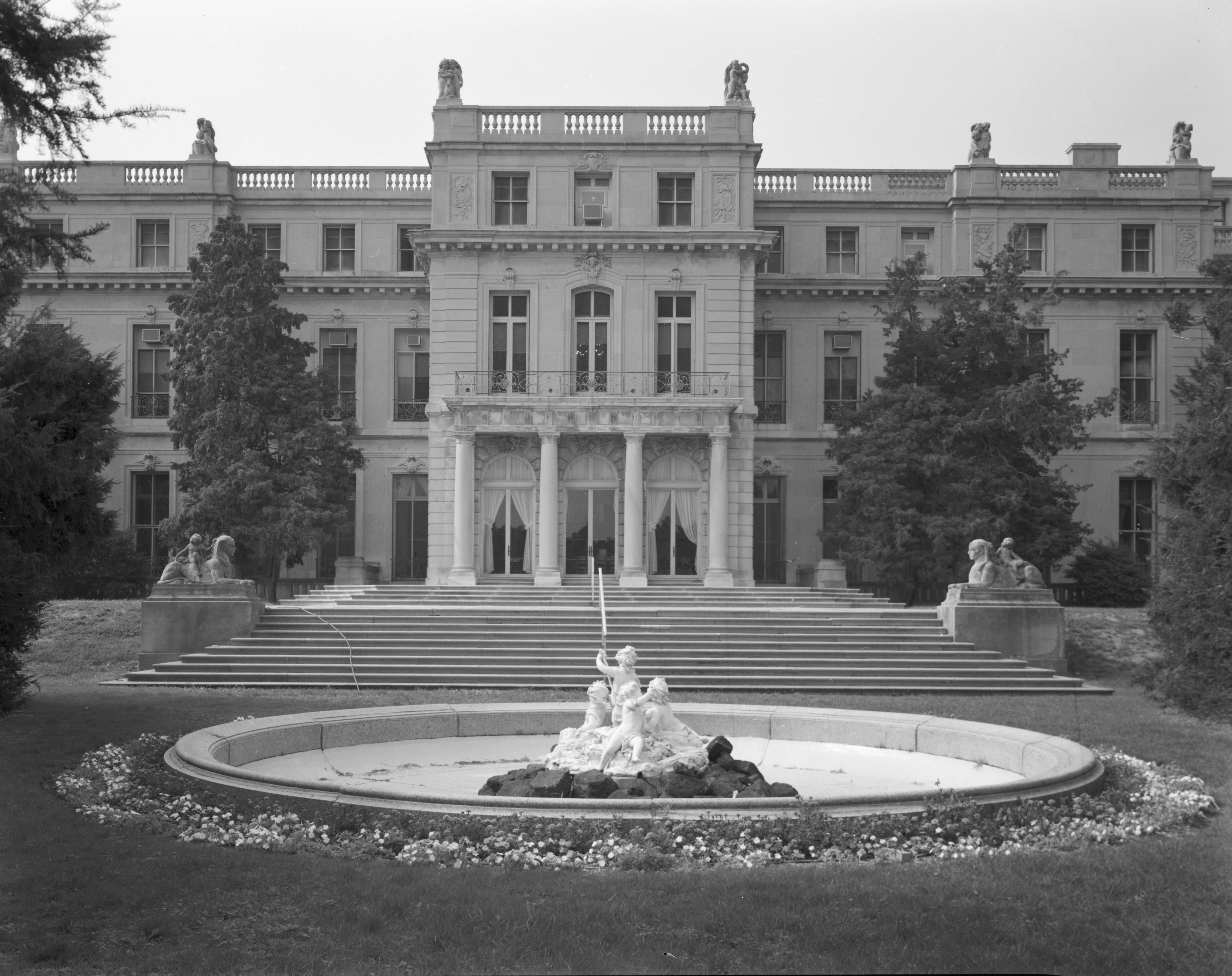
40°26′21″N 74°5′35″W / 40.43917°N 74.09306°WMiddletown 73 Shadow Lawn 
March 28, 1978 Cedar and Norwood Aves.
40°16′46″N 74°0′19″W / 40.27944°N 74.00528°WWest Long Branch 74 Shrewsbury Historic District July 17, 1978 Broad and Sycamore Sts.
40°19′23″N 74°3′49″W / 40.32306°N 74.06361°WShrewsbury 75 Shrewsbury Township Hall December 8, 1980 51 Monmouth St.
40°20′57″N 74°4′6″W / 40.34917°N 74.06833°WRed Bank 76 Squan Beach Life-Saving Station #9 March 5, 2008 Ocean & 2nd Aves.
40°7′3″N 74°2′2″W / 40.1175°N 74.03389°WManasquan 77 St. George's-by-the-River Episcopal Church February 13, 2007 7 Lincoln Ave.
40°21′48″N 73°58′43″W / 40.36333°N 73.97861°WRumson 78 St. James Memorial Church of Eatontown February 17, 1978 69 Broad St.
40°18′22″N 74°3′26″W / 40.30611°N 74.05722°WEatontown 79 St. John's Episcopal Church December 27, 1990 Little Silver Point Rd.
40°20′2″N 74°1′58″W / 40.33389°N 74.03278°WLittle Silver 80 St. Peter's Episcopal Church March 19, 1998 31 Throckmorton St.
40°15′34″N 74°16′34″W / 40.25944°N 74.27611°WFreehold Borough 81 Steinbach-Cookman Building July 8, 1982 Cookman Ave.
40°12′59″N 74°0′37″W / 40.21639°N 74.01028°WAsbury Park 82 George Taylor House April 29, 1994 74 Broadway
40°16′3″N 74°16′2″W / 40.2675°N 74.26722°WFreehold Borough 83 Tinton Falls Historic District November 10, 1977 Irregular pattern along Tinton and Sycamore Aves.
40°18′18″N 74°5′57″W / 40.305°N 74.09917°WTinton Falls 84 Twin Lights December 2, 1970 S of NJ 36 on a promontory between the Navesink River and Sandy Hook Bay
40°23′48″N 73°59′11″W / 40.39667°N 73.98639°WHighlands 85 Union Schoolhouse June 23, 1976 W of Red Bank on Middletown-Lincroft Rd.
40°21′57″N 74°7′14″W / 40.36583°N 74.12056°WRed Bank 86 Upper Freehold Baptist Meeting April 21, 1975 E of Imlaystown on Red Valley Rd.
40°10′8″N 74°28′28″W / 40.16889°N 74.47444°WImlaystown 87 Upper Meeting House of the Baptist Church of Middletown December 7, 1990 40 Main St.
40°20′41″N 74°11′11″W / 40.34472°N 74.18639°WHolmdel 88 Village Inn 
November 13, 1972 Water and Main Sts.
40°17′50″N 74°21′34″W / 40.29722°N 74.35944°WEnglishtown 89 Walker-Combs-Hartshorne Farmstead October 4, 1990 189 Wemrock Rd.
40°14′51″N 74°18′22″W / 40.2475°N 74.30611°WFreehold 90 Walnford 
June 29, 1976 S of Allentown off CR 539
40°8′3″N 74°33′32″W / 40.13417°N 74.55889°WAllentown 91 Wardell House July 24, 1974 419 Sycamore Ave.
40°19′22″N 74°3′46″W / 40.32278°N 74.06278°WShrewsbury 92 Water Witch Club Casino August 13, 1990 Jct. of E. Twin Rd. and W. Twin Rd.
40°24′0″N 73°59′39″W / 40.4°N 73.99417°WHighlands 93 Water Witch Club Historic District March 12, 2004 Roughly bounded by NJ 36, Water Wich Dr., Sea View Terrace, Park Way, Windlass Path and Serpentine Dr.
40°24′2″N 73°59′49″W / 40.40056°N 73.99694°WMiddletown Township 94 Winsor Building September 13, 1979 400-420 Main St. and 715-131 Bangs Ave
40°13′2″N 74°0′42″W / 40.21722°N 74.01167°WAsbury Park 95 George Wurts Summer Home December 28, 1989 306 Eighth Ave.
40°13′41″N 74°0′7″W / 40.22806°N 74.00194°WAsbury Park References
- ^ a b The latitude and longitude information provided in this table was derived originally from the National Register Information System, which has been found to be fairly accurate for about 99% of listings. For about 1% of NRIS original coordinates, experience has shown that one or both coordinates are typos or otherwise extremely far off; some corrections may have been made. A more subtle problem causes many locations to be off by up to 150 yards, depending on location in the country: most NRIS coordinates were derived from tracing out latitude and longitudes off of USGS topographical quadrant maps created under the North American Datum of 1927, which differs from the current, highly accurate WGS84 GPS system used by Google maps. Chicago is about right, but NRIS longitudes in Washington are higher by about 4.5 seconds, and are lower by about 2.0 seconds in Maine. Latitudes differ by about 1.0 second in Florida. Some locations in this table may have been corrected to current GPS standards.
- ^ "National Register of Historic Places: Weekly List Actions". National Park Service, United States Department of the Interior. Retrieved on November 10, 2011.
- ^ Numbers represent an ordering by significant words. Various colorings, defined here, differentiate National Historic Landmark sites, a [[National Historic Site (United States)|]], and several National Register of Historic Places Districts from other NRHP buildings, structures, sites or objects.
- ^ "National Register Information System". National Register of Historic Places. National Park Service. 2008-04-24. http://nrhp.focus.nps.gov/natreg/docs/All_Data.html.
U.S. National Register of Historic Places Topics Lists by states Alabama • Alaska • Arizona • Arkansas • California • Colorado • Connecticut • Delaware • Florida • Georgia • Hawaii • Idaho • Illinois • Indiana • Iowa • Kansas • Kentucky • Louisiana • Maine • Maryland • Massachusetts • Michigan • Minnesota • Mississippi • Missouri • Montana • Nebraska • Nevada • New Hampshire • New Jersey • New Mexico • New York • North Carolina • North Dakota • Ohio • Oklahoma • Oregon • Pennsylvania • Rhode Island • South Carolina • South Dakota • Tennessee • Texas • Utah • Vermont • Virginia • Washington • West Virginia • Wisconsin • WyomingLists by territories Lists by associated states Other  State of New Jersey
Topics Regions - Atlantic Coastal Plain
- Central Jersey
- Delaware River Region
- Delaware Valley
- Gateway Region
- Gold Coast
- Highlands
- Jersey Shore
- Meadowlands
- New York metro area
- North Hudson
- North Jersey
- Pascack Valley
- Piedmont
- Pine Barrens
- Raritan Bayshore
- Ridge-and-Valley Appalachians
- Southern Shore Region
- Skylands Region
- South Jersey
- Tri‑State Region
- West Hudson
Counties Major cities Categories:- National Register of Historic Places in New Jersey
- Monmouth County, New Jersey
-


Wikimedia Foundation. 2010.