- National Register of Historic Places listings in Sussex County, New Jersey
-
List of the National Register of Historic Places listings in Sussex County, New Jersey
Contents: Counties in New Jersey Atlantic - Bergen - Burlington - Camden - Cape May - Cumberland - Essex - Gloucester - Hudson - Hunterdon - Mercer - Middlesex - Monmouth - Morris - Ocean - Passaic - Salem - Somerset - Sussex - Union - Warren This is intended to be a complete list of properties and districts listed on the National Register of Historic Places in Sussex County, New Jersey. The locations of National Register properties and districts (at least for all showing latitude and longitude coordinates below) may be seen in a Google map by clicking on "Map of all coordinates".[1]
-
- This National Park Service list is complete through NPS recent listings posted November 10, 2011.[2]
[3] Site name[4] Image Date listed Location[1] City or Town Summary 1 Backwards Tunnel December 28, 2005 Cork Hill Rd., 310 ft. N of Passaic Ave. intersection
41°5′16″N 74°36′6″W / 41.08778°N 74.60167°WOgdensburg 2 Bethany Chapel February 29, 1980 103 Hamburg Tpke.
41°8′50″N 74°34′26″W / 41.14722°N 74.57389°WHamburg 3 Black Creek Site-28SX297 November 27, 2002 Address Restricted Vernon Township 4 Crescent Theatre September 7, 2005 74 Main St.
41°12′33″N 74°36′28″W / 41.20917°N 74.60778°WSussex 5 First Presbyterian Church of Wantage September 23, 1982 N of Sussex on NJ 23
41°14′28″N 74°37′22″W / 41.24111°N 74.62278°WSussex 6 Foster-Armstrong House July 23, 1979 N of Branchville on River Rd.
41°18′33″N 74°47′21″W / 41.30917°N 74.78917°WBranchville 7 Cornelius Gunn House July 23, 1979 SW of Wallpack Center on Ridge Rd.
41°9′7″N 74°54′3″W / 41.15194°N 74.90083°WWallpack Center 8 Harmony Hill United Methodist Church September 19, 1977 N of Stillwater on Fairview Lake Rd.
41°2′33″N 74°52′54″W / 41.0425°N 74.88167°WStillwater 9 High Breeze Farm 
July 27, 1989 Barrett Rd. off NJ 94
41°13′6″N 74°25′3″W / 41.21833°N 74.4175°WHighland Lakes 10 High Point Park Historic District 
April 23, 1996 Roughly bounded by the NJ-NY state line and Deckertown Tnpk. between NJ 23 and NJ 653, Wantage and Montague Townships
41°17′16″N 74°41′40″W / 41.28778°N 74.69444°WBranchville 11 Hill Memorial July 18, 1985 82 Main St.
41°3′24″N 74°45′17″W / 41.05667°N 74.75472°WNewton 12 Lawrence Mansion November 2, 1979 W of Hamburg on NJ 94
41°9′9″N 74°35′14″W / 41.1525°N 74.58722°WHamburg 13 Richard Layton House July 23, 1979 SW of Wallpack Center on Ridge Rd.
41°8′53″N 74°54′14″W / 41.14806°N 74.90389°WWallpack Center 14 Log Cabin and Farm August 24, 1977 N of Branchville on Mattison Ave.
41°11′40″N 74°44′33″W / 41.19444°N 74.7425°WBranchville 15 Meadowburn Farm August 9, 1993 Address Restricted Vernon 16 Henry W. Merriam House December 18, 1970 131 Main St.
41°3′10″N 74°45′20″W / 41.05278°N 74.75556°WNewton 17 Millville Historic and Archaeological District January 30, 1984 Address Restricted Millville 18 Minisink Archeological Site April 19, 1993 in the vicinity of Minisink Island
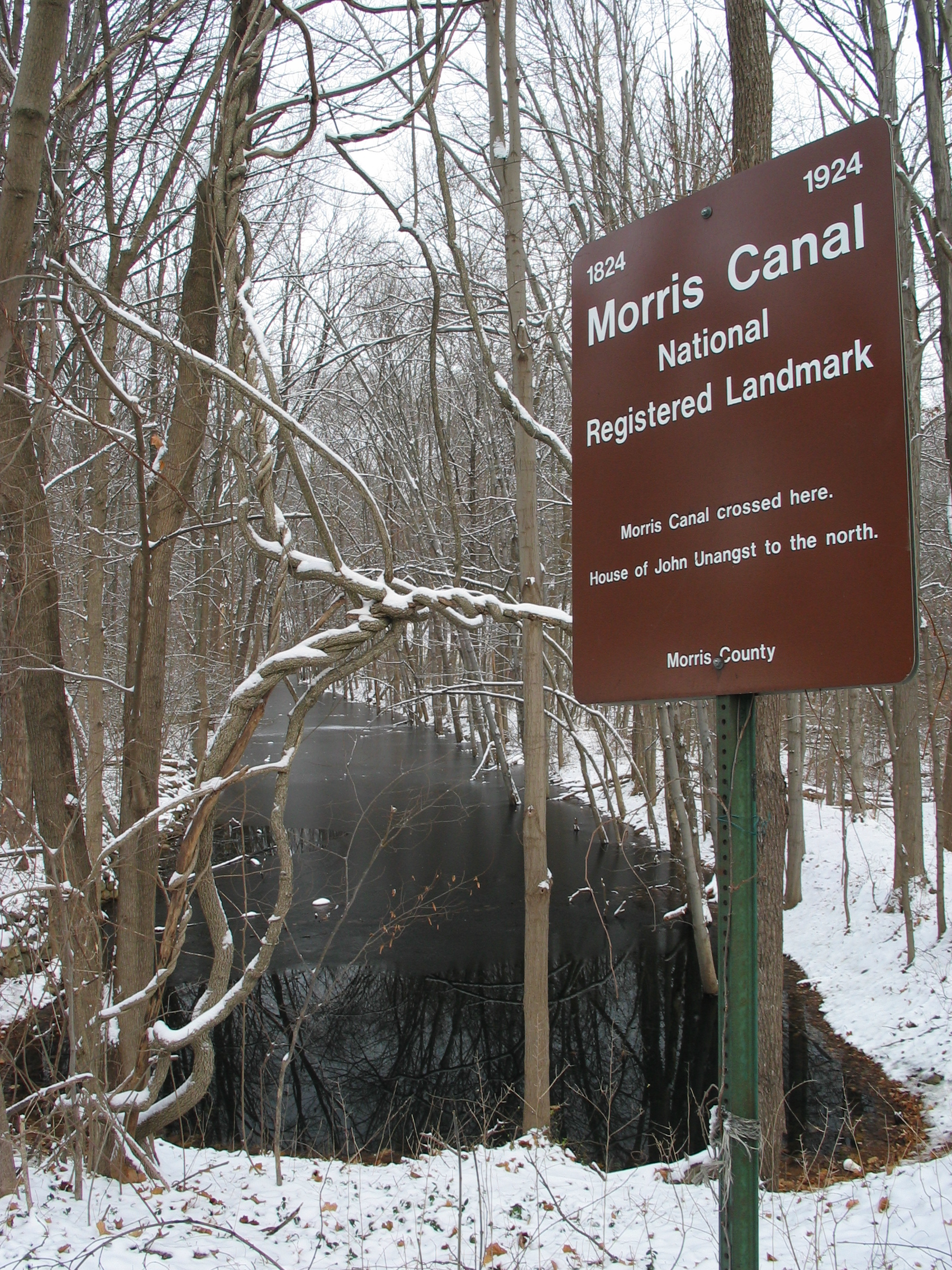
41°17′26.16″N 74°49′44.4″W / 41.2906°N 74.829°W[5]Millbrook 19 Morris Canal 
October 1, 1974 Irregular line beginning at Phillipsburg and ending at Jersey City
40°41′8″N 75°9′49″W / 40.68556°N 75.16361°WNot Applicable 20 Newton Town Plot Historic District November 12, 1992 Roughly, Church St., Park Pl. and Spring St. from Main St. to High St. and Main and High from Church to Spring
41°3′26″N 74°45′13″W / 41.05722°N 74.75361°WNewton 21 Old Mine Road Historic District December 3, 1980 NJ 521, Delaware, Old Mine, and River Rds.
41°9′15″N 74°55′4″W / 41.15417°N 74.91778°WWallpack Center 22 Old Monroe School House August 12, 1977 NJ 94
41°6′57″N 74°37′58″W / 41.11583°N 74.63278°WMonroe 23 Peters Valley Historic District February 29, 1980 Sandyston-Haney's Mill, Walpack, and Kuhn Rds.
41°11′46″N 74°51′12″W / 41.19611°N 74.85333°WWallpack Center 24 Plaster Mill August 3, 1977 Off Main St. and Kelly Pl.
40°54′6″N 74°42′30″W / 40.90167°N 74.70833°WStanhope 25 Casper and Abraham Shafer Grist Mill Complex December 10, 2009 928 Main St.
41°1′58.66″N 74°52′29.01″W / 41.0329611°N 74.874725°WStillwater New listing; refnum 09000653 26 Shoemaker-Houck Farm July 23, 1979 S of Wallpack Center on Heney's Mill-Wallpack Center Rd.
41°8′35″N 74°52′55″W / 41.14306°N 74.88194°WWallpack Center 27 Andrew Snable House July 23, 1979 NE of Wallpack Center on Sandyston-Haney's Mill Rd.
41°10′11″N 74°52′15″W / 41.16972°N 74.87083°WWallpack Center 28 Sterling Hill Mine 
September 3, 1991 30 Plant St.
41°4′59″N 74°36′24″W / 41.08306°N 74.60667°WOgdensburg 29 Stockholm United Methodist Church March 26, 1976 CR 515
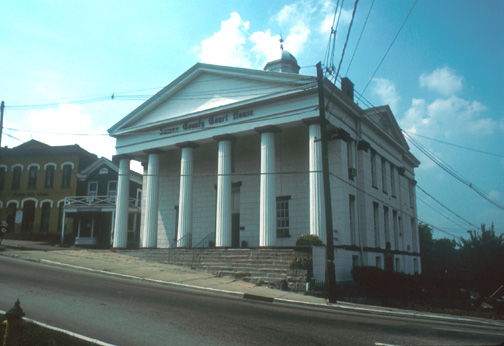
41°5′21″N 74°30′43″W / 41.08917°N 74.51194°WStockholm 30 Sussex County Courthouse 
July 23, 1979 High and Spring Sts.
41°3′32″N 74°45′14″W / 41.05889°N 74.75389°WNewton 31 Elias Van Bunschooten House November 1, 1974 NW of Sussex on NJ 23
41°15′51″N 74°38′11″W / 41.26417°N 74.63639°WSussex 32 Wallpack Center Historic District July 17, 1980 Wallpack Center Rd.
41°9′33″N 74°52′51″W / 41.15917°N 74.88083°WWallpack Center 33 Waterloo 
September 13, 1977 1 mi. S of Andover at Musconetcong River and CR 604
40°54′56″N 74°45′22″W / 40.91556°N 74.75611°WAndover 34 White Deer Plaza and Boardwalk District July 11, 1988 White Deer Plaza, Winona Pkwy., and W. Shore Trail
41°1′56″N 74°38′28″W / 41.03222°N 74.64111°WSparta 35 The Meadows December 4, 1973 1289 Easton Ave.
40°31′22″N 74°29′36″W / 40.52278°N 74.49333°WFranklin References
- ^ a b The latitude and longitude information provided in this table was derived originally from the National Register Information System, which has been found to be fairly accurate for about 99% of listings. For about 1% of NRIS original coordinates, experience has shown that one or both coordinates are typos or otherwise extremely far off; some corrections may have been made. A more subtle problem causes many locations to be off by up to 150 yards, depending on location in the country: most NRIS coordinates were derived from tracing out latitude and longitudes off of USGS topographical quadrant maps created under North American Datum of 1927, which differs from the current, highly accurate GPS system used by Google maps. Chicago is about right, but NRIS longitudes in Washington are higher by about 4.5 seconds, and are lower by about 2.0 seconds in Maine. Latitudes differ by about 1.0 second in Florida. Some locations in this table may have been corrected to current GPS standards.
- ^ "National Register of Historic Places: Weekly List Actions". National Park Service, United States Department of the Interior. Retrieved on November 10, 2011.
- ^ Numbers represent an ordering by significant words. Various colorings, defined here, differentiate National Historic Landmark sites, a [[National Historic Site (United States)|]], and several National Register of Historic Places Districts from other NRHP buildings, structures, sites or objects.
- ^ "National Register Information System". National Register of Historic Places. National Park Service. 2008-04-24. http://nrhp.focus.nps.gov/natreg/docs/All_Data.html.
- ^ Location derived from its NRHP nomination form; the NRIS lists the site as "Address Restricted"
U.S. National Register of Historic Places Topics Lists by states Alabama • Alaska • Arizona • Arkansas • California • Colorado • Connecticut • Delaware • Florida • Georgia • Hawaii • Idaho • Illinois • Indiana • Iowa • Kansas • Kentucky • Louisiana • Maine • Maryland • Massachusetts • Michigan • Minnesota • Mississippi • Missouri • Montana • Nebraska • Nevada • New Hampshire • New Jersey • New Mexico • New York • North Carolina • North Dakota • Ohio • Oklahoma • Oregon • Pennsylvania • Rhode Island • South Carolina • South Dakota • Tennessee • Texas • Utah • Vermont • Virginia • Washington • West Virginia • Wisconsin • WyomingLists by territories Lists by associated states Other  Category:National Register of Historic Places •
  Portal:National Register of Historic Places
 State of New Jersey
Trenton (capital) Topics Delegations · Demographics · Economy · Elections · Geography · Government · History · Media · Municipalities · Music · People · Politics · Symbols · Transportation · Parks
Regions Atlantic Coastal Plain · Central Jersey · Delaware River Region · Delaware Valley · Gateway Region · Gold Coast · Highlands · Jersey Shore · Meadowlands · New York metro area · North Hudson · North Jersey · Pascack Valley · Piedmont · Pine Barrens · Raritan Bayshore · Ridge-and-Valley Appalachians · Southern Shore Region · Skylands Region · South Jersey · Tri‑State Region · West Hudson
Counties Major cities Atlantic City · Camden · Edison · Elizabeth · Hackensack · Jersey City · Newark · New Brunswick · Ocean City · Paterson · Trenton · Vineland
Categories:- National Register of Historic Places in New Jersey
- Sussex County, New Jersey
-


Wikimedia Foundation. 2010.