- Denver–Aurora Metropolitan Area
-
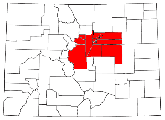
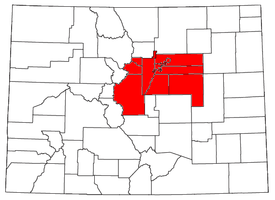 Location of the Denver-Aurora, CO Metropolitan Statistical Area
 Satellite image of the core of the Denver-Aurora, CO Metropolitan Statistical Area
The Denver-Aurora Metropolitan Statistical Area is a United States Census Bureau defined Metropolitan Statistical Area (MSA) in the State of Colorado that includes the City and County of Denver, City of Aurora, and nine suburban counties. The Census Bureau estimates that the population was 2,357,404 on 2007-07-01, an +14.23% increase since United States Census 2000.[1] In 2007, 50.7% of Coloradans lived in the Denver-Aurora MSA.
The Denver-Aurora MSA, the Boulder MSA, and the Greeley MSA comprise the larger Denver-Aurora-Boulder Combined Statistical Area. Local residents generally use the term Denver area or Denver metro area which may informally mean anything from the continuously urbanized area within the six central counties of the MSA to the Front Range Urban Corridor north of Colorado Springs and south of Fort Collins.
The central part of the MSA includes the City and County of Denver and its three immediately adjoining counties: Jefferson County to the west, Adams County to the north and east, and Arapahoe County to the south and east. The continuously urbanized area extends northwest into Broomfield County, bordering Jefferson and Adams counties, and south into Douglas County, adjoining Arapahoe County. The most prosperous parts of the area are in the south, while the most industrialized areas are in the northeast, specifically in the northern part of Denver proper and extending to areas such as Commerce City in Adams County.
Also included in the MSA defined by the United States Census Bureau are four rural counties that are not popularly considered part of the Denver metro area. Elbert County is on the southeastern prairie; Clear Creek, Gilpin, and Park counties are in the Rocky Mountains.
Although the counties, cities, and towns are self-governing, there is some cooperation in the metropolitan area. The Denver Regional Council of Governments (DRCOG, pronounced Doctor Cog) is a regional planning and inter-governmental coordination organization in a nine-county region. The Scientific and Cultural Facilities District (SCFD) provides funding for scientific and cultural facilities in a seven-county region including:
- The Denver Museum of Nature and Science
- The Denver Zoo
- The Denver Art Museum
- The Denver Center for the Performing Arts
- The Denver Botanic Gardens
In addition, the Regional Transportation District (RTD) provides mass transit, including a light rail system. In 2005 the RTD developed a twelve-year comprehensive plan, called "FasTracks", to build and operate rail transit lines and expand and improve bus service throughout the region.
The center of the metropolitan area sits in a valley, the Denver Basin, and suffers from air pollution known colloquially as the brown cloud, building up if the air is stagnant as it often is in the winter. Severity of pollution in this area has varied enormously over the years. In the late 1980s the area was frequently in violation of multiple National Ambient Air Quality Standards established by the United States Environmental Protection Agency (EPA). The Regional Air Quality Council (RAQC) was formed in 1989 to create plans to address the problem. Through a variety of measures the area's air quality was improved and in 2002 the EPA designated the area in compliance with all federal health-based air quality standards. Denver was the first major city in the United States to reach compliance with all six of these standards after previously violating five of them[2]. Since then the EPA introduced a new standard for small particulates and made the existing ozone standard stricter. In 2003 the new ozone standard was frequently exceeded in the area and was occasionally exceeded as far away as Rocky Mountain National Park. The RAQC hopes to implement plans enabling the area to comply with the new standards by 2007.
Contents
Counties
The Denver-Aurora-Broomfield Metropolitan Statistical Area comprises ten counties.[2] The sortable table below includes the following information:
- The name of the county
- The population of the county as of 2007-07-01, as estimated by the United States Census Bureau[1]
- The county population as of 2000-04-01, as counted by the United States Census 2000[1]
- The percent county population change from 2000-04-01, to 2007-07-01, as estimated by the United States Census Bureau[1]
Denver-Aurora Metropolitan Statistical Area County 2007 Pop 2000 Pop Δ Pop City and County of Denver, Colorado 588,349 554,636 +6.08% Arapahoe County, Colorado 545,089 487,967 +11.71% Jefferson County, Colorado 529,354 527,056 +0.44% Adams County, Colorado 422,495 363,857 +16.12% Douglas County, Colorado 272,117 175,766 +54.82% City and County of Broomfield, Colorado 53,691 0 NA Elbert County, Colorado 22,720 19,872 +14.33% Park County, Colorado 17,004 14,523 +17.08% Clear Creek County, Colorado 8,956 9,322 -3.93% Gilpin County, Colorado 5,091 4,757 +7.02% Total 2,464,866 2,157,756 +14.23% Metropolitan Area Cities and Towns
Places with over 100,000 inhabitants
Places with 10,000 to 100,000 inhabitants
- Berkley (CDP)
- Brighton
- Broomfield
- Castle Rock
- Centennial
- Columbine (CDP)
- Commerce City
- Englewood
- Federal Heights
- Golden
- Greenwood Village
- Highlands Ranch (CDP)
- Ken Caryl (CDP)
- Littleton
- Northglenn
- Parker
- Sherrelwood (CDP)
- Welby (CDP)
- Wheat Ridge
Places with fewer than 10,000 inhabitants
- Acres Green (CDP)
- Applewood (CDP)
- Alma
- Aspen Park (CDP)
- Bennett (CDP)
- Bow Mar
- Black Hawk
- Byers (CDP)
- Carriage Club (CDP)
- Castle Pines (CDP)
- Castle Pines North
- Central City
- Cherry Hills Village
- Coal Creek
- Columbine Valley
- Cottonwood (CDP)
- Deer Trail
- Derby (CDP)
- Downieville-Lawson-Dumont
- East Pleasant View (CDP)
- Edgewater
- Elizabeth
- Empire
- Evergreen (CDP)
- Fairplay
- Foxfield
- Franktown (CDP)
- Genesee (CDP)
- Georgetown
- Glendale
- Grand View Estates (CDP)
- Heritage Hills (CDP)
- Idaho Springs
- Indian Hills (CDP)
- Kiowa
- Kittredge (CDP)
- Lakeside
- Larkspur
- Lochbuie
- Lone Tree
- Louviers (CDP)
- Meridian (CDP)
- Morrison
- Mountain View
- North Washington (CDP)
- Perry Park (CDP)
- Ponderosa Park (CDP)
- Roxborough Park (CDP)
- Sedalia (CDP)
- Sheridan
- Silver Plume
- Simla
- St. Mary's
- Stonegate (CDP)
- Strasburg (CDP)
- The Pinery (CDP)
- Todd Creek (CDP)
- Twin Lakes (CDP)
- Westcreek (CDP)
- West Pleasant View (CDP)
Communities previously part of the Denver Metro Area
Former Denver Metro communities now part of the separate Boulder Metropolitan Area due to being located in Boulder County
Former Denver Metro communities now part of the separate Greeley Metropolitan Area due to being located in southwestern Weld County
Sister cities
Though Arvada, Aurora, Boulder, Brighton, Broomfield, Denver, Lakewood and Longmont have their own individual sister city relationships, the Denver Regional Council of Governments (DRCOG) as a whole has a sister city relationship with the
 Baghdad Governorate of Iraq.[3]
See also
 United States census statistical areas by state, district, or territoryASMPGUVI
- Colorado census statistical areas
- Combined Statistical Area
- Core Based Statistical Area
- Metropolitan Statistical Area
- Micropolitan Statistical Area
- Table of United States Combined Statistical Areas
- Table of United States Metropolitan Statistical Areas
- Table of United States Micropolitan Statistical Areas
- Table of United States primary census statistical areas
- Larger urban regions that contain the Denver-Aurora-Broomfield, CO Metropolitan Statistical Area:
- Core Based Statistical Areas adjacent to Denver-Aurora-Broomfield, CO Metropolitan Statistical Area:
- Other definitions of Colorado urban areas:
- Colorado metropolitan areas
- Denver Metropolitan Area
References
- ^ a b c d "Annual County Population Estimates and Estimated Components of Change: April 1, 2000 to July 1, 2007 (CO-EST2007-alldata)" (CSV). 2007 Population Estimates. United States Census Bureau, Population Division. 2008-03-20. http://www.census.gov/popest/counties/files/CO-EST2007-ALLDATA.csv. Retrieved 2008-03-25.
- ^ "Annual Estimates of the Population of Metropolitan and Micropolitan Statistical Areas: April 1, 2000 to July 1, 2007" (CSV). 2007 Population Estimates. United States Census Bureau, Population Division. 2008-03-27. http://www.census.gov/population/estimates/metro_general/2007/CBSA-EST2007-alldata.csv. Retrieved 2008-03-27.
- ^ [1]
External links
- Denver Regional Council of Governments
- International Migration
- Regional Air Quality Council
- Regional Transportation District
- Science & Cultural Facilities District
- United States Census Bureau
Categories:- Geography of Denver, Colorado
- Denver metropolitan area
- Metropolitan areas of Colorado
- Geography of Aurora, Colorado

Wikimedia Foundation. 2010.