North Central Colorado Urban Area

North Central Colorado Urban Area
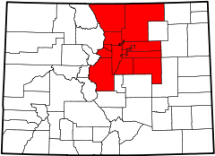
An enlargeable map of the 13-county North Central Colorado Urban Area

The North Central Colorado Urban Area comprises the four contiguous metropolitan statistical areas in the north central region of the State of Colorado: the Denver-Aurora Metropolitan Statistical Area, the Boulder Metropolitan Statistical Area, the Fort Collins-Loveland Metropolitan Statistical Area, and the Greeley Metropolitan Statistical Area. With the exception of southeastern Elbert County, southeastern Park County, and tiny portions of southern Douglas County, the entire North Central Colorado Urban Area is drained by the South Platte River and its tributaries. The North Central Colorado Urban Area is the central, and the most populous, of the three primary subregions of the Front Range Urban Corridor.

The North Central Colorado Urban Area had a population of 3,390,504 at the 2010 United States Census, a 17.67% increase from the 2000 United States Census.[1] In 2010, 67.42% of Coloradans lived in the North Central Colorado Urban Area.

Contents

Extent

The North Central Colorado Urban Area[1]

Core Based Statistical Area 2010 Census County 2010 Census 2000 Census Pop Change
Denver-Aurora-Broomfield, CO MSA 2,543,482 City and County of Denver, Colorado !B9866950517671 600,158 !B9867739326782 554,636 !D0025001163171 +8.21%
Arapahoe County, Colorado !B9867431004848 572,003 !B9869019969404 487,967 !D0017590025021 +17.22%
Jefferson County, Colorado !B9868108325447 534,543 !B9868249379162 527,056 !D0042541386215 +1.42%
Adams County, Colorado !B9870018334325 441,603 !B9871954837877 363,857 !D0015433138305 +21.37%
Douglas County, Colorado !B9874381252913 285,465 !B9879230911560 175,766 !D0004714133134 +62.41%
City and County of Broomfield, Colorado !B9890688771401 55,889 !F 0 !O NA
Elbert County, Colorado !B9899530183478 23,086 !B9901029330152 19,872 !D0018217954384 +16.17%
Park County, Colorado !B9903068631769 16,206 !B9904165111213 14,523 !D0021551556844 +11.59%
Clear Creek County, Colorado !B9908852898590 9,088 !B9908598675230 9,322 !H9963151886384 −2.51%
Gilpin County, Colorado !B9913982818535 5,441 !B9915326275035 4,757 !D0019394145788 +14.38%
Fort Collins-Loveland, CO MSA 299,630 Larimer County, Colorado !B9873896963408 299,630 !B9875648255886 251,494 !D0016533887944 +19.14%
Boulder, CO MSA 294,567 Boulder County, Colorado !B9874067382395 294,567 !B9874179322525 291,288 !D0044867739706 +1.13%
Greeley, CO MSA 252,825 Weld County, Colorado !B9875595471712 252,825 !B9878941013434 180,936 !D0009230201148 +39.73%
Total !B9849635108591 3,390,504 !B9851261874732 2,881,474 !D0017335502938 +17.67%

Constituent jurisdictions

The North Central Colorado Urban Area comprises:


See also

References


Wikimedia Foundation. 2010.

Игры ⚽ Поможем написать курсовую

Look at other dictionaries:

  • South Central Colorado Urban Area — The South Central Colorado Urban Area encompasses the Colorado Springs Metropolitan Statistical Area, the Pueblo Metropolitan Statistical Area, and the Cañon City Micropolitan Statistical Area in the central and south central region of the State… …   Wikipedia

  • Colorado metropolitan areas — Adams Alam Arapahoe …   Wikipedia

  • Colorado Springs Metropolitan Statistical Area — Map of the Colorado Springs Metropolitan Statistical Area The Colorado Springs Metropolitan Statistical Area is a United States Census Bureau defined Metropolitan Statistical Area (MSA) located in the Colorado Springs region of the State of… …   Wikipedia

  • Colorado Springs, Colorado —   City   Colorado Springs with the Front Range in background …   Wikipedia

  • Denver, Colorado — Infobox Settlement official name = City and County of Denver other name = native name = nickname = The Mile High City, Queen City of the Plains, The 303, D Town settlement type = City and County motto = imagesize = image caption = flag size =… …   Wikipedia

  • Denver-Aurora-Broomfield, CO Metropolitan Statistical Area — Location of the Denver Aurora Broomfield, CO Metropolitan Statistical Area …   Wikipedia

  • Denver–Aurora Metropolitan Area — Location of the Denver Aurora, CO Metropolitan Statistical Area …   Wikipedia

  • Boulder, Colorado — Infobox Settlement official name = Boulder, Colorado other name = native name = nickname = settlement type = City motto = imagesize = image caption = flag size = image seal size = image shield = shield size = image blank emblem = blank emblem… …   Wikipedia

  • Golden, Colorado — Infobox Settlement official name = City of Golden, Colorado other name = native name = nickname = settlement type = City motto = Where the West Lives imagesize = 250 px image caption = Washington Avenue in downtown Golden flag size = image seal… …   Wikipedia

  • Front Range Urban Corridor — The Front Range Urban Corridor is an oblong region of urban population located along the eastern face of the Southern Rocky Mountains in the U.S. states of Colorado and Wyoming. The United States Census Bureau estimates that the Front Range Urban …   Wikipedia

Share the article and excerpts

Direct link
Do a right-click on the link above
and select “Copy Link”