- Pierce, Colorado
Infobox Settlement
elevation_footnotes = GR|3
established_title = Founded
established_title2 = Incorporated (town)
established_date2 =August 30 ,1918 cite web | url = http://www.colorado.gov/dpa/doit/archives/muninc.html | title = Colorado Municipal Incorporations | format =HTML | publisher = State of Colorado, Department of Personnel & Administration, Colorado State Archives | date =2004-12-01 | accessdate = 2007-09-02]
pushpin_
official_name = Town of Pierce, Colorado
settlement_type =Town
nickname =
motto =
postal_code_type =ZIP code cite web | url = http://zip4.usps.com/zip4/citytown.jsp | title = ZIP Code Lookup| format =JavaScript /HTML | publisher =United States Postal Service | accessdate = December 14 | accessyear = 2007]
postal_code = 80650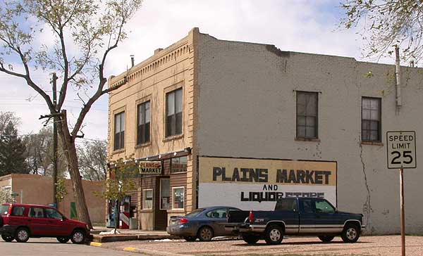
imagesize =
image_caption = Grocery store on Main Street in Pierce, Colorado
image_
image_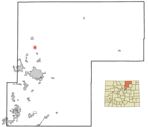
mapsize = 250px
map_caption = Location of Pierce shown withinColorado
mapsize1 =
map_caption1 =
subdivision_type = Country
subdivision_name = USA
subdivision_type1 = State
subdivision_name1 = flag|Colorado
subdivision_type2 = Countycite web | url = http://www.dola.state.co.us/dlg/local_governments/municipalities.html | title = Active Colorado Municipalities | format =HTML | publisher = State of Colorado, Department of Local Affairs | accessdate = 2007-09-01]
subdivision_name2 = Weld
government_type = Statutory Town
leader_title =Mayor
leader_name = Craig Cleveland
leader_title1 =
leader_name1 =
established_title1 =
established_date1 =
established_date = 1869
area_magnitude =
area_total_km2 = 1.9
area_total_sq_mi = 0.7
area_land_km2 = 1.9
area_land_sq_mi = 0.7
area_water_km2 = 0.0
area_water_sq_mi = 0.0
area_water_percent = 0.0
area_urban_km2 =
area_urban_sq_mi =
area_metro_km2 =
area_metro_sq_mi =
population_as_of = 2000
population_note =
population_total = 884
population_density_km2 = 462.8
population_density_sq_mi = 1,198.7
population_metro =
population_density_metro_km2 =
population_density_metro_sq_mi =
population_urban =
timezone = MST
utc_offset = -7
timezone_DST = MDT
utc_offset_DST = -6
latd = 40 |latm = 38 |lats = 6 |latNS = N
longd = 104 |longm = 45 |longs = 16 |longEW = W
elevation_m = 1534
elevation_ft = 5033
website =
area_code = 970
blank_name = FIPS code
blank_info = 08-59005
blank1_name = GNIS feature ID
blank1_info = [http://geonames.usgs.gov/pls/gnispublic/f?p=gnispq:3:::NO::P3_FID:0202703 0202703]
footnotes =Pierce is a Statutory Town in Weld County,
Colorado ,United States . The population was 884 at the 2000 census. The town is a rural agricultural community located on theColorado Eastern Plains alongU.S. Highway 85 north of Greeley. It was founded in 1869 and incorporated in 1918. It was named in honor of John Pierce, then president of theUnion Pacific Railroad , in anticipation of the construction of an extension of the Union Pacific line southward into Colorado. The following year in 1870 it became a watering stop forsteam locomotive s on the newly builtDenver Pacific Railroad . A box car was used as the first town post office, depot, and telegraph office. A depot was constructed in 1905 and demolished in 1963. As a railroad stop, it became a local shipping point forcattle ,sheep ,potato es, beans, andsugar beet s. The town underwent a decline in population (from 1,000 in 1976) and its economic base during the latter 20th century with the construction of highways that allowed more direct shipping of agricultural products. The town today consists of a small grid of gravel streets, with one paved thoroughfare (Main Street) west of U.S. Highway 85. The principal businesses in town include agrain elevator , as well as a grocery store, tavern, and other businesses along Main Street. The town also has a school, a volunteer fire station, a church, and a town park.Geography
Pierce is located at coor dms|40|38|6|N|104|45|16|W|city (40.635134, -104.754574)GR|1.
According to the
United States Census Bureau , the town has a total area of 0.7 square miles (1.9 km²), all of it land.Demographics
As of the
census GR|2 of 2000, there were 884 people, 312 households, and 249 families residing in the town. Thepopulation density was 1,198.7 people per square mile (461.2/km²). There were 318 housing units at an average density of 431.2/sq mi (165.9/km²). The racial makeup of the town was 86.99% White, 0.45% Native American, 0.79% Asian, 0.11% Pacific Islander, 9.73% from other races, and 1.92% from two or more races. Hispanic or Latino of any race were 20.48% of the population.There were 312 households out of which 39.4% had children under the age of 18 living with them, 62.8% were married couples living together, 11.5% had a female householder with no husband present, and 19.9% were non-families. 17.0% of all households were made up of individuals and 4.8% had someone living alone who was 65 years of age or older. The average household size was 2.83 and the average family size was 3.15.
In the town the population was spread out with 30.4% under the age of 18, 7.7% from 18 to 24, 31.9% from 25 to 44, 19.0% from 45 to 64, and 11.0% who were 65 years of age or older. The median age was 35 years. For every 100 females there were 102.3 males. For every 100 females age 18 and over, there were 99.7 males.
The median income for a household in the town was $36,944, and the median income for a family was $44,265. Males had a median income of $33,611 versus $22,174 for females. The
per capita income for the town was $17,412. About 4.6% of families and 6.9% of the population were below thepoverty line , including 9.0% of those under age 18 and 10.4% of those age 65 or over.In Popular Culture
* The opening scene of the 2000 science fiction film
Titan A.E. takes place in Pierce, Colorado.ee also
*
Colorado municipalities
*Denver-Aurora-Boulder Combined Statistical Area
*Front Range Urban Corridor
*Greeley Metropolitan Statistical Area
*State of Colorado
*Weld County, Colorado ee also
*
State of Colorado
**Colorado cities and towns
***Colorado municipalities
**Colorado counties
***Weld County, Colorado References
External links
* [http://www.cmca.gen.co.us/Municipality.cfm?MunicipalityID=149 Town of Pierce contacts]
** [http://www.dot.state.co.us/App_DTD_DataAccess/Downloads/CityMaps/Pierce.pdf CDOT map of the Town of Pierce]
Wikimedia Foundation. 2010.