- Dacono, Colorado
-
City of Dacono, Colorado — City — Location in Weld County and the State of Colorado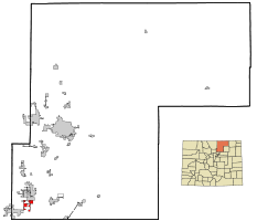
Coordinates: 40°4′33″N 104°56′43″W / 40.07583°N 104.94528°WCoordinates: 40°4′33″N 104°56′43″W / 40.07583°N 104.94528°W Country  United States
State  State of Colorado
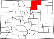
County Weld County[1] Incorporated September 23, 1908[2] Government – Type Home Rule Municipality[1] Area – Total 2.7 sq mi (7.1 km2) – Land 2.7 sq mi (7.1 km2) – Water 0 sq mi (0 km2) Elevation[3] 5,030 ft (1,533 m) Population (2000) – Total 3,015 – Density 1,116.7/sq mi (424.6/km2) Time zone MST (UTC-7) – Summer (DST) MDT (UTC-6) ZIP code[4] 80514 Area code(s) 303 FIPS code 08-19080 GNIS feature ID 0180837 Website City of Dacono The City of Dacono is a Home Rule Municipality located in Weld County, Colorado, United States. The population was 3,015 at the 2000 census.
Contents
History
The city name was coined from the first names of three local residents: Daisy Baum, Cora Van Vorhies and Nona (or Nora) Brooks.[5]
Geography
Dacono is located at 40°4′33″N 104°56′43″W / 40.07583°N 104.94528°W (40.075772, -104.945353)[6].
According to the United States Census Bureau, the city has a total area of 2.7 square miles (7.0 km2), of which, 2.7 square miles (7.0 km2) of it is land and 0.37% is water.
Demographics
As of the census[7] of 2000, there were 3,015 people, 1,087 households, and 756 families residing in the city. The population density was 1,103.0 people per square mile (426.4/km²). There were 1,136 housing units at an average density of 415.6 per square mile (160.7/km²). The racial makeup of the city was 77.05% White, 0.43% African American, 0.96% Native American, 1.00% Asian, 17.98% from other races, and 2.59% from two or more races. Hispanic or Latino of any race were 32.04% of the population.
There were 1,087 households out of which 34.6% had children under the age of 18 living with them, 55.3% were married couples living together, 9.3% had a female householder with no husband present, and 30.4% were non-families. 23.6% of all households were made up of individuals and 7.6% had someone living alone who was 65 years of age or older. The average household size was 2.77 and the average family size was 3.32.
In the city the population was spread out with 29.2% under the age of 18, 7.9% from 18 to 24, 32.4% from 25 to 44, 21.2% from 45 to 64, and 9.3% who were 65 years of age or older. The median age was 33 years. For every 100 females there were 100.2 males. For every 100 females age 18 and over, there were 99.3 males.
The median income for a household in the city was $38,854, and the median income for a family was $42,659. Males had a median income of $29,899 versus $25,000 for females. The per capita income for the city was $15,368. About 3.6% of families and 6.0% of the population were below the poverty line, including 6.5% of those under age 18 and 6.4% of those age 65 or over.
See also
- Colorado municipalities
- Denver-Aurora-Boulder Combined Statistical Area
- Front Range Urban Corridor
- Greeley Metropolitan Statistical Area
- State of Colorado
- Weld County, Colorado
References
- ^ a b "Active Colorado Municipalities". State of Colorado, Department of Local Affairs. http://www.dola.state.co.us/dlg/local_governments/municipalities.html. Retrieved 2007-09-01.
- ^ "Colorado Municipal Incorporations". State of Colorado, Department of Personnel & Administration, Colorado State Archives. 2004-12-01. http://www.colorado.gov/dpa/doit/archives/muninc.html. Retrieved 2007-09-02.
- ^ "US Board on Geographic Names". United States Geological Survey. 2007-10-25. http://geonames.usgs.gov. Retrieved 2008-01-31.
- ^ "ZIP Code Lookup" (JavaScript/HTML). United States Postal Service. http://zip4.usps.com/zip4/citytown.jsp. Retrieved September 6, 2007.
- ^ "Profile for Dacono, Colorado". ePodunk. http://www.epodunk.com/cgi-bin/genInfo.php?locIndex=9421. Retrieved 2010-06-16.
- ^ "US Gazetteer files: 2010, 2000, and 1990". United States Census Bureau. 2011-02-12. http://www.census.gov/geo/www/gazetteer/gazette.html. Retrieved 2011-04-23.
- ^ "American FactFinder". United States Census Bureau. http://factfinder.census.gov. Retrieved 2008-01-31.
External links
- City of Dacono website
- Carbon Valley Edition of the Longmont Times-Call (Local news, information & advertising)
Municipalities and communities of Weld County, Colorado Cities Brighton‡ | Dacono | Evans | Fort Lupton | Greeley | Longmont‡ | Northglenn‡ | Thornton‡
Towns CDP Unincorporated
communitiesAdna | Auburn | Briggsdale | Carr | Galeton | Gill | Hereford | Highlandlake | Lucerne | Prospect Valley | Roggen | Stoneham | Tampa | Wattenburg
Ghost towns Footnotes ‡This populated place also has portions in an adjacent county or counties
Categories:- Populated places in Weld County, Colorado
- Cities in Colorado


Wikimedia Foundation. 2010.