- Laramie County, Wyoming
-
Laramie County, Wyoming 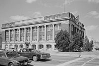 City and County Building in Cheyenne
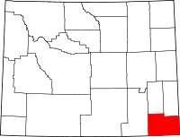
Location in the state of Wyoming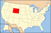
Wyoming's location in the U.S.Founded 1867 Seat Cheyenne Largest city Cheyenne Area
- Total
- Land
- Water
2,688 sq mi (6,962 km²)
2,686 sq mi (6,957 km²)
2 sq mi (5 km²), 0.06%Population
- (2010)
- Density
91,738
34/sq mi (13/km²)Time zone Mountain: UTC-7/-6 Website webgate.co.laramie.wy.us Laramie County is the most populous of the 23 counties of the U.S. state of Wyoming. The county is located in the southeastern corner of the state. The county's population was 91,738 at the 2010 census.[1] The county seat is Cheyenne, the state capital.[2] The Cheyenne, Wyoming, Metropolitan Statistical Area comprises Laramie County.
Contents
History
Laramie County was originally created in 1867 as a county within the Dakota Territory.[3] The county was named for Jacques La Ramee, a French-Canadian fur-trader.[4] In late 1867, Laramie County lost territory when Sweetwater County was created. In 1868, Laramie County also lost territory when Albany County and Carbon County were created. Laramie County became a county in the Wyoming Territory when the territorial government was formed in 1869. Crook County was created with land ceded by Laramie County in 1875. A few years later in 1888, Converse County was also formed from a portion of Laramie County. In 1911, Goshen and Platte Counties were formed from another part of Laramie County, and at that point the county achieved its current boundaries.
Geography
According to the United States Census Bureau, the county has a total area of 2,688 square miles (6,961.9 km2), of which 2,686 square miles (6,956.7 km2) is land and 2 square miles (5.2 km2) (0.06%) is water.
Adjacent counties
- Goshen County - (north-northeast)
- Banner County, Nebraska - (northeast)
- Kimball County, Nebraska - (east)
- Weld County, Colorado - (south)
- Larimer County, Colorado - (southwest)
- Albany County - (west)
- Platte County - (north-northwest)
Major Highways
 Interstate 80
 Interstate 25
 Interstate 180
 U.S. Highway 30
 U.S. Highway 85
 U.S. Highway 87
Demographics
Historical populations Census Pop. %± 1900 20,181 — 1910 26,127 29.5% 1920 20,699 −20.8% 1930 26,845 29.7% 1940 33,651 25.4% 1950 47,662 41.6% 1960 60,149 26.2% 1970 56,360 −6.3% 1980 68,649 21.8% 1990 73,142 6.5% 2000 81,607 11.6% 2010 91,738 12.4% As of the census[5] of 2000, there were 81,607 people, 31,927 households, and 21,614 families residing in the county. The population density was 30 people per square mile (12/km²). There were 34,213 housing units at an average density of 13 per square mile (5/km²). The racial makeup of the county was 88.92% White, 2.60% Black or African American, 0.85% Native American, 0.95% Asian, 0.11% Pacific Islander, 4.00% from other races, and 2.57% from two or more races. 10.90% of the population were Hispanic or Latino of any race. 23.7% were of German, 11.1% English, 10.3% Irish and 7.4% American ancestry according to Census 2000.
There were 31,927 households out of which 33.20% had children under the age of 18 living with them, 53.90% were married couples living together, 9.90% had a female householder with no husband present, and 32.30% were non-families. 27.20% of all households were made up of individuals and 8.90% had someone living alone who was 65 years of age or older. The average household size was 2.45 and the average family size was 2.98.
In the county the population was spread out with 25.80% under the age of 18, 9.60% from 18 to 24, 30.50% from 25 to 44, 22.70% from 45 to 64, and 11.50% who were 65 years of age or older. The median age was 35 years. For every 100 females there were 100.90 males. For every 100 females age 18 and over, there were 100.00 males.
The median income for a household in the county was $39,607, and the median income for a family was $46,536. Males had a median income of $31,644 versus $24,406 for females. The per capita income for the county was $19,634. About 6.50% of families and 9.10% of the population were below the poverty line, including 12.00% of those under age 18 and 6.50% of those age 65 or over.
Communities
City
Towns
Census-designated places
- Fox Farm-College
- Ranchettes
- South Greeley
- FE Warren AFB
Other communities
See also
- Front Range Urban Corridor
- National Register of Historic Places listings in Laramie County, Wyoming
- Wyoming census statistical areas
References
- ^ "Annual County Population Estimates and Estimated Components of Change: April 1, 2000 to July 1, 2006 (CO-EST2006-alldata)" (CSV). 2006 Population Estimates. United States Census Bureau, Population Division. 2007-03-22. http://www.census.gov/popest/counties/files/CO-EST2006-ALLDATA.csv. Retrieved 2007-05-10.
- ^ "Find a County". National Association of Counties. http://www.naco.org/Counties/Pages/FindACounty.aspx. Retrieved 2011-06-07.
- ^ Long, John H. (2006). "Wyoming: Individual County Chronologies". Wyoming Atlas of Historical County Boundaries. The Newberry Library. http://historical-county.newberry.org/website/Wyoming/documents/WY_Individual_County_Chronologies.htm#Individual_County_Chronologies. Retrieved 2011-09-01.
- ^ Urbanek, Mae (1988). Wyoming Place Names. Missoula, MT: Mountain Press Publishing Company. ISBN 0-87842-204-8.
- ^ "American FactFinder". United States Census Bureau. http://factfinder.census.gov. Retrieved 2008-01-31.
Further reading
- Hallberg, L.L. and J.P. Mason. (2007). Selected hydrogeologic data for the High Plains aquifer in southwestern Laramie County, Wyoming, 1931-2006 [U.S. Geological Survey Open-File Report 2007-1069]. Reston, VA: U.S. Department of the Interior, U.S. Geological Survey.
External links
Coordinates: 41°19′N 104°41′W / 41.32°N 104.69°W

Platte County Goshen County Banner County, Nebraska Albany County 
Kimball County, Nebraska  Laramie County, Wyoming

Larimer County, Colorado Weld County, Colorado Municipalities and communities of Laramie County, Wyoming City 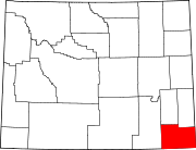
Towns Albin | Burns | Pine Bluffs
CDPs Fox Farm-College | Ranchettes | South Greeley | Warren AFB
Unincorporated
communitiesCarpenter | Granite | Hillsdale | Horse Creek | Meriden
 State of Wyoming
Topics - Governors
- Delegations
- Geography
- Government
- History
- People
- Visitor Attractions
- State Symbols
- Radio Stations
Society - Crime
- Demographics
- Economy
- Education
- Politics
Regions Cities Counties Categories:- Wyoming counties
- Laramie County, Wyoming
- 1867 establishments


Wikimedia Foundation. 2010.