- Meriden, Wyoming
-
Meriden, Wyoming — Unincorporated crossroads — Location within the state of Wyoming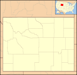
 Meriden, Wyoming
Coordinates: 41°32′37″N 104°19′09″W / 41.54361°N 104.31917°WCoordinates: 41°32′37″N 104°19′09″W / 41.54361°N 104.31917°W Country United States State Wyoming County Laramie Elevation 4,957 ft (1,511 m) Time zone Mountain (MST) (UTC-7) - Summer (DST) MDT (UTC-6) ZIP codes FIPS code GNIS feature ID Meriden is an unincorporated crossroads in Laramie County, Wyoming, United States. It is part of the Cheyenne, Wyoming Metropolitan Statistical Area and is located about 45 miles northeast of Cheyenne.
The community was named after Meriden, Connecticut.
Public education in the community of Meriden is provided by Laramie County School District #2.
Geography
Meriden is located at an elevation of 4,957 feet, at the junction of U.S. Highway 85 (Torrington Rd) and Laramie County Road 238 just south of the Goshen County line, and about 10 miles from the Nebraska state line. Horse Creek runs through Meriden.
Municipalities and communities of Laramie County, Wyoming County seat: Cheyenne City 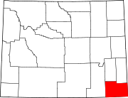
Towns Albin | Burns | Pine Bluffs
CDPs Fox Farm-College | Ranchettes | South Greeley | Warren AFB
Unincorporated
communitiesCarpenter | Granite | Hillsdale | Horse Creek | Meriden
Categories:- Unincorporated communities in Wyoming
- Populated places in Laramie County, Wyoming
- Wyoming geography stubs


Wikimedia Foundation. 2010.