- Allenspark, Colorado
Infobox Settlement
name = Allenspark, Colorado
other_name =
native_name =
nickname =
settlement_type =census-designated place
motto =
imagesize =
image_caption =
flag_size =
image_
seal_size =
image_shield =
shield_size =
image_blank_emblem =
blank_emblem_type =
blank_emblem_size =
imagesize =
image_caption =
flag_size =
image_
seal_size =
image_shield =
shield_size =
image_blank_emblem =
blank_emblem_type =
blank_emblem_size =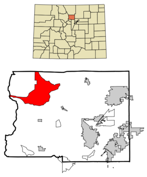
mapsize = 250px
map_caption = Location in Boulder County and theState of Colorado
mapsize1 =
map_caption1 =
image_dot_
dot_mapsize =
dot_map_caption =
dot_x =
dot_y =
pushpin_
pushpin_label_position =
pushpin_map_caption =
pushpin_mapsize =
subdivision_type = Country
subdivision_name = USA
subdivision_type1 = State
subdivision_name1 = flag|Colorado|name=State of Colorado
subdivision_type2 = County
subdivision_name2 = Boulder CountyGR|3
subdivision_type3 =
subdivision_name3 =
subdivision_type4 =
subdivision_name4 =
government_footnotes =
government_type =unincorporated town
leader_title =
leader_name =
leader_title1 =
leader_name1 =
leader_title2 =
leader_name2 =
leader_title3 =
leader_name3 =
leader_title4 =
leader_name4 =
established_title =
established_date =
established_title2 =
established_date2 =
established_title3 =
established_date3 =
area_magnitude =
unit_pref = Imperial
area_footnotes =
area_total_km2 = 110.7
area_land_km2 = 110.7
area_water_km2 = 0
area_total_sq_mi = 42.8
area_land_sq_mi = 42.8
area_water_sq_mi = 0
area_water_percent =
area_urban_km2 =
area_urban_sq_mi =
area_metro_km2 =
area_metro_sq_mi =
area_blank1_title =
area_blank1_km2 =
area_blank1_sq_mi =
population_as_of = 2000
population_footnotes =
population_note =
population_total = 496
population_density_km2 = 4.5
population_density_sq_mi = 11.6
population_metro =
population_density_metro_km2 =
population_density_metro_sq_mi =
population_urban =
population_density_urban_km2 =
population_density_urban_sq_mi =
population_blank1_title =
population_blank1 =
population_density_blank1_km2 =
population_density_blank1_sq_mi =
timezone = MST
utc_offset = -7
timezone_DST = MDT
utc_offset_DST = -6
latd = 40 |latm = 12 |lats = 9 |latNS = N
longd = 105 |longm = 30 |longs = 48 |longEW = W
elevation_footnotes = GR|3
elevation_m = 2592
elevation_ft = 8504
postal_code_type =ZIP code
postal_code = 80510cite web | date = December 14, 2006 | url = http://zip4.usps.com/zip4/citytown.jsp | title = ZIP Code Lookup| format =JavaScript /HTML | publisher = United States Postal Service | accessdate = December 14 | accessyear = 2006]
area_code = 303
blank_name =Highway s
blank_info =
blank1_name = GNIS feature ID
blank1_info = [http://geonames.usgs.gov/pls/gnispublic/f?p=gnispq:3:::NO::P3_FID:0178219 0178219]
website =
footnotes =Allenspark is a
census-designated place (CDP) in Boulder County,Colorado ,United States . The population was 496 at the 2000 census.GR|2 The Allenspark Post Office has theZIP Code 80510.Geography
Allenspark is located at coor dms|40|12|9|N|105|30|48|W|city (40.202416, -105.513341)GR|1.
According to the
United States Census Bureau , the CDP has a total area of 42.8square mile s (110.7km² ), all of it land.Demographics
As of the
census GR|2 of 2000, there were 496 people, 249 households, and 140 families residing in the CDP. Thepopulation density was 11.6 people per square mile (4.5/km²). There were 786 housing units at an average density of 18.4/sq mi (7.1/km²). The racial makeup of the CDP was 95.97% White, 0.20% African American, 0.60% Native American, 1.01% Asian, 0.60% from other races, and 1.61% from two or more races. Hispanic or Latino of any race were 1.61% of the population.There were 249 households out of which 13.3% had children under the age of 18 living with them, 53.4% were married couples living together, 1.2% had a female householder with no husband present, and 43.4% were non-families. 35.3% of all households were made up of individuals and 8.8% had someone living alone who was 65 years of age or older. The average household size was 1.92 and the average family size was 2.45.
In the CDP the population was spread out with 11.5% under the age of 18, 4.0% from 18 to 24, 27.4% from 25 to 44, 42.5% from 45 to 64, and 14.5% who were 65 years of age or older. The median age was 49 years. For every 100 females there were 105.8 males. For every 100 females age 18 and over, there were 105.1 males.
The median income for a household in the CDP was $42,596, and the median income for a family was $65,536. Males had a median income of $27,857 versus $35,208 for females. The
per capita income for the CDP was $28,333. None of the families and 10.0% of the population were living below thepoverty line , including no under eighteens and 10.7% of those over 64.ee also
*
Colorado cities and towns
*Colorado counties
*Colorado metropolitan areas
**Boulder Metropolitan Statistical Area
**Denver-Aurora-Boulder Combined Statistical Area
**North Central Colorado Urban Area
**Front Range Urban Corridor
*United States Forest Service
**Roosevelt National Forest
*United States National Park Service
**Rocky Mountain National Park References
External links
Wikimedia Foundation. 2010.