- Coal Creek, Boulder County, Colorado
-
For the town near Cañon City, see Coal Creek, Fremont County, Colorado.
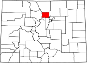
Coal Creek, Colorado — CDP — Location in Boulder County and the State of Colorado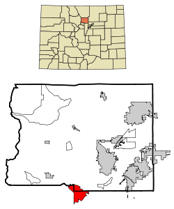
Coordinates: 39°54′32″N 105°23′12″W / 39.90889°N 105.38667°WCoordinates: 39°54′32″N 105°23′12″W / 39.90889°N 105.38667°W Country  United States
State  State of Colorado
Counties Boulder, Gilpin, & Jefferson Government – Type unincorporated community Area – Total 9.4 sq mi (24.4 km2) – Land 9.4 sq mi (24.4 km2) – Water 0 sq mi (0 km2) Elevation[1] 8,599 ft (2,621 m) Population (2010) – Total 2,400 – Density 247.1/sq mi (95.2/km2) Time zone MST (UTC-7) – Summer (DST) MDT (UTC-6) Coal Creek, locally known as Coal Creek Canyon, is a census-designated place (CDP) in Boulder, Gilpin, and Jefferson counties in the U.S. state of Colorado. The population was 2,400 at the 2010 census.[2]
Contents
Geography
Coal Creek is located at 39°54′32″N 105°23′12″W / 39.90889°N 105.38667°W (39.908835, -105.386801)[3].
According to the United States Census Bureau, the CDP has a total area of 9.4 square miles (24 km2), of which, 9.4 square miles (24 km2) of it is land and 0.11% is water.
Demographics
As of the census[4] of 2000, there were 2,323 people, 985 households, and 650 families residing in the CDP. The population density was 246.4 people per square mile (95.1/km²). There were 1,168 housing units at an average density of 123.9 per square mile (47.8/km²). The racial makeup of the CDP was 95.52% White, 0.17% African American, 0.47% Native American, 0.99% Asian, 1.16% from other races, and 1.68% from two or more races. Hispanic or Latino of any race were 3.79% of the population.
There were 985 households out of which 28.0% had children under the age of 18 living with them, 58.5% were married couples living together, 4.6% had a female householder with no husband present, and 34.0% were non-families. 21.8% of all households were made up of individuals and 2.2% had someone living alone who was 65 years of age or older. The average household size was 2.36 and the average family size was 2.77.
In the CDP the population was spread out with 20.9% under the age of 18, 4.3% from 18 to 24, 38.5% from 25 to 44, 31.4% from 45 to 64, and 4.9% who were 65 years of age or older. The median age was 40 years. For every 100 females there were 116.1 males. For every 100 females age 18 and over, there were 116.6 males.
The median income for a household in the CDP was $73,750, and the median income for a family was $79,129. Males had a median income of $48,295 versus $34,856 for females. The per capita income for the CDP was $34,911. About 2.7% of families and 3.6% of the population were below the poverty line, including 3.3% of those under age 18 and 5.5% of those age 65 or over.
See also
- Colorado cities and towns
- Colorado counties
- Colorado metropolitan areas
- Boulder Metropolitan Statistical Area
- Denver-Aurora Metropolitan Statistical Area
- Denver-Aurora-Boulder Combined Statistical Area
- North Central Colorado Urban Area
- Front Range Urban Corridor
References
- ^ "US Board on Geographic Names". United States Geological Survey. 2007-10-25. http://geonames.usgs.gov. Retrieved 2008-01-31.
- ^ Colorado Trend Report 2: State and Complete Places (Sub-state 2010 Census Data). Missouri Census Data Center. Accessed 2011-02-25.
- ^ "US Gazetteer files: 2010, 2000, and 1990". United States Census Bureau. 2011-02-12. http://www.census.gov/geo/www/gazetteer/gazette.html. Retrieved 2011-04-23.
- ^ "American FactFinder". United States Census Bureau. http://factfinder.census.gov. Retrieved 2008-01-31.
External links
Municipalities and communities of Boulder County, Colorado Cities Boulder | Lafayette | Longmont‡ | Louisville
Towns CDPs Allenspark | Altona | Bark Ranch | Bonanza Mountain Estates | Coal Creek‡ | Crisman | Eldora | Eldorado Springs | Glendale | Gold Hill | Gunbarrel | Hidden Lake | Lazy Acres | Leyner | Mountain Meadows | Niwot | Paragon Estates | Pine Brook Hill | Sugarloaf | St. Ann Highlands | Seven Hills | Sunshine | Tall Timber | Valmont
Unincorporated
communitiesCaribou | Hygiene | Pinecliffe
Footnotes ‡This populated place also has portions in an adjacent county or counties
Municipalities and communities of Gilpin County, Colorado Cities 
CDPs Coal Creek‡ | Rollinsville
Unincorporated
communitiesFootnotes ‡This populated place also has portions in an adjacent county or counties
Municipalities and communities of Jefferson County, Colorado Cities Arvada‡ | Edgewater | Golden | Lakewood | Littleton‡ | Westminster‡ | Wheat Ridge
Towns Bow Mar‡ | Lakeside | Morrison | Mountain View | Superior‡
CDPs Applewood | Aspen Park | Coal Creek‡ | Columbine‡ | Dakota Ridge | East Pleasant View | Evergreen | Fairmount | Genesee | Idledale | Indian Hills | Ken Caryl | Kittredge | West Pleasant View
Unincorporated
communitiesBuffalo Creek | Conifer | Foxton | Pine | Pine Junction
Ghost town Arapahoe
Footnotes ‡This populated place also has portions in an adjacent county or counties
Categories:- Populated places in Boulder County, Colorado
- Populated places in Jefferson County, Colorado
- Populated places in Gilpin County, Colorado
- Census-designated places in Colorado
- Denver metropolitan area


Wikimedia Foundation. 2010.