- Gold Hill, Colorado
Infobox Settlement
official_name = Gold Hill, Colorado
other_name =
native_name =
nickname =
settlement_type = CDP
motto =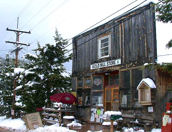
imagesize =
image_caption =
flag_size =
image_
seal_size =
image_shield =
shield_size =
image_blank_emblem =
blank_emblem_type =
blank_emblem_size =
flag_size =
image_
seal_size =
image_shield =
shield_size =
image_blank_emblem =
blank_emblem_type =
blank_emblem_size =
mapsize = 250px
map_caption = Location in Boulder County and the state ofColorado
mapsize1 =
map_caption1 =
image_dot_
dot_mapsize =
dot_map_caption =
dot_x =
dot_y =
pushpin_
pushpin_label_position =
pushpin_map_caption =
pushpin_mapsize =
subdivision_type = Country
subdivision_name = USA
subdivision_type1 = State
subdivision_name1 = flag|Colorado
subdivision_type2 = County
subdivision_name2 = Boulder
subdivision_type3 =
subdivision_name3 =
subdivision_type4 =
subdivision_name4 =
government_footnotes =
government_type =
leader_title =
leader_name =
leader_title1 =
leader_name1 =
leader_title2 =
leader_name2 =
leader_title3 =
leader_name3 =
leader_title4 =
leader_name4 =
established_title =
established_date =
established_title2 =
established_date2 =
established_title3 =
established_date3 =
area_magnitude =
unit_pref = Imperial
area_footnotes =
area_total_km2 = 5.2
area_land_km2 = 5.2
area_water_km2 = 0
area_total_sq_mi = 2
area_land_sq_mi = 2
area_water_sq_mi = 0
area_water_percent =
area_urban_km2 =
area_urban_sq_mi =
area_metro_km2 =
area_metro_sq_mi =
area_blank1_title =
area_blank1_km2 =
area_blank1_sq_mi =
population_as_of = 2000
population_footnotes =
population_note =
population_total = 210
population_density_km2 = 40.4
population_density_sq_mi = 105
population_metro =
population_density_metro_km2 =
population_density_metro_sq_mi =
population_urban =
population_density_urban_km2 =
population_density_urban_sq_mi =
population_blank1_title =
population_blank1 =
population_density_blank1_km2 =
population_density_blank1_sq_mi =
timezone = MST
utc_offset = -7
timezone_DST = MDT
utc_offset_DST = -6
latd = 40 |latm = 3 |lats = 50 |latNS = N
longd = 105 |longm = 24 |longs = 43 |longEW = W
elevation_footnotes =
elevation_m = 2530
elevation_ft = 8300
postal_code_type =ZIP code
postal_code = 80302 (Boulder)
area_code =
blank_name = FIPS code
blank_info = 08-30945
blank1_name = GNIS feature ID
blank1_info = 0178502
website =
footnotes =Gold Hill is a
census-designated place (CDP) in Boulder County,Colorado ,United States . The population was 210 at the 2000 census. This settlement is located to the northwest of Boulder, perched on a mountainside aboveLeft Hand Canyon at an elevation of 8,300 feet. Originally a mining camp, it was the site of the first major discovery of gold during the1859 Colorado Gold Rush and remained an important mining camp throughout the late 19th century, with a population approaching 1500 at its height, before falling into decline. It has been revived somewhat in recent years as a quiet isolated haven, with no paved streets, but easily accessed by dirt roads. The town contains numerous historic wooden structures, some restored in recent years, as well decaying ruins from its mining heyday. It has a small museum and two-room schoolhouse, the Gold Hill School, which since 1873 has been the oldest continuously operating public school in Colorado. Other businesses include a General Store and a restored inn listed on theNational Register of Historic Places . The town is laid out on a small grid of gravel streets.Gold Hill is accessible from nearby
Left Hand Canyon Road via Lick Skillet Road, the steepestcounty road in theUnited States . Easier approaches to Gold Hill include Sunshine Canyon Road from 4th and Mapleton in Boulder, Gold Run Road from Salina (on Four Mile Canyon Road), and Gold Hill Road from thePeak-to-Peak Highway (State Highway 72) south of Ward. All of these roads are susceptible to heavy snows during the winter which at times render Gold Hill inaccessible to vehicles not equipped with chains or four wheel drive.Gold Hill is sometimes labeled a
ghost town , which is an inaccurate designation. Gold Hill is part of unincorporatedBoulder County , and while it does not have amunicipal government , it does have an activetown meeting with elected officials.History
The town is located above Gold Run, the first lode discovery of gold in Colorado (at that time the area was part of the
Nebraska Territory ) onJanuary 15 ,1859 . The discovery occurred nearly simultaneous with prospecting inGregory Gulch and Clear Creek, but these latter discoveries were not exploited until later that Spring. OnMarch 7 , 1859, the Gold Run discovery became the first mining district in region (named either the Mountain District No. 1, Mining District No. 1 of the Nebraska Territory, or the Nebraska Gold Hill Mining District, according to various historical sources). Word quickly spread among miners in the region, prompting a flood of new arrivals and the establishment of Gold Hill as the first permanent mining camp in present-day Colorado. By autumn, aquartz stamp mill was erected at the base of the hill, the first such piece of equipment in the region, one that had been transported byox cart westward over theGreat Plains . The first productive vein was the Scott, followed quickly the Horsfal, Alamakee, and Cold Spring. Nearby placers were also worked for the gold in stream beds.By 1861, the year of the organization of the
Colorado Territory , the surface deposits of gold in the vicinity of the town were largely played out, resulting in a temporary exodus of prospectors and a population decrease. The town was somewhat revived later that year by the construction of the Hillsmelter at nearby Black Hawk, allowing the treatment of lower-grade ores.The discovery of
tellurium in the area in 1872 prompted a second boom, bringing the population to nearly 1000 once again. At its height, the town had a newspaper and number of hotels, including the Mines Hotel, built in 1872 and recently restored as summer tourist destination. The Mines was immortalized in verse bypoet Eugene Field , who stayed at the hotel while working as a newspaper man in Denver. The town population dwindled in the early 20th century as the mining tapered off. The town has experienced two major fires in its history, but it nevertheless retains many of its historic wooden structures.Geography
Gold Hill is located at coor dms|40|3|50|N|105|24|43|W|city (40.063785, -105.411911)GR|1.
According to the
United States Census Bureau , the CDP has a total area of 2.0square mile s (5.2km² ), all of it land.Demographics
As of the
census GR|2 of 2000, there were 210 people, 90 households, and 47 families residing in the CDP. Thepopulation density was 104.7 people per square mile (40.3/km²). There were 114 housing units at an average density of 56.8/sq mi (21.9/km²). The racial makeup of the CDP was 89.05% White, 0.48% African American, 3.33% Native American, 1.90% Asian, 4.29% from other races, and 0.95% from two or more races. Hispanic or Latino of any race were 7.62% of the population.There were 90 households out of which 33.3% had children under the age of 18 living with them, 46.7% were married couples living together, 2.2% had a female householder with no husband present, and 46.7% were non-families. 35.6% of all households were made up of individuals and 1.1% had someone living alone who was 65 years of age or older. The average household size was 2.33 and the average family size was 3.00.
In the CDP the population was spread out with 22.9% under the age of 18, 4.8% from 18 to 24, 37.1% from 25 to 44, 32.4% from 45 to 64, and 2.9% who were 65 years of age or older. The median age was 40 years. For every 100 females there were 114.3 males. For every 100 females age 18 and over, there were 116.0 males.
The median income for a household in the CDP was $48,750, and the median income for a family was $76,850. Males had a median income of $48,929 versus $12,105 for females. The
per capita income for the CDP was $24,675. None of the population or families were below thepoverty line .External links
References
*"Jeep Trails to Colorado Ghost Towns "
Wikimedia Foundation. 2010.