- National Register of Historic Places listings in Polk County, Tennessee
-
 Location of Polk County in Tennessee
This is a list of the National Register of Historic Places listings in Polk County, Tennessee.
This is intended to be a complete list of the properties and districts on the National Register of Historic Places in Polk County, Tennessee, United States. Latitude and longitude coordinates are provided for many National Register properties and districts; these locations may be seen together in a Google map.[1]
There are 17 properties and districts listed on the National Register in the county.
Contents: Counties in Tennessee Anderson – Bedford – Benton – Bledsoe – Blount – Bradley – Campbell – Cannon – Carroll – Carter – Cheatham – Chester – Claiborne – Clay – Cocke – Coffee – Crockett – Cumberland – Davidson – Decatur – DeKalb – Dickson – Dyer – Fayette – Fentress – Franklin – Gibson – Giles – Grainger – Greene – Grundy – Hamblen – Hamilton – Hancock – Hardeman – Hardin – Hawkins – Haywood – Henderson – Henry – Hickman – Houston – Humphreys – Jackson – Jefferson – Johnson – Knox – Lake – Lauderdale – Lawrence – Lewis – Lincoln – Loudon – Macon – Madison – Marion – Marshall – Maury – McMinn – McNairy – Meigs – Monroe – Montgomery – Moore – Morgan – Obion – Overton – Perry – Pickett – Polk – Putnam – Rhea – Roane – Robertson – Rutherford – Scott – Sequatchie – Sevier – Shelby – Smith – Stewart – Sullivan – Sumner – Tipton – Trousdale – Unicoi – Union – Van Buren – Warren – Washington – Wayne – Weakley – White – Williamson – Wilson -
- This National Park Service list is complete through NPS recent listings posted November 10, 2011.[2]
Current listings
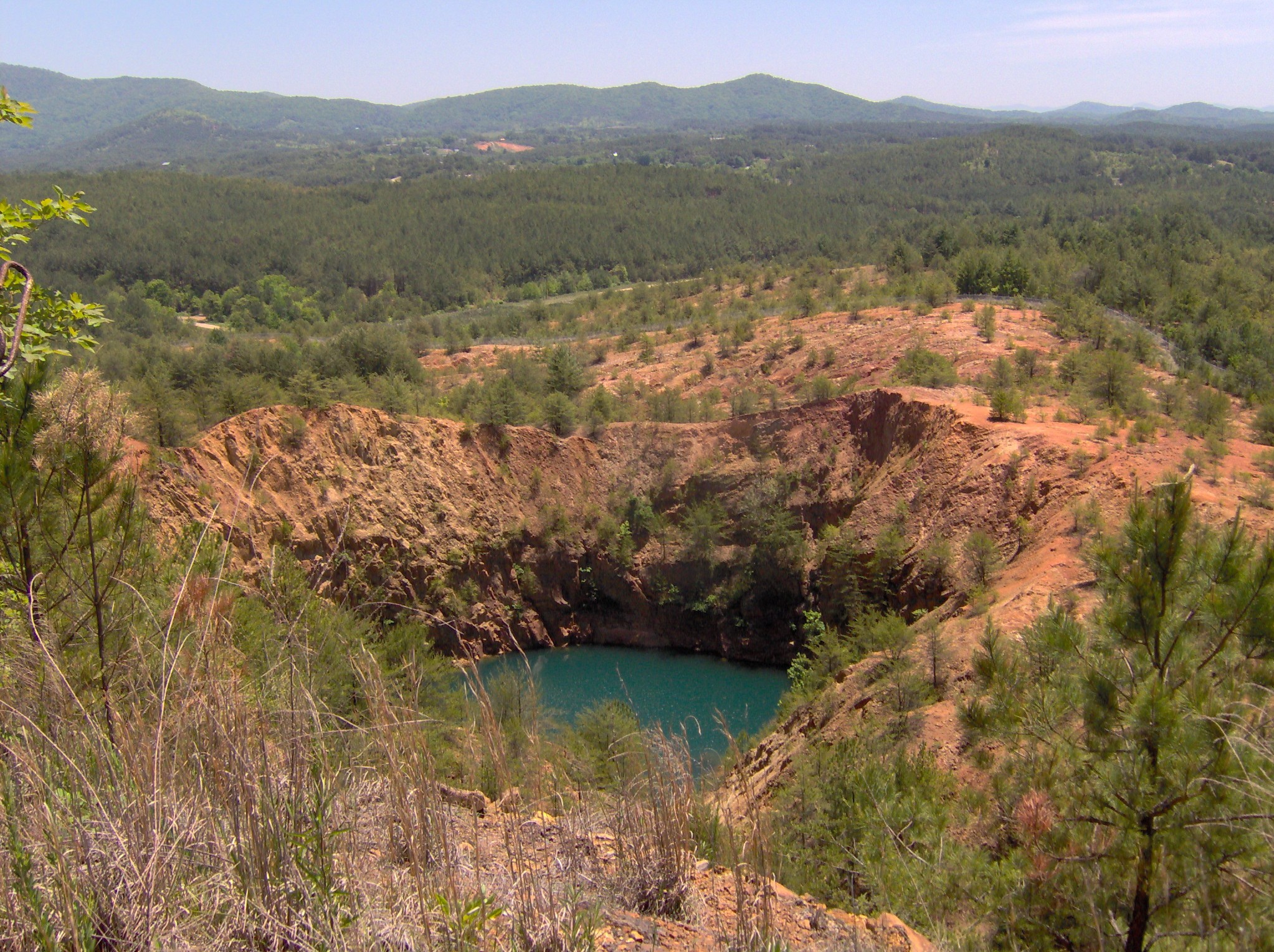
[3] Landmark name [4] Image Date listed Location City or town Summary 1 Burra Burra Mine Historic District 
March 17, 1983 State Route 68 and Burra St.
35°02′07″N 84°22′46″W / 35.035278°N 84.379444°WDucktown 2 Buzzard's Roost Historic District May 15, 1992 301-400 College, 420-430 Ell and 129-186 Main Sts., 400-415 School House Rd., and 211 and 215 State Route 68
35°01′59″N 84°23′04″W / 35.033056°N 84.384444°WDucktown 3 Center & Abernathy Store Building September 2, 1992 23-33 Ocoee St.
34°59′18″N 84°22′16″W / 34.988333°N 84.371111°WCopperhill 4 Central Headframe September 2, 1992 State Route 68 south of its junction with U.S. Routes 64/74
35°01′16″N 84°22′55″W / 35.021111°N 84.381944°WDucktown 5 Copeland House April 5, 1984 Cookson Creek Rd.
35°05′04″N 84°40′10″W / 35.084444°N 84.669444°WParksville 6 Copperhill Historic District May 15, 1992 Roughly bounded by Hill, Prospect, Main, and Riverview Sts.
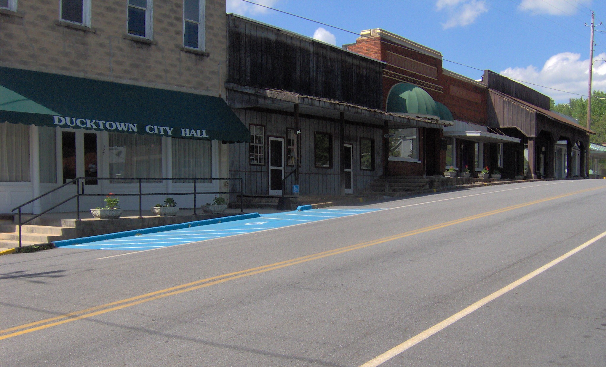
34°59′22″N 84°22′10″W / 34.989444°N 84.369444°WCopperhill 7 Ducktown Historic District 
May 15, 1992 Roughly bounded by State Route 68 and an alley 2 blocks northwest of Main St.
35°02′13″N 84°22′55″W / 35.036944°N 84.381944°WDucktown 8 Isabella Managers' Row May 15, 1992 Ducktown-Isabella Rd. north of U.S. Route 64
35°01′28″N 84°21′37″W / 35.024444°N 84.360278°WIsabella 9 Kimsey Junior College September 2, 1992 244 State Route 68
35°04′12″N 88°19′49″W / 35.07°N 88.330278°WDucktown 10 Knoxville Southern Railroad Historic District March 21, 2007 Former Knoxville Southern railroad line from near Reliance to near Farner Reliance 11 Newtown Historic District May 15, 1992 510-521 1st, 538-730 2nd, and 580-730 3rd Sts.
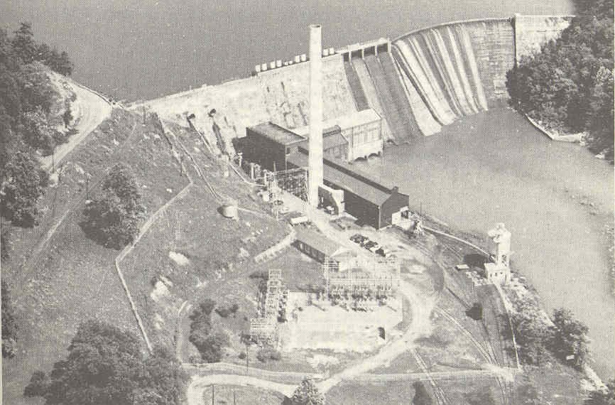
34°59′36″N 84°22′15″W / 34.993333°N 84.370833°WCopperhill 12 Ocoee Hydroelectric Plant No. 2 
October 31, 1979 U.S. Route 64
35°05′10″N 84°30′48″W / 35.086111°N 84.513333°WOcoee 13 Ocoee No. 1 Hydroelectric Station 
July 5, 1990 Junction of U.S. Route 64 and the Ocoee River
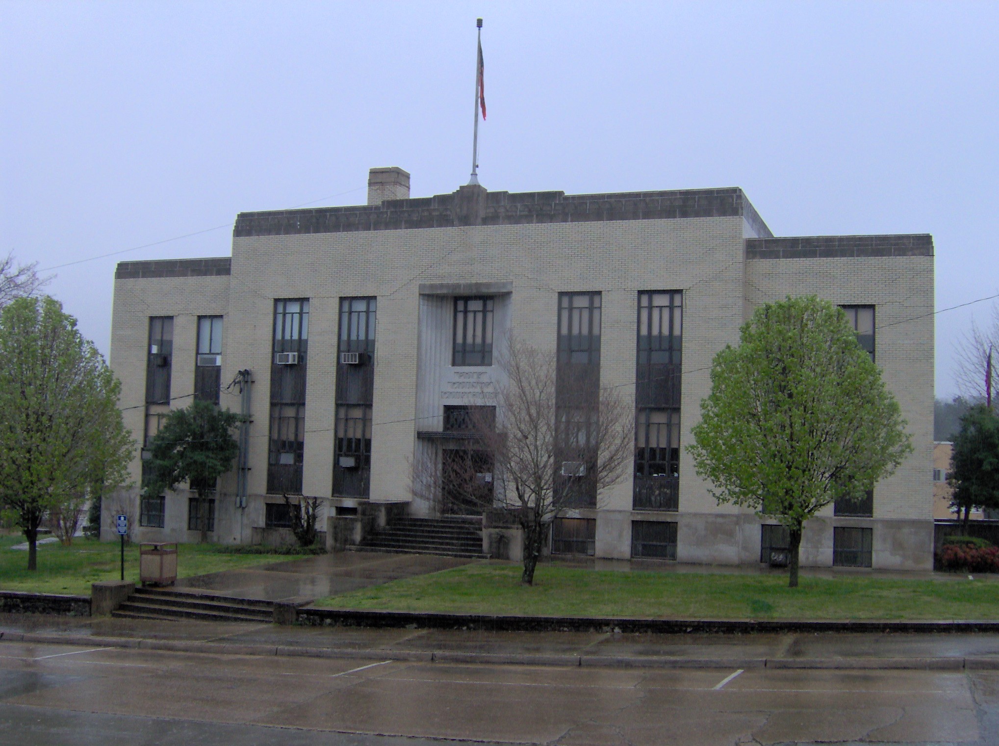
35°05′40″N 84°38′52″W / 35.094444°N 84.647778°WParksville 14 Polk County Courthouse 
June 24, 1993 Bounded by U.S. Route 411 and Ward, Commerce, and Main Sts.
35°10′24″N 84°39′12″W / 35.173333°N 84.653333°WBenton 15 Reliance Historic District March 13, 1986 Roughly bounded by New Reliance and Power House Rds., State Route 30, and the Hiwassee River
35°11′23″N 84°30′08″W / 35.189722°N 84.502222°WReliance 16 Nancy Ward Tomb April 11, 1973 South of Benton on U.S. Route 411
35°09′51″N 84°40′50″W / 35.164167°N 84.680556°WBenton 17 William Wiggins House 
December 2, 1993 Northeastern corner of the junction of Main and Ward Sts.
35°10′26″N 84°39′12″W / 35.173889°N 84.653333°WBenton See also
- List of National Historic Landmarks in Tennessee
- National Register of Historic Places listings in Tennessee
References
- ^ The latitude and longitude information provided in this table was derived originally from the National Register Information System, which has been found to be fairly accurate for about 99% of listings. For about 1% of NRIS original coordinates, experience has shown that one or both coordinates are typos or otherwise extremely far off; some corrections may have been made. A more subtle problem causes many locations to be off by up to 150 yards, depending on location in the country: most NRIS coordinates were derived from tracing out latitude and longitudes off of USGS topographical quadrant maps created under the North American Datum of 1927, which differs from the current, highly accurate WGS84 GPS system used by Google maps. Chicago is about right, but NRIS longitudes in Washington are higher by about 4.5 seconds, and are lower by about 2.0 seconds in Maine. Latitudes differ by about 1.0 second in Florida. Some locations in this table may have been corrected to current GPS standards.
- ^ "National Register of Historic Places: Weekly List Actions". National Park Service, United States Department of the Interior. Retrieved on November 10, 2011.
- ^ Numbers represent an ordering by significant words. Various colorings, defined here, differentiate National Historic Landmark sites and National Register of Historic Places Districts from other NRHP buildings, structures, sites or objects.
- ^ "National Register Information System". National Register of Historic Places. National Park Service. . http://nrhp.focus.nps.gov/natreg/docs/All_Data.html.
U.S. National Register of Historic Places Topics Lists by states Alabama • Alaska • Arizona • Arkansas • California • Colorado • Connecticut • Delaware • Florida • Georgia • Hawaii • Idaho • Illinois • Indiana • Iowa • Kansas • Kentucky • Louisiana • Maine • Maryland • Massachusetts • Michigan • Minnesota • Mississippi • Missouri • Montana • Nebraska • Nevada • New Hampshire • New Jersey • New Mexico • New York • North Carolina • North Dakota • Ohio • Oklahoma • Oregon • Pennsylvania • Rhode Island • South Carolina • South Dakota • Tennessee • Texas • Utah • Vermont • Virginia • Washington • West Virginia • Wisconsin • WyomingLists by territories Lists by associated states Other Municipalities and communities of Polk County, Tennessee Cities 
Town Unincorporated
communitiesDelano | Farner | Ocoee | Old Fort | Reliance | Turtletown
Categories:- National Register of Historic Places in Tennessee by county
- Polk County, Tennessee
- Buildings and structures in Polk County, Tennessee
-

Wikimedia Foundation. 2010.