- National Register of Historic Places listings in Bedford County, Tennessee
-
 Location of Bedford County in Tennessee
This is a list of the National Register of Historic Places listings in Bedford County, Tennessee.
This is intended to be a complete list of the properties and districts on the National Register of Historic Places in Bedford County, Tennessee, United States. Latitude and longitude coordinates are provided for many National Register properties and districts; these locations may be seen together in a Google map.[1]
There are 30 properties and districts listed on the National Register in the county. One other property was once listed, but has since been removed.
Contents: Counties in Tennessee Anderson – Bedford – Benton – Bledsoe – Blount – Bradley – Campbell – Cannon – Carroll – Carter – Cheatham – Chester – Claiborne – Clay – Cocke – Coffee – Crockett – Cumberland – Davidson – Decatur – DeKalb – Dickson – Dyer – Fayette – Fentress – Franklin – Gibson – Giles – Grainger – Greene – Grundy – Hamblen – Hamilton – Hancock – Hardeman – Hardin – Hawkins – Haywood – Henderson – Henry – Hickman – Houston – Humphreys – Jackson – Jefferson – Johnson – Knox – Lake – Lauderdale – Lawrence – Lewis – Lincoln – Loudon – Macon – Madison – Marion – Marshall – Maury – McMinn – McNairy – Meigs – Monroe – Montgomery – Moore – Morgan – Obion – Overton – Perry – Pickett – Polk – Putnam – Rhea – Roane – Robertson – Rutherford – Scott – Sequatchie – Sevier – Shelby – Smith – Stewart – Sullivan – Sumner – Tipton – Trousdale – Unicoi – Union – Van Buren – Warren – Washington – Wayne – Weakley – White – Williamson – Wilson -
- This National Park Service list is complete through NPS recent listings posted November 10, 2011.[2]
Current listings
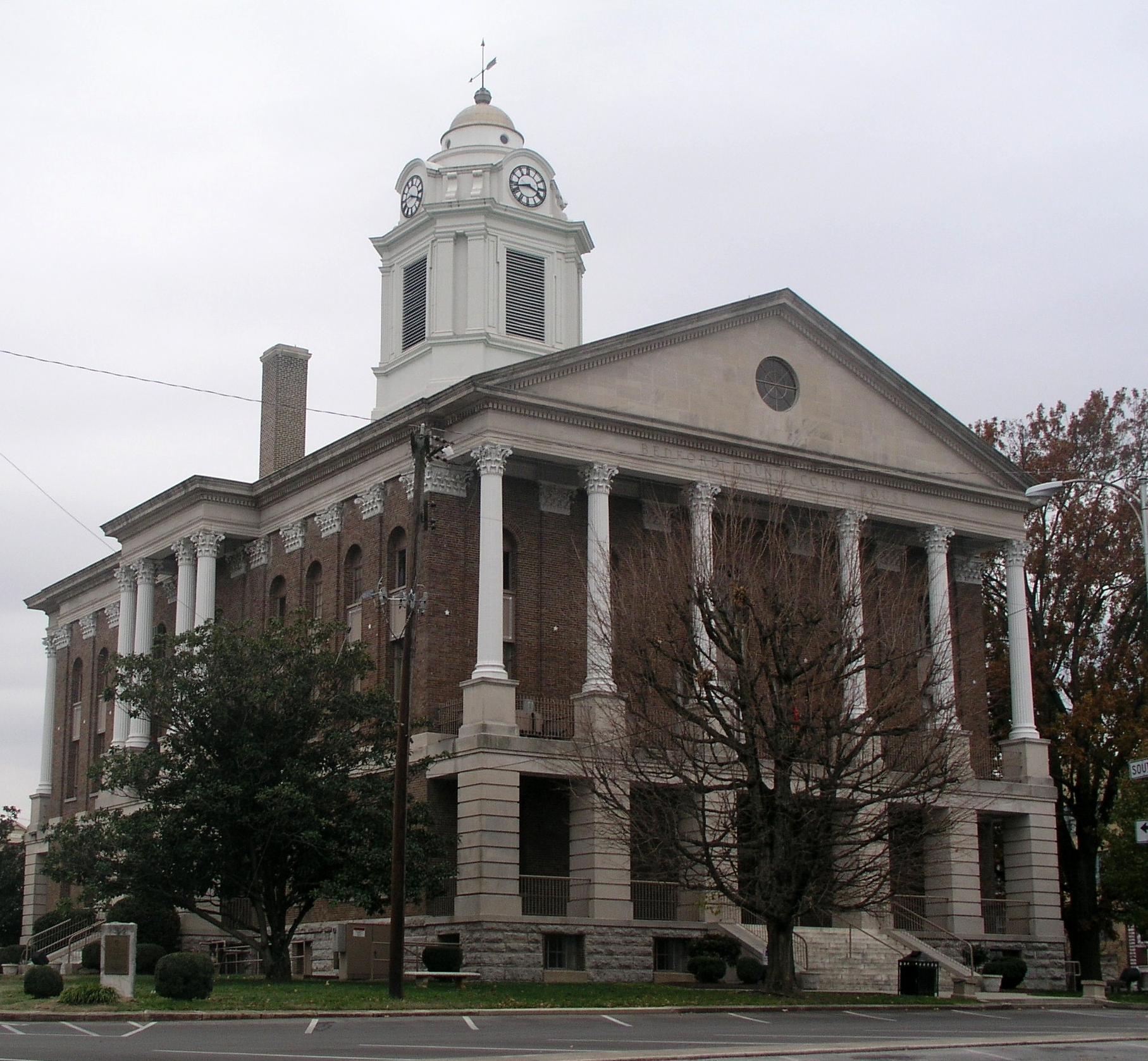
[3] Landmark name [4] Image Date listed Location City or town Summary 1 Bedford County Jail April 1, 1975 N. Spring and Jackson Sts.
35°29′04″N 86°27′38″W / 35.484444°N 86.460556°WShelbyville 2 Bell Buckle Historic District January 20, 1976 Irregular pattern bounded roughly by Webb Rd., Abernathy, Maple, Cumberland, and Church Sts.
35°35′N 86°21′W / 35.59°N 86.35°WBell Buckle 3 Brame-Reed House January 23, 1998 1550 State Route 64, W.
35°27′21″N 86°32′39″W / 35.455833°N 86.544167°WShelbyville 4 Henry A. Clark House August 30, 1985 Fairfield Rd.
35°32′32″N 86°19′44″W / 35.542222°N 86.328889°WWartrace 5 Gov. Prentice Cooper House June 5, 1975 413 E. Lane St.
35°29′06″N 86°27′12″W / 35.485°N 86.453333°WShelbyville 6 Spencer Eakin Farm June 24, 1993 201 Nashville Dirt Rd.
35°30′32″N 86°28′16″W / 35.508889°N 86.471111°WShelbyville 7 East Shelbyville Historic District April 23, 1990 Bounded roughly by N. Brittian, former Louisville & Nashville railroad tracks, and Lane, Evans, Sandusky, and Madison Sts.
35°29′10″N 86°27′16″W / 35.486111°N 86.454444°WShelbyville 8 Winston Evans House November 27, 1989 306 E. Franklin St.
35°29′08″N 86°27′23″W / 35.485556°N 86.456389°WShelbyville 9 Farrar Homeplace November 7, 1990 170 Ike Farrar Rd.
35°21′37″N 86°23′24″W / 35.360278°N 86.39°WShelbyville 10 First Presbyterian Church July 17, 1980 600 N. Brittain St.
35°29′10″N 86°27′29″W / 35.486111°N 86.458056°WShelbyville 11 Fly Manufacturing Company Building March 7, 1996 204 S. Main St.
35°28′53″N 86°27′42″W / 35.481389°N 86.461667°WShelbyville 12 Frierson-Coble House April 12, 1982 404 N. Jefferson St.
35°29′06″N 86°27′27″W / 35.485°N 86.4575°WShelbyville 13 James Gilliland House May 12, 1975 803 Lipscomb St.
35°29′38″N 86°27′38″W / 35.493889°N 86.460556°WShelbyville 14 Grassland Farm March 4, 1975 8 miles southwest of Shelbyville on Snell Rd.
35°24′16″N 86°30′43″W / 35.404444°N 86.511944°WShelbyville 15 Heidt Tavern-Singleton House June 24, 1991 115 Dr. Jackson Rd.
35°33′58″N 86°16′55″W / 35.566111°N 86.281944°WWartrace 16 Jenkins Lutheran Chapel and Cemetery October 17, 1997 364 Shofner Bridge Rd.
35°27′47″N 86°22′49″W / 35.463056°N 86.380278°WShelbyville 17 Absalom Lowe Landis House June 25, 1987 Thompson's Creek Rd.
35°26′51″N 86°19′25″W / 35.4475°N 86.323611°WNormandy 18 Maple Dean Farm March 30, 1995 400 New Herman Rd.
35°22′30″N 86°25′48″W / 35.375°N 86.43°WShelbyville 19 Martin House April 14, 1972 7 miles northeast of Wartrace off State Route 64
35°35′52″N 86°15′40″W / 35.597778°N 86.261111°WWartrace 20 Normandy Historic District November 7, 1985 Roughly bounded by Maple and Poplar Sts., Tullahoma Rd., College St., and Old Manchester Rd.
35°27′06″N 86°15′34″W / 35.451667°N 86.259444°WNormandy 21 Palmetto Farm March 28, 1985 State Route 64
35°29′28″N 86°39′49″W / 35.491111°N 86.663611°WPalmetto 22 River Side Farmhouse December 1, 1997 497 Shofner Rd.
35°26′58″N 86°22′53″W / 35.449444°N 86.381389°WShelbyville 23 Shelbyville Courthouse Square Historic District 
October 27, 1982 Public Square (Main, Spring, Depot, and Holland Sts.)
35°28′57″N 86°27′37″W / 35.4825°N 86.460278°WShelbyville 24 Shelbyville Hydroelectric Station February 9, 1990 State Route 231 at the Duck River
35°29′08″N 86°28′01″W / 35.485556°N 86.466944°WShelbyville 25 Shelbyville Railroad Station March 24, 1988 Depot St.
35°28′55″N 86°27′24″W / 35.481944°N 86.456667°WShelbyville 26 Shofners' Lutheran Church and Cemetery July 10, 1998 Alternate U.S. Route 41, 2 miles west of its junction with State Route 130
35°26′48″N 86°19′46″W / 35.446667°N 86.329444°WShelbyville 27 John Green Sims House November 5, 1987 Normandy Rd.
35°31′20″N 86°19′17″W / 35.522222°N 86.321389°WWartrace 28 Valley Home November 13, 1989 Potts Rd., west of Wartrace
35°31′49″N 86°18′47″W / 35.530278°N 86.313056°WWartrace 29 Walking Horse Hotel July 19, 1984 Spring St.
35°31′38″N 86°20′04″W / 35.527222°N 86.334444°WWartrace 30 Wartrace Historic District July 31, 1991 Roughly Spring St. from Coffey to Main Sts., Vine St. from Broad to McKinley Sts. and Knob Creek Rd. from Main to McKinley
35°31′39″N 86°20′01″W / 35.5275°N 86.333611°WWartrace Former listing
Landmark name Image Dates Location City or Town Summary 1 Bivvins House December 6, 1979 (listed); March 10, 2009 (delisted) Off U.S. Route 41
35°30′7″N 86°28′18″W / 35.50194°N 86.47167°WShelbyville See also
- List of National Historic Landmarks in Tennessee
- National Register of Historic Places listings in Tennessee
References
- ^ The latitude and longitude information provided in this table was derived originally from the National Register Information System, which has been found to be fairly accurate for about 99% of listings. For about 1% of NRIS original coordinates, experience has shown that one or both coordinates are typos or otherwise extremely far off; some corrections may have been made. A more subtle problem causes many locations to be off by up to 150 yards, depending on location in the country: most NRIS coordinates were derived from tracing out latitude and longitudes off of USGS topographical quadrant maps created under the North American Datum of 1927, which differs from the current, highly accurate WGS84 GPS system used by Google maps. Chicago is about right, but NRIS longitudes in Washington are higher by about 4.5 seconds, and are lower by about 2.0 seconds in Maine. Latitudes differ by about 1.0 second in Florida. Some locations in this table may have been corrected to current GPS standards.
- ^ "National Register of Historic Places: Weekly List Actions". National Park Service, United States Department of the Interior. Retrieved on November 10, 2011.
- ^ Numbers represent an ordering by significant words. Various colorings, defined here, differentiate National Historic Landmark sites and National Register of Historic Places Districts from other NRHP buildings, structures, sites or objects.
- ^ "National Register Information System". National Register of Historic Places. National Park Service. . http://nrhp.focus.nps.gov/natreg/docs/All_Data.html.
U.S. National Register of Historic Places Topics Lists by states Alabama • Alaska • Arizona • Arkansas • California • Colorado • Connecticut • Delaware • Florida • Georgia • Hawaii • Idaho • Illinois • Indiana • Iowa • Kansas • Kentucky • Louisiana • Maine • Maryland • Massachusetts • Michigan • Minnesota • Mississippi • Missouri • Montana • Nebraska • Nevada • New Hampshire • New Jersey • New Mexico • New York • North Carolina • North Dakota • Ohio • Oklahoma • Oregon • Pennsylvania • Rhode Island • South Carolina • South Dakota • Tennessee • Texas • Utah • Vermont • Virginia • Washington • West Virginia • Wisconsin • WyomingLists by territories Lists by associated states Other Municipalities and communities of Bedford County, Tennessee City 
Towns Unincorporated
communityUnionville
Categories:- National Register of Historic Places in Tennessee by county
- Bedford County, Tennessee
- Buildings and structures in Bedford County, Tennessee
-
Wikimedia Foundation. 2010.