- National Register of Historic Places listings in Haywood County, Tennessee
-
 Location of Haywood County in Tennessee
This is a list of the National Register of Historic Places listings in Haywood County, Tennessee.
This is intended to be a complete list of the properties and districts on the National Register of Historic Places in Haywood County, Tennessee, United States. Latitude and longitude coordinates are provided for many National Register properties and districts; these locations may be seen together in a Google map.[1]
There are 10 properties and districts listed on the National Register in the county.
Contents: Counties in Tennessee Anderson – Bedford – Benton – Bledsoe – Blount – Bradley – Campbell – Cannon – Carroll – Carter – Cheatham – Chester – Claiborne – Clay – Cocke – Coffee – Crockett – Cumberland – Davidson – Decatur – DeKalb – Dickson – Dyer – Fayette – Fentress – Franklin – Gibson – Giles – Grainger – Greene – Grundy – Hamblen – Hamilton – Hancock – Hardeman – Hardin – Hawkins – Haywood – Henderson – Henry – Hickman – Houston – Humphreys – Jackson – Jefferson – Johnson – Knox – Lake – Lauderdale – Lawrence – Lewis – Lincoln – Loudon – Macon – Madison – Marion – Marshall – Maury – McMinn – McNairy – Meigs – Monroe – Montgomery – Moore – Morgan – Obion – Overton – Perry – Pickett – Polk – Putnam – Rhea – Roane – Robertson – Rutherford – Scott – Sequatchie – Sevier – Shelby – Smith – Stewart – Sullivan – Sumner – Tipton – Trousdale – Unicoi – Union – Van Buren – Warren – Washington – Wayne – Weakley – White – Williamson – Wilson -
- This National Park Service list is complete through NPS recent listings posted November 10, 2011.[2]
Current listings
[3] Landmark name [4] Image Date listed Location City or town Summary 1 Cedar Grove April 29, 1980 West of Brownsville
35°40′19″N 89°23′38″W / 35.671944°N 89.393889°WBrownsville 2 College Hill Historic District September 11, 1980 U.S. Routes 70/79 and State Route 19
35°35′36″N 89°16′12″W / 35.593333°N 89.27°WBrownsville 3 Dancyville United Methodist Church and Cemetery March 13, 1991 Dancyville Methodist Church St.
35°24′19″N 89°17′43″W / 35.405278°N 89.295278°WDancyville 4 Joshua K. Hutchison House July 7, 1988 124 N. Church Ave.
35°35′44″N 89°15′31″W / 35.595556°N 89.258611°WBrownsville 5 Republican Primitive Baptist Church July 5, 2000 350 Raymond Taylor Rd.
35°38′01″N 89°25′55″W / 35.633611°N 89.431944°WBrownsville 6 Stanton Masonic Lodge and School October 22, 1987 W. Main St.
35°27′56″N 89°24′17″W / 35.465556°N 89.404722°WStanton 7 Temple Adas Israel January 19, 1979 Washington and College Sts.
35°35′44″N 89°15′45″W / 35.595556°N 89.2625°WBrownsville 8 Woodland Baptist Church March 26, 2003 885 Woodland Church Rd.
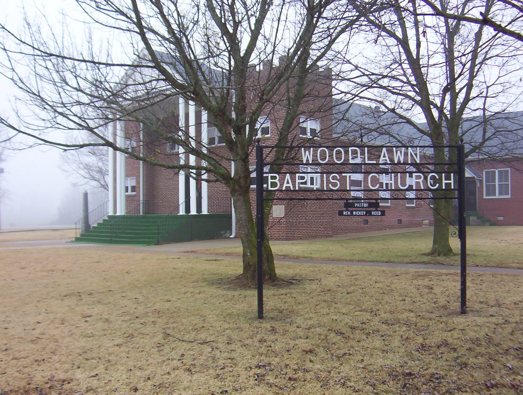
35°33′51″N 89°06′02″W / 35.564167°N 89.100556°WWoodland 9 Woodlawn Baptist Church and Cemetery 
December 2, 1996 Woodlawn Rd., east of State Route 19
35°39′16″N 89°19′16″W / 35.654444°N 89.321111°WNutbush 10 Zion Church November 21, 1978 College and Washington Sts.
35°35′44″N 89°15′42″W / 35.595556°N 89.261667°WBrownsville See also
- List of National Historic Landmarks in Tennessee
- National Register of Historic Places listings in Tennessee
References
- ^ The latitude and longitude information provided in this table was derived originally from the National Register Information System, which has been found to be fairly accurate for about 99% of listings. For about 1% of NRIS original coordinates, experience has shown that one or both coordinates are typos or otherwise extremely far off; some corrections may have been made. A more subtle problem causes many locations to be off by up to 150 yards, depending on location in the country: most NRIS coordinates were derived from tracing out latitude and longitudes off of USGS topographical quadrant maps created under North American Datum of 1927, which differs from the current, highly accurate GPS system used by Google maps. Chicago is about right, but NRIS longitudes in Washington are higher by about 4.5 seconds, and are lower by about 2.0 seconds in Maine. Latitudes differ by about 1.0 second in Florida. Some locations in this table may have been corrected to current GPS standards.
- ^ "National Register of Historic Places: Weekly List Actions". National Park Service, United States Department of the Interior. Retrieved on November 10, 2011.
- ^ Numbers represent an ordering by significant words. Various colorings, defined here, differentiate National Historic Landmark sites and National Register of Historic Places Districts from other NRHP buildings, structures, sites or objects.
- ^ "National Register Information System". National Register of Historic Places. National Park Service. . http://nrhp.focus.nps.gov/natreg/docs/All_Data.html.
U.S. National Register of Historic Places Topics Lists by states Alabama • Alaska • Arizona • Arkansas • California • Colorado • Connecticut • Delaware • Florida • Georgia • Hawaii • Idaho • Illinois • Indiana • Iowa • Kansas • Kentucky • Louisiana • Maine • Maryland • Massachusetts • Michigan • Minnesota • Mississippi • Missouri • Montana • Nebraska • Nevada • New Hampshire • New Jersey • New Mexico • New York • North Carolina • North Dakota • Ohio • Oklahoma • Oregon • Pennsylvania • Rhode Island • South Carolina • South Dakota • Tennessee • Texas • Utah • Vermont • Virginia • Washington • West Virginia • Wisconsin • WyomingLists by territories Lists by associated states Other  Category:National Register of Historic Places •
  Portal:National Register of Historic Places
Municipalities and communities of Haywood County, Tennessee County seat: Brownsville City 
Town Unincorporated
communityBelle Eagle | Nutbush
Categories:- National Register of Historic Places in Tennessee by county
- Haywood County, Tennessee
- Buildings and structures in Haywood County, Tennessee
-
Wikimedia Foundation. 2010.