- National Register of Historic Places listings in Stewart County, Tennessee
-
 Location of Stewart County in Tennessee
This is a list of the National Register of Historic Places listings in Stewart County, Tennessee.
This is intended to be a complete list of the properties and districts on the National Register of Historic Places in Stewart County, Tennessee, United States. Latitude and longitude coordinates are provided for many National Register properties and districts; these locations may be seen together in a Google map.[1]
There are 15 properties and districts listed on the National Register in the county.
Contents: Counties in Tennessee Anderson – Bedford – Benton – Bledsoe – Blount – Bradley – Campbell – Cannon – Carroll – Carter – Cheatham – Chester – Claiborne – Clay – Cocke – Coffee – Crockett – Cumberland – Davidson – Decatur – DeKalb – Dickson – Dyer – Fayette – Fentress – Franklin – Gibson – Giles – Grainger – Greene – Grundy – Hamblen – Hamilton – Hancock – Hardeman – Hardin – Hawkins – Haywood – Henderson – Henry – Hickman – Houston – Humphreys – Jackson – Jefferson – Johnson – Knox – Lake – Lauderdale – Lawrence – Lewis – Lincoln – Loudon – Macon – Madison – Marion – Marshall – Maury – McMinn – McNairy – Meigs – Monroe – Montgomery – Moore – Morgan – Obion – Overton – Perry – Pickett – Polk – Putnam – Rhea – Roane – Robertson – Rutherford – Scott – Sequatchie – Sevier – Shelby – Smith – Stewart – Sullivan – Sumner – Tipton – Trousdale – Unicoi – Union – Van Buren – Warren – Washington – Wayne – Weakley – White – Williamson – Wilson -
- This National Park Service list is complete through NPS recent listings posted November 10, 2011.[2]
Current listings
[3] Landmark name [4] Image Date listed Location City or town Summary 1 Bear Spring Furnace (40SW207) 
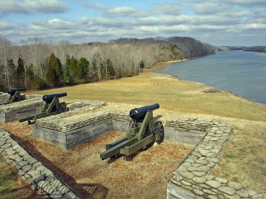
April 9, 1988 Address Restricted Dover 2 Bellwood Furnace (40SW210) April 21, 1988 Address Restricted Bumpus Mills 3 Brunsoni Furnace (40SW219) April 11, 1988 Address Restricted Cumberland City 4 Clark Furnace (40SW212) April 11, 1988 Address Restricted Standing Rock 5 Cross Creek Furnace (40SW217) April 11, 1988 Address Restricted Indian Mound 6 Dover Flint Quarries May 7, 1973 Address Restricted Dover 7 Eclipse Furnace (40SW213) April 11, 1988 Address Restricted McKinnon 8 Fort Donelson National Battlefield 
October 15, 1966 1 mile west of Dover on U.S. Route 79
36°29′14″N 87°51′07″W / 36.487222°N 87.851944°WDover 9 Fort Henry Site October 10, 1975 Northwest of Dover off U.S. Route 79 on Fort Henry Rd.
36°30′20″N 88°01′45″W / 36.505556°N 88.029167°WDover 10 Great Western Furnace October 6, 1975 Northwest of Dover on State Route 49
36°38′24″N 87°58′32″W / 36.64°N 87.975556°WDover 11 Henry Hollister House April 9, 1988 Chapel Ridge Rd.
36°22′56″N 87°40′28″W / 36.382222°N 87.674444°WCumberland City 12 LaGrange Furnace (40SW214) April 21, 1988 Address Restricted McKinnon 13 Rough and Ready Furnace (40SW215) April 9, 1988 Address Restricted Cumberland City 14 Saline Furnace (40SW218) April 9, 1988 Address Restricted Bumpus Mills 15 Samuel Stacker House April 11, 1988 Long Branch Rd.
36°27′39″N 87°47′42″W / 36.460833°N 87.795°WDover See also
- List of National Historic Landmarks in Tennessee
- National Register of Historic Places listings in Tennessee
References
- ^ The latitude and longitude information provided in this table was derived originally from the National Register Information System, which has been found to be fairly accurate for about 99% of listings. For about 1% of NRIS original coordinates, experience has shown that one or both coordinates are typos or otherwise extremely far off; some corrections may have been made. A more subtle problem causes many locations to be off by up to 150 yards, depending on location in the country: most NRIS coordinates were derived from tracing out latitude and longitudes off of USGS topographical quadrant maps created under the North American Datum of 1927, which differs from the current, highly accurate WGS84 GPS system used by Google maps. Chicago is about right, but NRIS longitudes in Washington are higher by about 4.5 seconds, and are lower by about 2.0 seconds in Maine. Latitudes differ by about 1.0 second in Florida. Some locations in this table may have been corrected to current GPS standards.
- ^ "National Register of Historic Places: Weekly List Actions". National Park Service, United States Department of the Interior. Retrieved on November 10, 2011.
- ^ Numbers represent an ordering by significant words. Various colorings, defined here, differentiate National Historic Landmark sites and National Register of Historic Places Districts from other NRHP buildings, structures, sites or objects.
- ^ "National Register Information System". National Register of Historic Places. National Park Service. . http://nrhp.focus.nps.gov/natreg/docs/All_Data.html.
U.S. National Register of Historic Places Topics Lists by states Alabama • Alaska • Arizona • Arkansas • California • Colorado • Connecticut • Delaware • Florida • Georgia • Hawaii • Idaho • Illinois • Indiana • Iowa • Kansas • Kentucky • Louisiana • Maine • Maryland • Massachusetts • Michigan • Minnesota • Mississippi • Missouri • Montana • Nebraska • Nevada • New Hampshire • New Jersey • New Mexico • New York • North Carolina • North Dakota • Ohio • Oklahoma • Oregon • Pennsylvania • Rhode Island • South Carolina • South Dakota • Tennessee • Texas • Utah • Vermont • Virginia • Washington • West Virginia • Wisconsin • WyomingLists by territories Lists by associated states Other Municipalities and communities of Stewart County, Tennessee City 
Towns Unincorporated
communityFootnotes ‡This populated place also has portions in an adjacent county or counties
Categories:- National Register of Historic Places in Tennessee by county
- Stewart County, Tennessee
- Buildings and structures in Stewart County, Tennessee
-

Wikimedia Foundation. 2010.