- National Register of Historic Places listings in Rutherford County, Tennessee
-
 Location of Rutherford County in Tennessee
This is a list of the National Register of Historic Places listings in Rutherford County, Tennessee.
This is intended to be a complete list of the properties and districts on the National Register of Historic Places in Rutherford County, Tennessee, United States. Latitude and longitude coordinates are provided for many National Register properties and districts; these locations may be seen together in a Google map.[1]
There are 46 properties and districts listed on the National Register in the county.
Contents: Counties in Tennessee Anderson – Bedford – Benton – Bledsoe – Blount – Bradley – Campbell – Cannon – Carroll – Carter – Cheatham – Chester – Claiborne – Clay – Cocke – Coffee – Crockett – Cumberland – Davidson – Decatur – DeKalb – Dickson – Dyer – Fayette – Fentress – Franklin – Gibson – Giles – Grainger – Greene – Grundy – Hamblen – Hamilton – Hancock – Hardeman – Hardin – Hawkins – Haywood – Henderson – Henry – Hickman – Houston – Humphreys – Jackson – Jefferson – Johnson – Knox – Lake – Lauderdale – Lawrence – Lewis – Lincoln – Loudon – Macon – Madison – Marion – Marshall – Maury – McMinn – McNairy – Meigs – Monroe – Montgomery – Moore – Morgan – Obion – Overton – Perry – Pickett – Polk – Putnam – Rhea – Roane – Robertson – Rutherford – Scott – Sequatchie – Sevier – Shelby – Smith – Stewart – Sullivan – Sumner – Tipton – Trousdale – Unicoi – Union – Van Buren – Warren – Washington – Wayne – Weakley – White – Williamson – Wilson -
- This National Park Service list is complete through NPS recent listings posted November 10, 2011.[2]
Current listings
[3] Landmark name [4] Image Date listed Location City or town Summary 1 Allen Chapel A.M.E. Church March 31, 1995 224 S. Maney Ave.
35°50′38″N 86°23′14″W / 35.843889°N 86.387222°WMurfreesboro 2 Arnold-Harrell House March 27, 1992 1710 E. Main St.
35°50′26″N 86°21′51″W / 35.840556°N 86.364167°WMurfreesboro 3 Beesley Primitive Baptist Church April 8, 1999 461 Beesley Rd.
35°51′11″N 86°29′51″W / 35.853056°N 86.4975°WMurfreesboro 4 Thomas C. Black House July 5, 1996 4431 Lebanon Rd.
35°55′38″N 86°22′58″W / 35.927222°N 86.382778°WMurfreesboro 5 Boxwood October 25, 1984 Old Salem Pike
35°48′37″N 86°27′09″W / 35.810278°N 86.4525°WMurfreesboro 6 Bradley Academy 
June 14, 1990 415 S. Academy St.
35°50′31″N 86°23′19″W / 35.841944°N 86.388611°WMurfreesboro School established 1811; current building completed in 1917 7 Caff-E-Hill Farm April 14, 1995 3783 Cripple Creek Rd.
35°46′42″N 86°11′53″W / 35.778333°N 86.198056°WReadyville 8 Childress-Ray House 
December 27, 1979 225 N. Academy St.
35°50′51″N 86°23′19″W / 35.8475°N 86.388611°WMurfreesboro Originally built 1847; remodeled 1874 9 Collier-Crichlow House 
July 16, 1973 511 E. Main St.
35°50′42″N 86°22′18″W / 35.845°N 86.371667°WMurfreesboro Second Empire-style house built in 1879 10 Collier-Lane-Crichlow House 
August 23, 1978 500 N. Spring St.
35°51′00″N 86°23′21″W / 35.85°N 86.389167°WMurfreesboro Commonly called the "House of Mayors"; built in 1850 11 Sam Davis House December 23, 1969 Northeast of Smyrna off State Route 102
35°59′21″N 86°29′56″W / 35.989167°N 86.498889°WSmyrna 12 Dement House June 26, 1986 Cainsville Pike
35°55′56″N 86°16′01″W / 35.932222°N 86.266944°WLascassas 13 East Main Street Historic District July 11, 1985 Roughly E. Main, E. Lytle, College, University, and E. Vine Sts.
35°50′42″N 86°22′50″W / 35.845°N 86.380556°WMurfreesboro 14 Elmwood October 15, 1973 Northwest of Murfreesboro off U.S. Routes 41/70S; also 5722 Old Nashville Highway
35°53′46″N 86°27′28″W / 35.896111°N 86.457778°WMurfreesboro 5722 Old Nashville Highway represents a boundary increase of July 3, 2007 15 First Presbyterian Church 
June 24, 1993 210 N. Spring St.
35°50′49″N 86°23′23″W / 35.846944°N 86.389722°WMurfreesboro 16 Fortress Rosecrans Site June 7, 1974 West of Murfreesboro at the Stones River
35°51′12″N 86°24′41″W / 35.853333°N 86.411389°WMurfreesboro 17 Logan Henderson Farm September 25, 2003 3600 Manchester Pike
35°47′27″N 86°21′25″W / 35.790833°N 86.356944°WMurfreesboro 18 Idler's Retreat May 19, 2004 112 Oak St.
35°59′15″N 86°30′55″W / 35.9875°N 86.515278°WSmyrna 19 Jarman Farm July 6, 1987 Cainsville Pike
35°57′46″N 86°15′30″W / 35.962778°N 86.258333°WLascassas 20 Enoch H. Jones House August 25, 1995 6339 Halls Hill Pike
35°51′39″N 86°13′04″W / 35.860833°N 86.217778°WMurfreesboro 21 William B. Jordan Farm July 13, 1992 2665 Taylor Ln.
35°46′03″N 86°36′10″W / 35.7675°N 86.602778°WEagleville 22 Landsberger-Gerhardt House December 13, 1993 435 N. Spring St.
35°51′00″N 86°23′21″W / 35.85°N 86.389167°WMurfreesboro 23 Uncle Dave Macon House November 15, 1973 West of Readyville on U.S. Route 70S
35°49′27″N 86°14′27″W / 35.824167°N 86.240833°WReadyville 24 Marymont October 30, 1973 Southwest of Murfreesboro, off State Route 99 on Rucker Lane
35°49′12″N 86°28′45″W / 35.82°N 86.479167°WMurfreesboro 25 William Harrison McCord House December 20, 1984 U.S. Route 41A
35°44′46″N 86°39′06″W / 35.746111°N 86.651667°WEagleville 26 McGill – Becton – Cates Family Farm November 9, 2005 2432 Cripple Creek Rd.
35°47′03″N 86°12′41″W / 35.784167°N 86.211389°WReadyville 27 Middle Tennessee State Teachers College Training School January 4, 1993 923 E. Lytle St.
35°50′49″N 86°22′31″W / 35.846944°N 86.375278°WMurfreesboro 28 Morgan House December 27, 1979 Southwest of Christiana
35°39′22″N 86°27′27″W / 35.656111°N 86.4575°WChristiana 29 Murray Farm July 31, 1991 9409 Bradyville Rd.
35°45′21″N 86°15′49″W / 35.755833°N 86.263611°WReadyville 30 North Maney Avenue Historic District April 4, 1985 Roughly bounded by N. Maney and N. Highland Aves., E. College St., and N. Academy Ave.
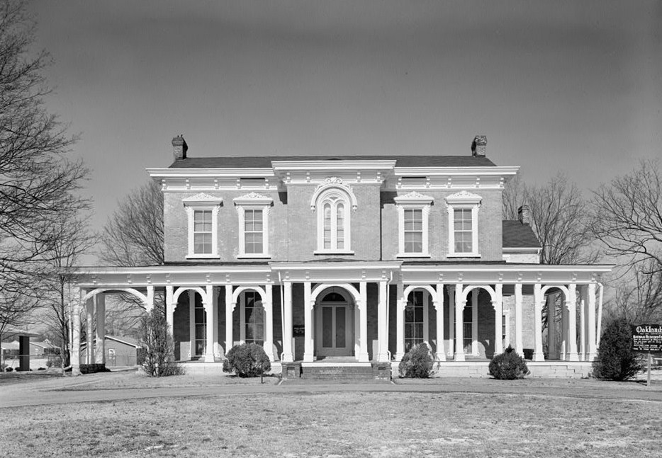
35°50′55″N 86°23′10″W / 35.848611°N 86.386111°WMurfreesboro 31 Oaklands 
February 26, 1970 N. Maney Ave.
35°51′21″N 86°23′06″W / 35.855833°N 86.385°WMurfreesboro 32 Gen. Joseph B. Palmer House 
September 20, 1973 434 E. Main St.
35°50′43″N 86°23′07″W / 35.845278°N 86.385278°WMurfreesboro Built in 1869 by Confederate general Joseph B. Palmer (1825–1890) 33 Providence Primitive Baptist Church November 8, 2000 256 Central Valley Rd.
35°56′19″N 86°22′51″W / 35.938611°N 86.380833°WWalterhill 34 Charles Ready House July 2, 1973 On U.S. Route 70S
35°49′45″N 86°10′47″W / 35.829167°N 86.179722°WReadyville 35 Riverside Farm December 12, 2006 1218 W. Jefferson Pike
35°57′55″N 86°23′21″W / 35.965278°N 86.389167°WWalterhill 36 Rockvale Store September 14, 1995 8964 Rockvale Rd.
35°45′27″N 86°31′53″W / 35.7575°N 86.531389°WRockvale 37 Benjamine Rucker House February 28, 1991 3978 Betty Ford Rd.
35°55′14″N 86°19′51″W / 35.920556°N 86.330833°WCompton 38 Rutherford County Courthouse 
July 16, 1973 Public Square
35°50′46″N 86°23′31″W / 35.846111°N 86.391944°WMurfreesboro 39 Rutherford Health Department July 24, 1992 303 N. Church St.
35°50′54″N 86°23′27″W / 35.848333°N 86.390833°WMurfreesboro 40 Absalom Scales House October 30, 1973 North of Eagleville off State Route 16, on Rocky Glade Rd.
35°46′27″N 86°38′22″W / 35.774167°N 86.639444°WEagleville 41 Searcy – Matthews – Tarpley Farm July 14, 2011 455 W. Jefferson Pike
35°57′08″N 86°23′07″W / 35.952222°N 86.385278°WWalterhill Historic Family Farms in Middle Tennessee MPS 42 Robert Andrew Smith Farm January 4, 1993 2568 Armstrong Valley Rd.
35°46′06″N 86°28′45″W / 35.768333°N 86.479167°WMurfreesboro 43 John C. Spence House August 23, 2004 503 N. Maple St.
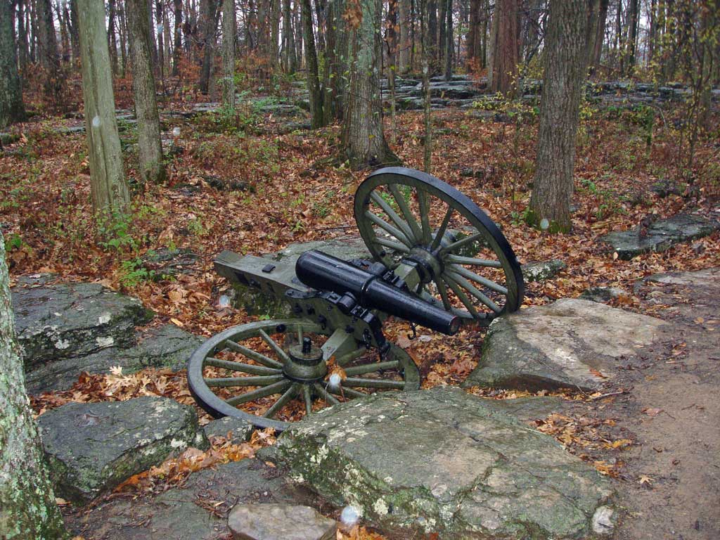
35°51′10″N 86°23′32″W / 35.852778°N 86.392222°WMurfreesboro 44 Stones River National Battlefield 
October 15, 1966 3 miles northwest of Murfreesboro on U.S. Route 41
35°52′24″N 86°25′17″W / 35.873333°N 86.421389°WMurfreesboro 45 Walter Hill Hydroelectric Station November 7, 1990 U.S. Route 231 at the Stones River
35°56′37″N 86°22′37″W / 35.943611°N 86.376944°WMurfreesboro 46 Thomas Williamson House June 21, 1996 2263 Little Rock Rd.
35°44′58″N 86°37′17″W / 35.749444°N 86.621389°WEagleville See also
- List of National Historic Landmarks in Tennessee
- National Register of Historic Places listings in Tennessee
References
- ^ The latitude and longitude information provided in this table was derived originally from the National Register Information System, which has been found to be fairly accurate for about 99% of listings. For about 1% of NRIS original coordinates, experience has shown that one or both coordinates are typos or otherwise extremely far off; some corrections may have been made. A more subtle problem causes many locations to be off by up to 150 yards, depending on location in the country: most NRIS coordinates were derived from tracing out latitude and longitudes off of USGS topographical quadrant maps created under North American Datum of 1927, which differs from the current, highly accurate GPS system used by Google maps. Chicago is about right, but NRIS longitudes in Washington are higher by about 4.5 seconds, and are lower by about 2.0 seconds in Maine. Latitudes differ by about 1.0 second in Florida. Some locations in this table may have been corrected to current GPS standards.
- ^ "National Register of Historic Places: Weekly List Actions". National Park Service, United States Department of the Interior. Retrieved on November 10, 2011.
- ^ Numbers represent an ordering by significant words. Various colorings, defined here, differentiate National Historic Landmark sites and National Register of Historic Places Districts from other NRHP buildings, structures, sites or objects.
- ^ "National Register Information System". National Register of Historic Places. National Park Service. . http://nrhp.focus.nps.gov/natreg/docs/All_Data.html.
U.S. National Register of Historic Places Topics Lists by states Alabama • Alaska • Arizona • Arkansas • California • Colorado • Connecticut • Delaware • Florida • Georgia • Hawaii • Idaho • Illinois • Indiana • Iowa • Kansas • Kentucky • Louisiana • Maine • Maryland • Massachusetts • Michigan • Minnesota • Mississippi • Missouri • Montana • Nebraska • Nevada • New Hampshire • New Jersey • New Mexico • New York • North Carolina • North Dakota • Ohio • Oklahoma • Oregon • Pennsylvania • Rhode Island • South Carolina • South Dakota • Tennessee • Texas • Utah • Vermont • Virginia • Washington • West Virginia • Wisconsin • WyomingLists by territories Lists by associated states Other  Category:National Register of Historic Places •
  Portal:National Register of Historic Places
Municipalities and communities of Rutherford County, Tennessee County seat: Murfreesboro Cities 
Town CDP Unincorporated
communitiesFootnotes ‡This populated place also has portions in an adjacent county or counties
Categories:- National Register of Historic Places in Tennessee by county
- Rutherford County, Tennessee
- Buildings and structures in Rutherford County, Tennessee
-


Wikimedia Foundation. 2010.