- National Register of Historic Places listings in Robertson County, Tennessee
-
 Location of Robertson County in Tennessee
This is a list of the National Register of Historic Places listings in Robertson County, Tennessee.
This is intended to be a complete list of the properties and districts on the National Register of Historic Places in Robertson County, Tennessee, United States. Latitude and longitude coordinates are provided for many National Register properties and districts; these locations may be seen together in a Google map.[1]
There are 24 properties and districts listed on the National Register in the county.
Contents: Counties in Tennessee Anderson – Bedford – Benton – Bledsoe – Blount – Bradley – Campbell – Cannon – Carroll – Carter – Cheatham – Chester – Claiborne – Clay – Cocke – Coffee – Crockett – Cumberland – Davidson – Decatur – DeKalb – Dickson – Dyer – Fayette – Fentress – Franklin – Gibson – Giles – Grainger – Greene – Grundy – Hamblen – Hamilton – Hancock – Hardeman – Hardin – Hawkins – Haywood – Henderson – Henry – Hickman – Houston – Humphreys – Jackson – Jefferson – Johnson – Knox – Lake – Lauderdale – Lawrence – Lewis – Lincoln – Loudon – Macon – Madison – Marion – Marshall – Maury – McMinn – McNairy – Meigs – Monroe – Montgomery – Moore – Morgan – Obion – Overton – Perry – Pickett – Polk – Putnam – Rhea – Roane – Robertson – Rutherford – Scott – Sequatchie – Sevier – Shelby – Smith – Stewart – Sullivan – Sumner – Tipton – Trousdale – Unicoi – Union – Van Buren – Warren – Washington – Wayne – Weakley – White – Williamson – Wilson -
- This National Park Service list is complete through NPS recent listings posted November 10, 2011.[2]
Current listings
[3] Landmark name [4] Image Date listed Location City or town Summary 1 The Beeches March 25, 1982 State Route 49
36°31′15″N 86°51′18″W / 36.520833°N 86.855°WSpringfield 2 Bell Witch Cave March 21, 2008 430 Keysburg Rd.
36°35′29″N 87°03′20″W / 36.591389°N 87.055556°WAdams 3 Cornsilk January 11, 1974 North of Cross Plains on Highland Rd.
36°38′06″N 86°37′54″W / 36.635°N 86.631667°WCross Plains 4 Glen Raven 
October 2, 1973 Southwest of Cedar Hill on Washington Rd.
36°31′53″N 87°04′11″W / 36.531389°N 87.069722°WCedar Hill 5 Highland Chapel Union Church October 29, 1991 Highland Ave.
36°23′41″N 86°46′29″W / 36.394722°N 86.774722°WRidgetop 6 Mansfield Cheatham House January 30, 1978 7th Ave., W.
36°30′35″N 86°53′29″W / 36.509722°N 86.891389°WSpringfield 7 Nelson's Greenbrier Distillery July 24, 2008 Main St. west of Greenbrier Cemetery Rd. Greenbrier 8 George O'Bryan House February 23, 1989 O'Bryan and Highland Aves.
36°23′43″N 86°46′24″W / 36.395278°N 86.773333°WRidgetop 9 Arthur Pitt House and Distillery December 18, 1973 Northeast of Springfield off State Route 49
36°32′41″N 86°48′53″W / 36.544722°N 86.814722°WSpringfield 10 William Randolph House October 30, 1973 On State Route 25
36°32′54″N 86°41′52″W / 36.548333°N 86.697778°WCross Plains 11 Red River Blockhouse Number 1 November 15, 2003 5461 U.S. Route 41
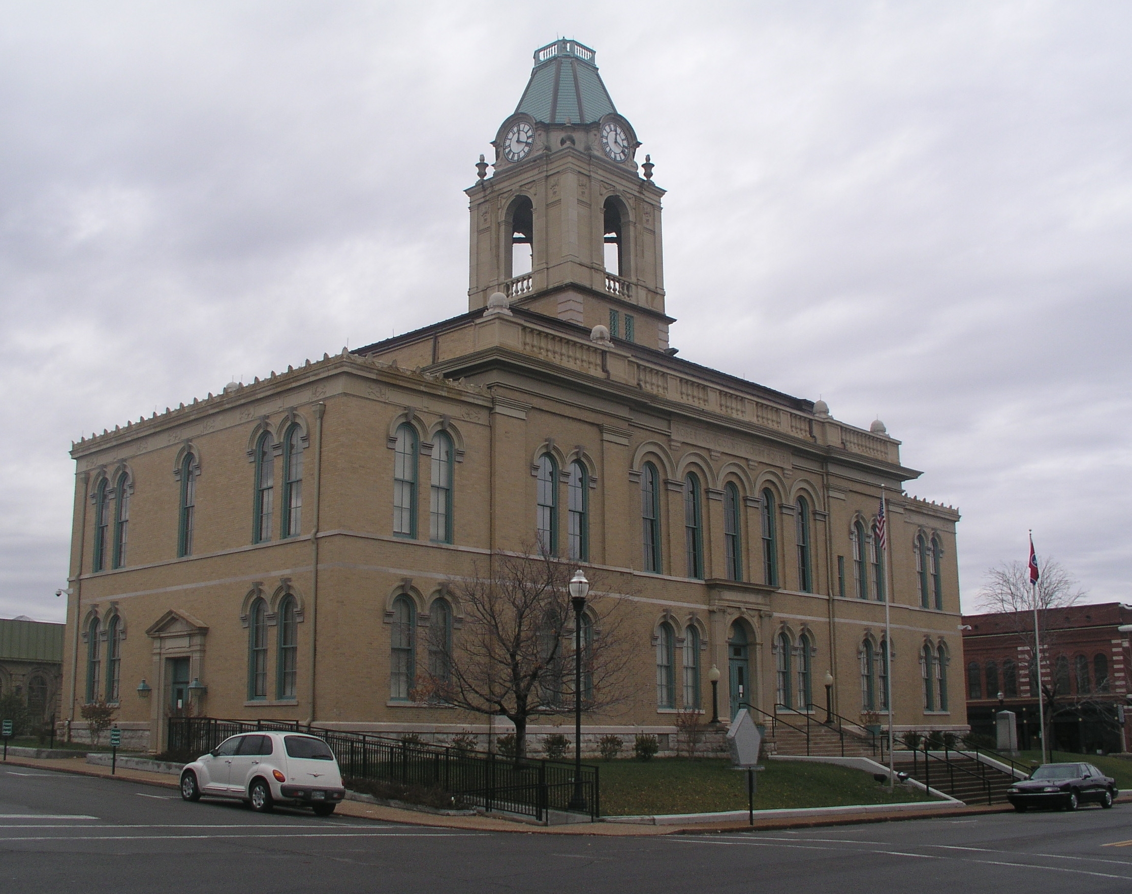
36°35′22″N 87°04′58″W / 36.589444°N 87.082778°WAdams 12 Robertson County Courthouse 
May 22, 1978 Public Sq.
36°30′08″N 86°53′08″W / 36.502222°N 86.885556°WSpringfield 13 Rock Jolly October 30, 1973 Northeast of Cross Plains off State Route 52 Cross Plains 14 St. Michael's Catholic Church July 5, 1973 3.5 miles west of State Route 49
36°29′14″N 86°59′56″W / 36.487222°N 86.998889°WCedar Hill 15 Springfield Town Square Historic District August 1, 1979 U.S. Route 41 and State Route 49
36°30′31″N 86°53′07″W / 36.508611°N 86.885278°WSpringfield 16 Granville Babb Sprouse House October 30, 1998 205 W. College St.
36°25′38″N 86°48′22″W / 36.427222°N 86.806111°WGreenbrier 17 Strickland Place Farm March 31, 2010 7724-7726 Highway 76 East
36°28′35″N 86°42′27″W / 36.476478°N 86.707464°WWhite House 18 Sudley Place January 11, 1974 North of Youngfield on State Line Rd.
36°38′40″N 86°48′56″W / 36.644444°N 86.815556°WYoungville 19 Thomas Drugs November 4, 1993 7802 State Route 25, E.
36°32′55″N 86°41′48″W / 36.548611°N 86.696667°WCross Plains 20 Dr. Martin Walton House November 20, 1996 6360 State Route 25, E.
36°33′14″N 86°47′09″W / 36.553889°N 86.785833°WSpringfield 21 Walton-Wiggins Farm August 8, 1997 4020 Woodrow Wilson Rd.
36°31′12″N 86°44′05″W / 36.52°N 86.734722°WSpringfield 22 Wessyngton May 6, 1971 South of Cedar Hill
36°30′05″N 87°00′14″W / 36.501389°N 87.003889°WCedar Hill 23 Woodard Hall October 10, 1975 Northeast of Springfield on Owens Chapel Rd.; also 5876 Owens Chapel Rd.
36°32′04″N 86°49′18″W / 36.534444°N 86.821667°WSpringfield 5876 Owens Chapel represents a boundary increase of April 28, 1995 24 Thomas Woodard, Jr. Farm April 8, 2008 5024 Ogg Rd.
36°34′15″N 86°56′13″W / 36.57071°N 86.93692°WCedar Hill See also
- List of National Historic Landmarks in Tennessee
- National Register of Historic Places listings in Tennessee
References
- ^ The latitude and longitude information provided in this table was derived originally from the National Register Information System, which has been found to be fairly accurate for about 99% of listings. For about 1% of NRIS original coordinates, experience has shown that one or both coordinates are typos or otherwise extremely far off; some corrections may have been made. A more subtle problem causes many locations to be off by up to 150 yards, depending on location in the country: most NRIS coordinates were derived from tracing out latitude and longitudes off of USGS topographical quadrant maps created under the North American Datum of 1927, which differs from the current, highly accurate WGS84 GPS system used by Google maps. Chicago is about right, but NRIS longitudes in Washington are higher by about 4.5 seconds, and are lower by about 2.0 seconds in Maine. Latitudes differ by about 1.0 second in Florida. Some locations in this table may have been corrected to current GPS standards.
- ^ "National Register of Historic Places: Weekly List Actions". National Park Service, United States Department of the Interior. Retrieved on November 10, 2011.
- ^ Numbers represent an ordering by significant words. Various colorings, defined here, differentiate National Historic Landmark sites and National Register of Historic Places Districts from other NRHP buildings, structures, sites or objects.
- ^ "National Register Information System". National Register of Historic Places. National Park Service. . http://nrhp.focus.nps.gov/natreg/docs/All_Data.html.
U.S. National Register of Historic Places Topics Lists by states Alabama • Alaska • Arizona • Arkansas • California • Colorado • Connecticut • Delaware • Florida • Georgia • Hawaii • Idaho • Illinois • Indiana • Iowa • Kansas • Kentucky • Louisiana • Maine • Maryland • Massachusetts • Michigan • Minnesota • Mississippi • Missouri • Montana • Nebraska • Nevada • New Hampshire • New Jersey • New Mexico • New York • North Carolina • North Dakota • Ohio • Oklahoma • Oregon • Pennsylvania • Rhode Island • South Carolina • South Dakota • Tennessee • Texas • Utah • Vermont • Virginia • Washington • West Virginia • Wisconsin • WyomingLists by territories Lists by associated states Other Municipalities and communities of Robertson County, Tennessee Cities Adams | Cedar Hill | Cross Plains | Millersville‡ | Orlinda | Portland‡ | Springfield | White House‡ | Ridgetop‡

Towns Unincorporated
communityFootnotes ‡This populated place also has portions in an adjacent county or counties
Categories:- National Register of Historic Places in Tennessee by county
- Robertson County, Tennessee
- Buildings and structures in Robertson County, Tennessee
-

Wikimedia Foundation. 2010.