- National Register of Historic Places listings in Marion County, Tennessee
-
 Location of Marion County in Tennessee
This is a list of the National Register of Historic Places listings in Marion County, Tennessee.
This is intended to be a complete list of the properties and districts on the National Register of Historic Places in Marion County, Tennessee, United States. Latitude and longitude coordinates are provided for many National Register properties and districts; these locations may be seen together in a Google map.[1]
There are 14 properties and districts listed on the National Register in the county.
Contents: Counties in Tennessee Anderson – Bedford – Benton – Bledsoe – Blount – Bradley – Campbell – Cannon – Carroll – Carter – Cheatham – Chester – Claiborne – Clay – Cocke – Coffee – Crockett – Cumberland – Davidson – Decatur – DeKalb – Dickson – Dyer – Fayette – Fentress – Franklin – Gibson – Giles – Grainger – Greene – Grundy – Hamblen – Hamilton – Hancock – Hardeman – Hardin – Hawkins – Haywood – Henderson – Henry – Hickman – Houston – Humphreys – Jackson – Jefferson – Johnson – Knox – Lake – Lauderdale – Lawrence – Lewis – Lincoln – Loudon – Macon – Madison – Marion – Marshall – Maury – McMinn – McNairy – Meigs – Monroe – Montgomery – Moore – Morgan – Obion – Overton – Perry – Pickett – Polk – Putnam – Rhea – Roane – Robertson – Rutherford – Scott – Sequatchie – Sevier – Shelby – Smith – Stewart – Sullivan – Sumner – Tipton – Trousdale – Unicoi – Union – Van Buren – Warren – Washington – Wayne – Weakley – White – Williamson – Wilson -
- This National Park Service list is complete through NPS recent listings posted November 10, 2011.[2]
Current listings
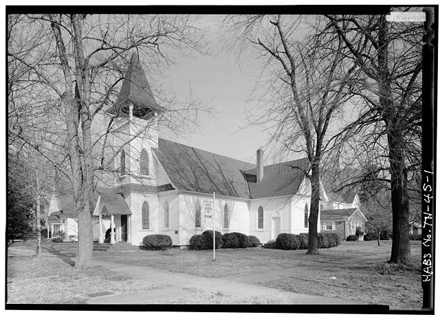
[3] Landmark name [4] Image Date listed Location City or town Summary 1 Christ Episcopal Church and Parish House 
August 22, 1977 Corner of 3rd and Holly Sts.
35°00′48″N 85°42′26″W / 35.013333°N 85.707222°WSouth Pittsburg 2 First National Bank of South Pittsburg June 24, 1991 204 W. 3rd St.
35°00′46″N 85°42′23″W / 35.012778°N 85.706389°WSouth Pittsburg 3 Hale's Bar Dam Powerhouse 
November 25, 2008 1265 Hale's Bar Rd. Haletown 4 Richard Hardy Memorial School September 30, 1982 1620 Hamilton Ave.
34°59′43″N 85°43′14″W / 34.995278°N 85.720556°WSouth Pittsburg 5 Kelly's Ferry Road and Cemetery November 15, 2006 U.S. Route 41 near Kelly's Ferry Church of God
35°02′13″N 85°25′33″W / 35.036944°N 85.425833°WGuild 6 Ketner's Mill and Bridge 
November 23, 1977 East of Victoria on Ketner Mill Rd. and at the Sequatchie River
35°08′19″N 85°31′08″W / 35.138611°N 85.518889°WVictoria 7 Marion Memorial Bridge 
September 6, 2007 U.S. Route 41 at Nickajack Lake
35°01′39″N 85°32′32″W / 35.0275°N 85.542222°WHaletown 8 McKendree Methodist Episcopal Church November 21, 1978 Betsy Pack Dr.
35°04′40″N 85°37′33″W / 35.077778°N 85.625833°WJasper 9 McNabb Mines March 26, 2008 River Canyon Rd. between miles 438 and 439 on the Tennessee River Haletown 10 Primitive Baptist Church of Sweeten's Cove June 30, 1983 Sweden Cove Rd.
35°04′15″N 85°46′48″W / 35.070833°N 85.78°WSouth Pittsburg 11 Putnam-Cumberland Historic District of Richard City July 25, 1991 1805-1810 Cumberland and 1805-1812 Putnam Aves.
34°59′41″N 85°43′33″W / 34.994722°N 85.725833°WSouth Pittsburg 12 RyeMabee December 22, 1997 224 E. Main St.
35°14′23″N 85°49′47″W / 35.239722°N 85.829722°WMonteagle 13 South Pittsburg Historic District October 25, 1990 Roughly bounded by Elm and Walnut Aves. and 2nd and 7th Sts.; also 700-804 Elm Ave.
35°00′42″N 85°42′37″W / 35.011667°N 85.710278°WSouth Pittsburg Second set of addresses represents a boundary increase of July 11, 2001 14 Townsite Historic District of Richard City July 25, 1991 402-512 Dixie, 102-106 Lee Hunt, and 2207 Cumberland Aves.
34°59′28″N 85°43′41″W / 34.991111°N 85.728056°WSouth Pittsburg See also
- List of National Historic Landmarks in Tennessee
- National Register of Historic Places listings in Tennessee
References
- ^ The latitude and longitude information provided in this table was derived originally from the National Register Information System, which has been found to be fairly accurate for about 99% of listings. For about 1% of NRIS original coordinates, experience has shown that one or both coordinates are typos or otherwise extremely far off; some corrections may have been made. A more subtle problem causes many locations to be off by up to 150 yards, depending on location in the country: most NRIS coordinates were derived from tracing out latitude and longitudes off of USGS topographical quadrant maps created under the North American Datum of 1927, which differs from the current, highly accurate WGS84 GPS system used by Google maps. Chicago is about right, but NRIS longitudes in Washington are higher by about 4.5 seconds, and are lower by about 2.0 seconds in Maine. Latitudes differ by about 1.0 second in Florida. Some locations in this table may have been corrected to current GPS standards.
- ^ "National Register of Historic Places: Weekly List Actions". National Park Service, United States Department of the Interior. Retrieved on November 10, 2011.
- ^ Numbers represent an ordering by significant words. Various colorings, defined here, differentiate National Historic Landmark sites and National Register of Historic Places Districts from other NRHP buildings, structures, sites or objects.
- ^ "National Register Information System". National Register of Historic Places. National Park Service. . http://nrhp.focus.nps.gov/natreg/docs/All_Data.html.
U.S. National Register of Historic Places Topics Lists by states Alabama • Alaska • Arizona • Arkansas • California • Colorado • Connecticut • Delaware • Florida • Georgia • Hawaii • Idaho • Illinois • Indiana • Iowa • Kansas • Kentucky • Louisiana • Maine • Maryland • Massachusetts • Michigan • Minnesota • Mississippi • Missouri • Montana • Nebraska • Nevada • New Hampshire • New Jersey • New Mexico • New York • North Carolina • North Dakota • Ohio • Oklahoma • Oregon • Pennsylvania • Rhode Island • South Carolina • South Dakota • Tennessee • Texas • Utah • Vermont • Virginia • Washington • West Virginia • Wisconsin • WyomingLists by territories Lists by associated states Other Municipalities and communities of Marion County, Tennessee Cities 
Towns Jasper | Kimball | Monteagle‡ | Orme | Powell's Crossroads
Unincorporated
communitiesFootnotes ‡This populated place also has portions in an adjacent county or counties
Categories:- National Register of Historic Places in Tennessee by county
- Marion County, Tennessee
- Buildings and structures in Marion County, Tennessee
-


Wikimedia Foundation. 2010.