- Marion County, Tennessee
-
For counties with a similar name, see Marion County (disambiguation).
Coordinates: 35°08′N 85°37′W / 35.13°N 85.61°W
Marion County, Tennessee 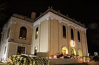 Marion County Courthouse in Jasper
Location in the state of Tennessee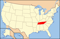
Tennessee's location in the U.S.Founded information needed Seat Jasper Largest city South Pittsburg Area
- Total
- Land
- Water
512 sq mi (1,327 km²)
498 sq mi (1,291 km²)
14 sq mi (36 km²), 2.72%Population
- (2000)
- Density
27,776
56/sq mi (22/km²)Time zone Central: UTC-6/-5 Marion County is a county located in the U.S. state of Tennessee. As of 2000, the population was 27,776. Its county seat is Jasper.[1]
Marion County is part of the Chattanooga, TN–GA Metropolitan Statistical Area.
Contents
Geography
According to the U.S. Census Bureau, the county has a total area of 512 square miles (1,327 km²), of which 498 square miles (1,291 km²) is land and 14 square miles (36 km²) (2.72%) is water.
Adjacent counties
- Grundy County (north)
- Sequatchie County (northeast)
- Hamilton County (east)
- Dade County, Georgia (southeast)
- Jackson County, Alabama (southwest)
- Franklin County (west)
History
In 1779 Cherokee chief Dragging Canoe moved down the Tennessee River from Chickamauga Creek to Running Water creek, and helped establish the associated town of Nickajack downriver in front of the entrance to Nickajack Cave. In 1794, this town was attacked and burned. This attack was led by Colonel James Orr of Nashville, Tennessee. The town was rebuilt and the Chickamauga Band of Indians continued to live here until 1838, when all remaining Indians were removed from Tennessee, Alabama, and Georgia.[2]
In the spring of 1861, Robert Cravens of Chattanooga began mining saltpeter, the main ingredient of gunpowder, at Nickajack Cave. Later this operation was taken over by the Confederate Niter Bureau. At one point, Nickajack Cave was one of the main sources of saltpeter for the Confederate States of America. Nickajack Cave was visited by thousands of Civil War troops, who moved up and down the Tennessee River on boats.[2]
Another important saltpeter mine during the Civil War was Monteagle Saltpeter Cave, located in Cave Cove, approximately 4 miles southeast of Monteagle. During the Civil War, it was referred to as Battle Creek Cave. A 1917 visitor to the cave reported 25 or 30 old hoppers remaining in the cave. (Marion O. Smith, "Confederate Niter District Eight: Middle Tennesse & Northwest Georgia, 2011, 56 pages.)
Demographics
As of the census[3] of 2000, there were 27,776 people, 11,037 households, and 8,134 families residing in the county. The population density was 56 people per square mile (22/km²). There were 12,140 housing units at an average density of 24 per square mile (9/km²). The racial makeup of the county was 94.33% White, 4.14% Black or African American, 0.26% Native American, 0.21% Asian, 0.01% Pacific Islander, 0.27% from other races, and 0.78% from two or more races. 0.73% of the population were Hispanic or Latino of any race.
 Age pyramid Marion County[4]
There were 11,037 households out of which 31.10% have children under the age of 18 living with them, 57.90% were married couples living together, 11.60% had a female householder with no husband present, and 26.30% were non-families. 23.60% of all households were made up of individuals and 10.20% had someone living alone who was 65 years of age or older. The average household size was 2.49 and the average family size was 2.93.
In the county, the population was spread out with 23.70% under the age of 18, 8.50% from 18 to 24, 28.60% from 25 to 44, 26.30% from 45 to 64, and 12.90% who were 65 years of age or older. The median age was 38 years. For every 100 females there were 95.90 males. For every 100 females age 18 and over, there were 92.00 males.
The median income for a household in the county was $31,419, and the median income for a family was $36,351. Males had a median income of $30,236 versus $21,778 for females. The per capita income for the county was $16,419. About 10.80% of families and 14.10% of the population were below the poverty line, including 20.00% of those under age 18 and 14.30% of those age 65 or over.
Cities and towns
Municipalities
- Jasper
- Kimball
- Monteagle
- New Hope
- Orme
- Powells Crossroads
- South Pittsburg
- Whiteside (formerly Running Water)
- Whitwell
Unincorporated communities
- Griffith Creek
- Haletown
- Mineral Springs
Transportation
Airport
Marion County Airport, also known as Brown Field, is a county-owned, public-use airport located four nautical miles (7 km) southeast of the central business district of Jasper.[5]
Education
The schools in Marion County are:
- Jasper Elementary School
- Jasper Middle School
- Marion County High School
- Monteagle Elementary School
- South Pittsburg Elementary
- South Pittsburg High School
- Whitwell Elementary School
- Whitwell High School
Parks and natural features
Nickajack Cave in Marion County, located 0.6 miles south of Shellmound Station on the west side of the Tennessee River, is one of the most historical caves in Tennessee.[6] It is currently part of a park run by the city of New Hope. A paved hiking trail leads to an observation deck at the entrance to the cave where visitors can watch the bats leave the cave at dusk. (Larry E. Matthews, Caves of Chattanooga, 2007, Published by the National Speleological Society, ISBN 978-1-879961-27-2.) The cave was used by tourists and as a show cave, but in 1968 the cave was flooded by the TVA. The TVA engineers became lazy with the efforts on Hales Bar Dam concerning leaks and navigation lock would be too expensive, TVA scrapped twenty years of effort by building Nickajack Dam 6 miles downstream and flooding the Nickajack Cave.
Notable people
- Cherokee Dragging Canoe, lived in the town of Running Water at the mouth of Running Water creek on the Tennessee River.
- Cherokee scholar Sequoyah (b. 1776 (?), d. 1843 ) lived in the Marion County area. Sequoyah is famous for developing a Cherokee alphabet, making the Cherokee Nation literate in their own language. A bust honoring Sequoyah is in the town of South Pittsburgh in front of the Beene Pearson Public Library.
- Artist Jon Coffelt (b. May 16, 1963) was born in Dunlap, Tennessee, raised in Griffith Creek and now lives and works in New York City.
.
See also
References
- ^ "Find a County". National Association of Counties. http://www.naco.org/Counties/Pages/FindACounty.aspx. Retrieved 2011-06-07.
- ^ a b "Caves of Chattanooga" by Larry E. Matthews, 2007, Published by the National Speleological Society, ISBN 978-1-879961-27-2
- ^ "American FactFinder". United States Census Bureau. http://factfinder.census.gov. Retrieved 2008-01-31.
- ^ Based on 2000 census data
- ^ FAA Airport Master Record for APT (Form 5010 PDF). Federal Aviation Administration. Effective 11 February 2010.
- ^ Thomas C. Barr, Jr. (Caves of Tennessee, 1961)
External links

Grundy County Sequatchie County Franklin County 
Hamilton County  Marion County, Tennessee

Jackson County, Alabama Dade County, Georgia Municipalities and communities of Marion County, Tennessee Cities 
Towns Jasper | Kimball | Monteagle‡ | Orme | Powell's Crossroads
Unincorporated
communitiesFootnotes ‡This populated place also has portions in an adjacent county or counties
Categories:- Tennessee counties
- Marion County, Tennessee
- Chattanooga metropolitan area


Wikimedia Foundation. 2010.