- National Register of Historic Places listings in Roane County, Tennessee
-
 Location of Roane County in Tennessee
This is a list of the National Register of Historic Places listings in Roane County, Tennessee.
This is intended to be a complete list of the properties and historic districts in Roane County, Tennessee, United States, that are listed on the National Register of Historic Places. Latitude and longitude coordinates are provided for many National Register properties and districts; these locations may be seen together in a Google map.[1]
There are 20 properties and districts listed on the National Register in the county, including one National Historic Landmark.
Contents: Counties in Tennessee Anderson – Bedford – Benton – Bledsoe – Blount – Bradley – Campbell – Cannon – Carroll – Carter – Cheatham – Chester – Claiborne – Clay – Cocke – Coffee – Crockett – Cumberland – Davidson – Decatur – DeKalb – Dickson – Dyer – Fayette – Fentress – Franklin – Gibson – Giles – Grainger – Greene – Grundy – Hamblen – Hamilton – Hancock – Hardeman – Hardin – Hawkins – Haywood – Henderson – Henry – Hickman – Houston – Humphreys – Jackson – Jefferson – Johnson – Knox – Lake – Lauderdale – Lawrence – Lewis – Lincoln – Loudon – Macon – Madison – Marion – Marshall – Maury – McMinn – McNairy – Meigs – Monroe – Montgomery – Moore – Morgan – Obion – Overton – Perry – Pickett – Polk – Putnam – Rhea – Roane – Robertson – Rutherford – Scott – Sequatchie – Sevier – Shelby – Smith – Stewart – Sullivan – Sumner – Tipton – Trousdale – Unicoi – Union – Van Buren – Warren – Washington – Wayne – Weakley – White – Williamson – Wilson -
- This National Park Service list is complete through NPS recent listings posted November 10, 2011.[2]
Current listings
[3] Landmark name [4] Image Date listed Location City or town Summary 1 Abston Garage 
March 10, 2009 505 Winter Gap Ave.
36°02′39″N 84°20′39″W / 36.04412°N 84.34416°WOliver Springs [1] 2 Bethel Cemetery 
June 26, 2006 Euclid Ave. and 3rd St.
35°52′16″N 84°31′02″W / 35.871111°N 84.517222°WKingston 3 Colonial Hall 
September 11, 1975 Spring and Main Sts.
36°02′39″N 84°20′26″W / 36.044167°N 84.340556°WOliver Springs Antebellum house currently being restored 4 Cornstalk Heights Historic District 
January 11, 1991 Roughly bounded by Georgia Ave., Sewanee St., Morgan Ave., and Trenton St.
35°56′03″N 84°32′48″W / 35.934167°N 84.546667°WHarriman Contains several dozen contributing houses built in the 1890s through the 1930s 5 Harriman City Hall 
April 16, 1971 Roane and Walden Sts.
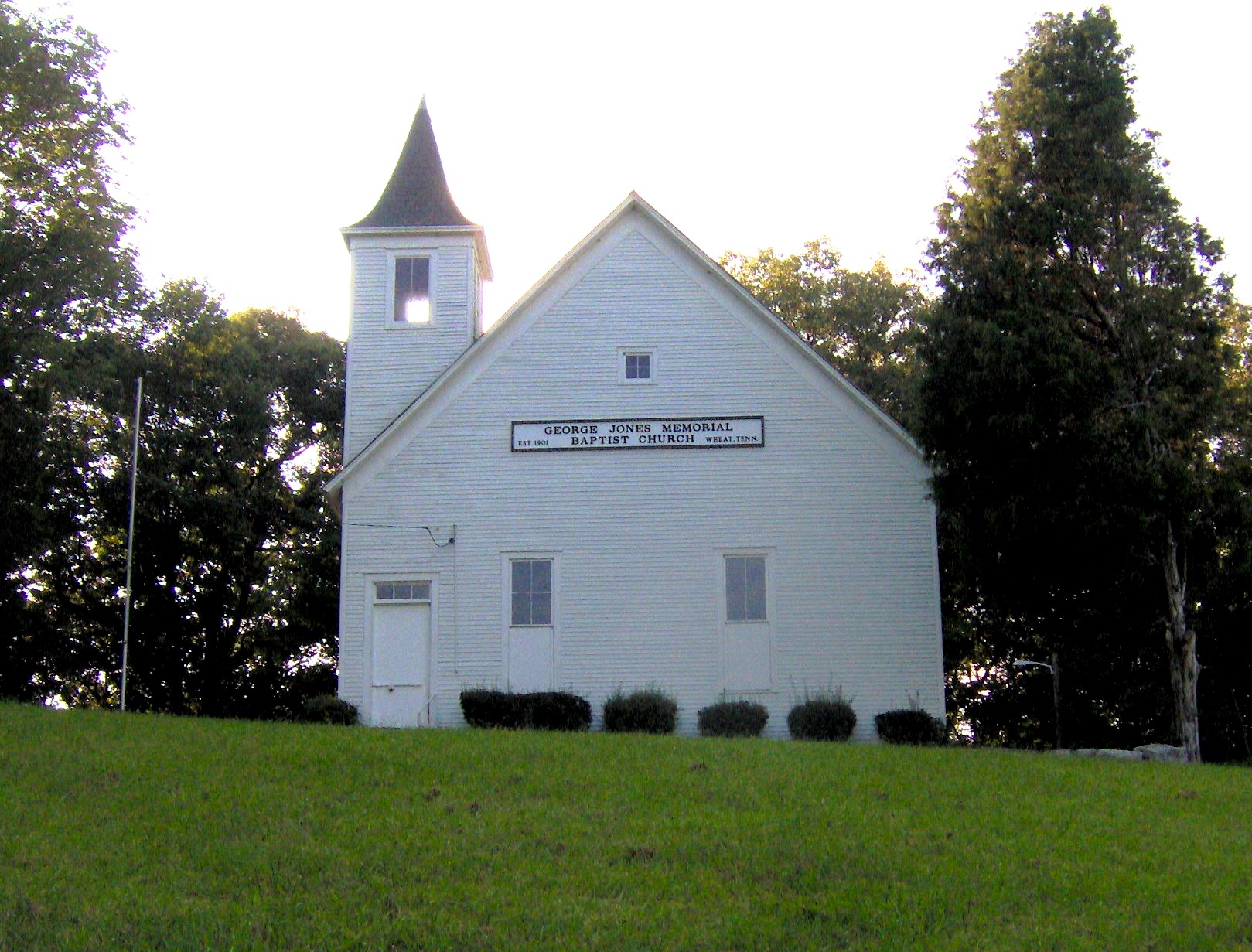
35°56′02″N 84°33′07″W / 35.933889°N 84.551944°WHarriman Building originally housed American Temperance University. 6 George Jones Memorial Baptist Church 
May 6, 1992 Blair Rd.
35°56′21″N 84°22′22″W / 35.939167°N 84.372778°WOak Ridge 7 Kingston Avenue Historic District 
December 1, 1997 Roughly along N. Kingston, S. Kingston, and E. Rockwood Aves.
35°51′56″N 84°41′04″W / 35.865556°N 84.684444°WRockwood 8 Molyneux Chevrolet Company-Rockwood Fire Department Building 
March 20, 2002 104 N. Chamberlain St.
35°52′08″N 84°41′14″W / 35.868889°N 84.687222°WRockwood 9 Col. Gideon Morgan House 
January 27, 1983 149 Kentucky St.
35°52′20″N 84°30′59″W / 35.872222°N 84.516389°WKingston 10 New Bethel Baptist Church 
May 6, 1992 Bethel Valley Rd.
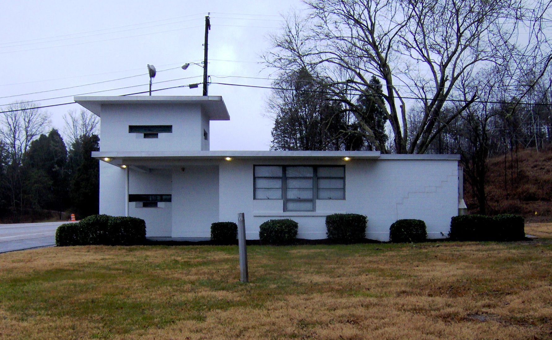
35°56′01″N 84°18′19″W / 35.933611°N 84.305278°WOak Ridge 11 Oak Ridge Turnpike Checking Station 
May 6, 1992 Oak Ridge Turnpike
35°58′49″N 84°20′03″W / 35.980278°N 84.334167°WOak Ridge One of three NRHP-listed World War II-era checkpoint gatehouses in Oak Ridge 12 Post Oak Springs Christian Church 
March 15, 2007 Roane St. Highway (Old Kingston Highway) at Post Oak Rd.
35°52′25″N 84°38′02″W / 35.873611°N 84.633889°WRockwood 13 Roane County Courthouse 
July 14, 1971 Kentucky Ave.
35°52′18″N 84°30′57″W / 35.871667°N 84.515833°WKingston Now a museum; the new courthouse is located across the street 14 Roane Street Commercial Historic District 
June 29, 1989 Roughly Roane St. between Morgan Ave., NW. and Crescent Ave., NW.
35°56′04″N 84°33′01″W / 35.934444°N 84.550278°WHarriman Includes a theater, a Carnegie library, an old post office, and several storefronts along Roane Street 15 Rockwood Post Office 
December 30, 1999 311 Mill St.
35°52′06″N 84°41′15″W / 35.868333°N 84.6875°WRockwood 16 Southwest Point 
July 31, 1972 1 mile southwest of Kingston
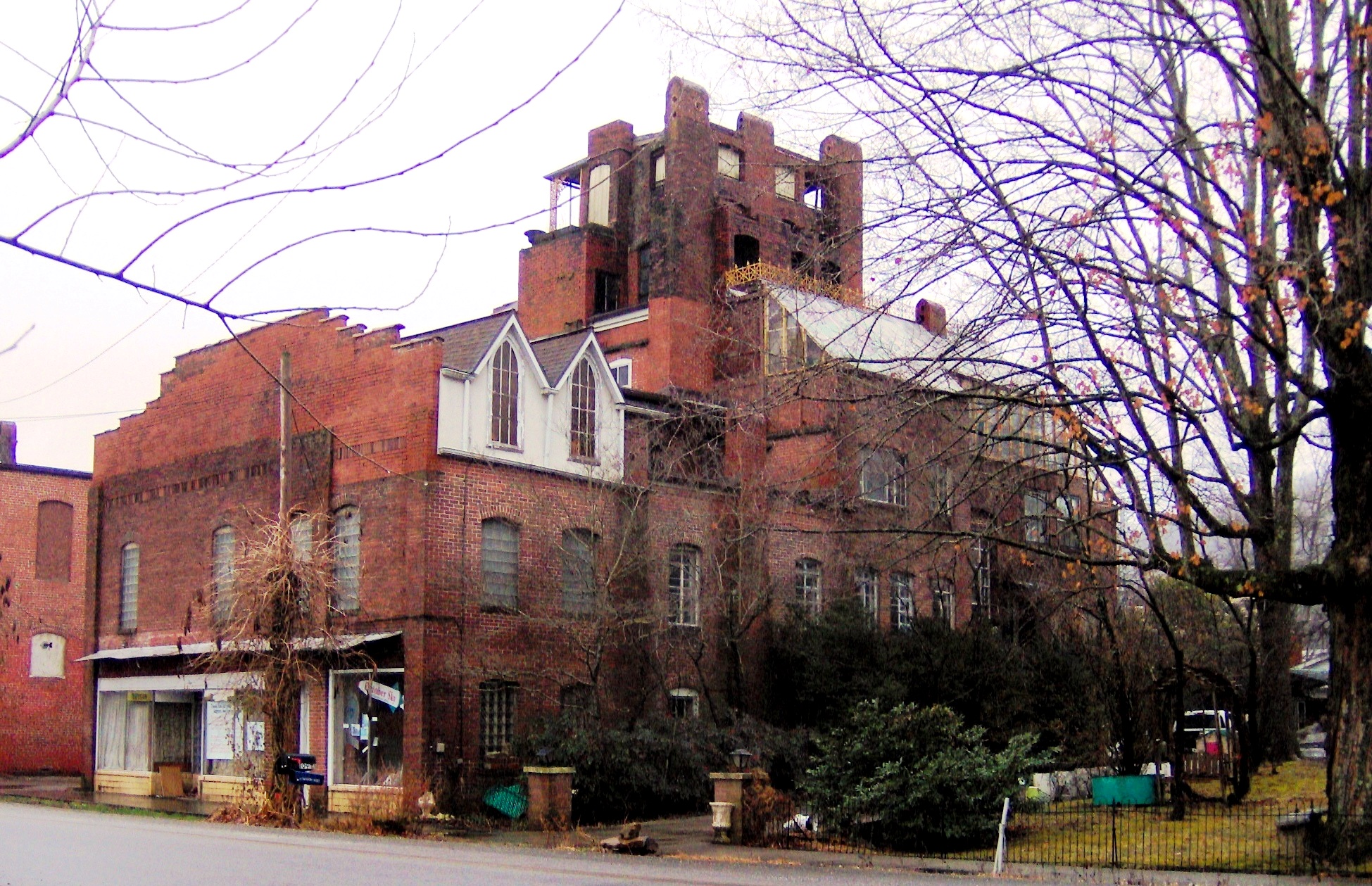
35°51′39″N 84°31′44″W / 35.860833°N 84.528889°WKingston Fort no longer standing; currently being reconstructed 17 Dr. Fred Stone, Sr. Hospital 
November 29, 2006 105 Roane St.
36°02′50″N 84°20′27″W / 36.047222°N 84.340833°WOliver Springs Unique building constructed piecemeal in various phases, many of which can be discerned from the exterior brickwork 18 Tennessee Highway Patrol Building 
March 14, 2001 Junction of Kingston Ave. and Nelson St.
35°51′36″N 84°40′52″W / 35.86°N 84.68111°W
Boundary increase (listed March 15, 2011): Nelson St and US 70 (Gateway)Rockwood Built of native crab orchard stone 19 Valley View Farm 
March 21, 1997 160 Martin Rd.
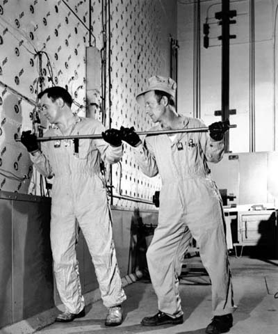
35°54′09″N 84°36′29″W / 35.9025°N 84.608056°WHarriman mid-19th century farmstead 20 X-10 Reactor, Oak Ridge National Laboratory 
October 15, 1966 Oak Ridge National Laboratory
35°55′41″N 84°19′03″W / 35.928056°N 84.3175°WOak Ridge See also
- List of National Historic Landmarks in Tennessee
- National Register of Historic Places listings in Tennessee
References
- ^ The latitude and longitude information provided in this table was derived originally from the National Register Information System, which has been found to be fairly accurate for about 99% of listings. For about 1% of NRIS original coordinates, experience has shown that one or both coordinates are typos or otherwise extremely far off; some corrections may have been made. A more subtle problem causes many locations to be off by up to 150 yards, depending on location in the country: most NRIS coordinates were derived from tracing out latitude and longitudes off of USGS topographical quadrant maps created under North American Datum of 1927, which differs from the current, highly accurate GPS system used by Google maps. Chicago is about right, but NRIS longitudes in Washington are higher by about 4.5 seconds, and are lower by about 2.0 seconds in Maine. Latitudes differ by about 1.0 second in Florida. Some locations in this table may have been corrected to current GPS standards.
- ^ "National Register of Historic Places: Weekly List Actions". National Park Service, United States Department of the Interior. Retrieved on November 10, 2011.
- ^ Numbers represent an ordering by significant words. Various colorings, defined here, differentiate National Historic Landmark sites and National Register of Historic Places Districts from other NRHP buildings, structures, sites or objects.
- ^ "National Register Information System". National Register of Historic Places. National Park Service. . http://nrhp.focus.nps.gov/natreg/docs/All_Data.html.
U.S. National Register of Historic Places Topics Lists by states Alabama • Alaska • Arizona • Arkansas • California • Colorado • Connecticut • Delaware • Florida • Georgia • Hawaii • Idaho • Illinois • Indiana • Iowa • Kansas • Kentucky • Louisiana • Maine • Maryland • Massachusetts • Michigan • Minnesota • Mississippi • Missouri • Montana • Nebraska • Nevada • New Hampshire • New Jersey • New Mexico • New York • North Carolina • North Dakota • Ohio • Oklahoma • Oregon • Pennsylvania • Rhode Island • South Carolina • South Dakota • Tennessee • Texas • Utah • Vermont • Virginia • Washington • West Virginia • Wisconsin • WyomingLists by territories Lists by associated states Other  Category:National Register of Historic Places •
  Portal:National Register of Historic Places
Municipalities and communities of Roane County, Tennessee County seat: Kingston Cities 
Town Unincorporated
communitiesFootnotes ‡This populated place also has portions in an adjacent county or counties
Categories:- National Register of Historic Places in Tennessee by county
- Roane County, Tennessee
- Buildings and structures in Roane County, Tennessee
-


Wikimedia Foundation. 2010.