- National Register of Historic Places listings in Putnam County, Tennessee
-
 Location of Putnam County in Tennessee
This is a list of the National Register of Historic Places listings in Putnam County, Tennessee.
This is intended to be a complete list of the properties and districts on the National Register of Historic Places in Putnam County, Tennessee, United States. Latitude and longitude coordinates are provided for many National Register properties and districts; these locations may be seen together in a Google map.[1]
There are 13 properties and districts listed on the National Register in the county.
Contents: Counties in Tennessee Anderson – Bedford – Benton – Bledsoe – Blount – Bradley – Campbell – Cannon – Carroll – Carter – Cheatham – Chester – Claiborne – Clay – Cocke – Coffee – Crockett – Cumberland – Davidson – Decatur – DeKalb – Dickson – Dyer – Fayette – Fentress – Franklin – Gibson – Giles – Grainger – Greene – Grundy – Hamblen – Hamilton – Hancock – Hardeman – Hardin – Hawkins – Haywood – Henderson – Henry – Hickman – Houston – Humphreys – Jackson – Jefferson – Johnson – Knox – Lake – Lauderdale – Lawrence – Lewis – Lincoln – Loudon – Macon – Madison – Marion – Marshall – Maury – McMinn – McNairy – Meigs – Monroe – Montgomery – Moore – Morgan – Obion – Overton – Perry – Pickett – Polk – Putnam – Rhea – Roane – Robertson – Rutherford – Scott – Sequatchie – Sevier – Shelby – Smith – Stewart – Sullivan – Sumner – Tipton – Trousdale – Unicoi – Union – Van Buren – Warren – Washington – Wayne – Weakley – White – Williamson – Wilson -
- This National Park Service list is complete through NPS recent listings posted November 10, 2011.[2]
Current listings
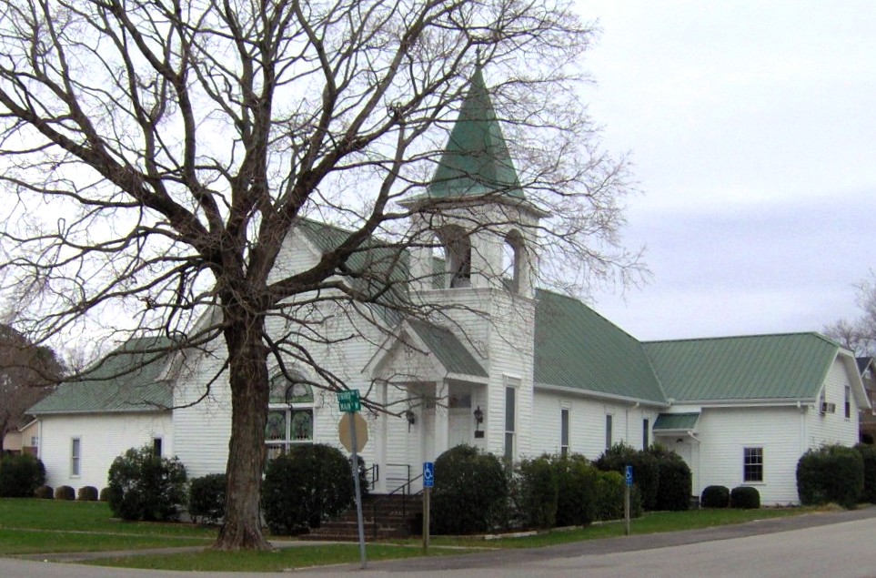
[3] Landmark name [4] Image Date listed Location City or town Summary 1 Algood Methodist Church 
November 15, 1979 158 Wall St.
36°11′37″N 85°26′57″W / 36.193611°N 85.449167°WAlgood 2 The Arcade 
April 17, 1979 7-13 S. Jefferson Ave.
36°09′45″N 85°30′01″W / 36.1625°N 85.500278°WCookeville Currently an office building 3 Broad Street Church of Christ 
February 1, 2002 157 E. Broad St.
36°09′48″N 85°30′57″W / 36.163333°N 85.515833°WCookeville Now a Methodist church known as "Wesley Chapel" 4 Buffalo Valley School 
July 5, 2006 2717 Buffalo Valley School Rd.
36°08′36″N 85°46′57″W / 36.143333°N 85.7825°WBuffalo Valley 5 Burgess Falls Hydroelectric Station 
July 5, 1990 State Route 135 over the Falling Water River
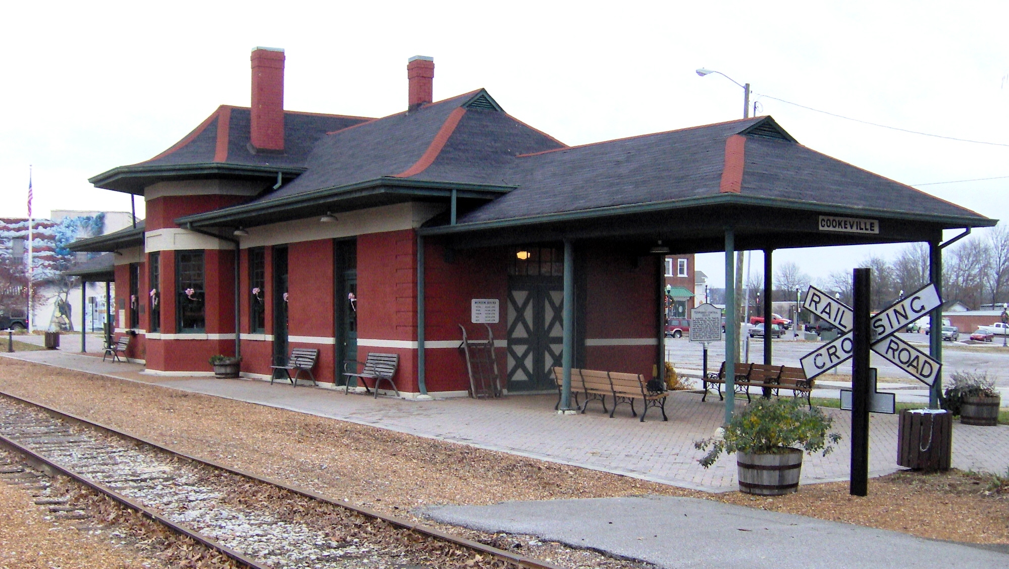
36°02′42″N 85°35′52″W / 36.045°N 85.597778°WCookeville Accessible from Burgess Falls State Park; TN-135 crosses the river just upstream from the dam 6 Cookeville Railroad Depot 
November 7, 1985 Broad and Cedar Sts.
36°09′51″N 85°30′30″W / 36.164167°N 85.508333°WCookeville Now a museum 7 Cowen Farmstead 
March 25, 2005 2671 Little Indian Creek Rd.
36°12′52″N 85°44′08″W / 36.214444°N 85.735556°WBuffalo Valley Now a red angus ranch known as Heritage Farms 8 First Presbyterian Church 
December 27, 2010 20 N. Dixie Ave.
36°09′48″N 85°30′08″W / 36.163333°N 85.502222°WCookeville Congregation founded in 1867, current church built in 1910 9 Harding Studio 
April 21, 1992 43 W. Broad St.
36°09′51″N 85°30′26″W / 36.164167°N 85.507222°WCookeville Used as a photography studio by the Harding family, 1914-1974 10 Henderson Hall 
November 7, 1985 Tennessee Technological University, Dixie Ave.
36°10′30″N 85°30′18″W / 36.175°N 85.505°WCookeville Houses Tennessee Tech's History and English department offices 11 John's Place 
March 15, 2011 11 Gibson Ave.
36°10′03″N 85°30′18″W / 36.1675°N 85.505°WCookeville Established in 1949 as a grocery store and restaurant for Cookeville's small African-American community; has been operated by the McClellan family since its establishment 12 West End Church of Christ Silver Point 
December 13, 2007 14360 Center Hill Dam Rd.
36°05′26″N 85°44′26″W / 36.090556°N 85.740556°WSilver Point Evolved from Silver Point Christian Institute, established in 1909 13 White Plains 
August 11, 2009 2700 Old Walton Rd.
36°10′39″N 85°27′01″W / 36.177636°N 85.450244°WCookeville See also
- List of National Historic Landmarks in Tennessee
- National Register of Historic Places listings in Tennessee
References
- ^ The latitude and longitude information provided in this table was derived originally from the National Register Information System, which has been found to be fairly accurate for about 99% of listings. For about 1% of NRIS original coordinates, experience has shown that one or both coordinates are typos or otherwise extremely far off; some corrections may have been made. A more subtle problem causes many locations to be off by up to 150 yards, depending on location in the country: most NRIS coordinates were derived from tracing out latitude and longitudes off of USGS topographical quadrant maps created under North American Datum of 1927, which differs from the current, highly accurate GPS system used by Google maps. Chicago is about right, but NRIS longitudes in Washington are higher by about 4.5 seconds, and are lower by about 2.0 seconds in Maine. Latitudes differ by about 1.0 second in Florida. Some locations in this table may have been corrected to current GPS standards.
- ^ "National Register of Historic Places: Weekly List Actions". National Park Service, United States Department of the Interior. Retrieved on November 10, 2011.
- ^ Numbers represent an ordering by significant words. Various colorings, defined here, differentiate National Historic Landmark sites and National Register of Historic Places Districts from other NRHP buildings, structures, sites or objects.
- ^ "National Register Information System". National Register of Historic Places. National Park Service. . http://nrhp.focus.nps.gov/natreg/docs/All_Data.html.
U.S. National Register of Historic Places Topics Lists by states Alabama • Alaska • Arizona • Arkansas • California • Colorado • Connecticut • Delaware • Florida • Georgia • Hawaii • Idaho • Illinois • Indiana • Iowa • Kansas • Kentucky • Louisiana • Maine • Maryland • Massachusetts • Michigan • Minnesota • Mississippi • Missouri • Montana • Nebraska • Nevada • New Hampshire • New Jersey • New Mexico • New York • North Carolina • North Dakota • Ohio • Oklahoma • Oregon • Pennsylvania • Rhode Island • South Carolina • South Dakota • Tennessee • Texas • Utah • Vermont • Virginia • Washington • West Virginia • Wisconsin • WyomingLists by territories Lists by associated states Other  Category:National Register of Historic Places •
  Portal:National Register of Historic Places
Municipalities and communities of Putnam County, Tennessee County seat: Cookeville City 
Towns Unincorporated
communitySilver Point
Categories:- National Register of Historic Places in Tennessee by county
- Putnam County, Tennessee
- Buildings and structures in Putnam County, Tennessee
-


Wikimedia Foundation. 2010.