- Ocoee Dam No. 1
-
Ocoee No. 1 Hydroelectric Station
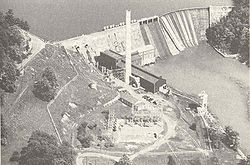
 Ocoee Dam No. 1, 1940s
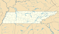
Location: Polk County, Tennessee Coordinates: 35°5′41″N 84°38′52″W / 35.09472°N 84.64778°WCoordinates: 35°5′41″N 84°38′52″W / 35.09472°N 84.64778°W Built: 1910-1911 Architect: J.G. White, W.P. Creager Governing body: Tennessee Valley Authority NRHP Reference#: 90001003 Added to NRHP: 1990 Ocoee Dam Number 1 is a hydroelectric dam on the Ocoee River in Polk County in the U.S. state of Tennessee. The dam impounds the 1,930-acre (780 ha) Parksville Reservoir (often called Ocoee Lake), and is the farthest downstream of four dams on the Toccoa/Ocoee River owned and operated by the Tennessee Valley Authority. Completed in 1911, Ocoee No. 1 was one of the first hydroelectric projects in Tennessee and remains the oldest dam in the TVA system.[1][2]
Contents
Location
Ocoee No. 1 is located approximately 12 miles (19 km) upstream from the mouth of the Ocoee, in an area where the river emerges from its winding trek through the Appalachian Mountains and enters the Tennessee Valley. The community of Parksville is located on the north side of the dam, and the city of Chattanooga is roughly 30 miles (48 km) to the west. The Ocoee Scenic Byway— part of U.S. Route 64— passes just north of the dam. Parksville Lake extends for several miles eastward up the Ocoee and several miles southward up Baker Creek, which once emptied into the Ocoee just upstream from the dam. Ocoee Dam No. 2 is located just over 12 miles (19 km) upstream from Ocoee No. 1.
Capacity
Ocoee No. 1 is 135 feet (41 m) high and 840 feet (260 m) long, and has a generating capacity of 24,000, up from an original 19,200 kilowatts after being refurbished in 1989-1991.[1] The dam's concrete gravity arched spillway has a maximum discharge of 45,000 cubic feet per second (1,300 m3/s).[2][3] Parksville Lake has 109 miles (175 km) of shoreline and the lake's water levels fluctuate by just 9 feet (2.7 m) per year.[1]
History
The rapid growth of industry in Chattanooga in the late 19th century and early 20th century brought an increasing demand for electricity, and the rapid-flowing Ocoee River— which slices through a gorge in the mountains 30 miles (48 km) east of the city— was considered a prime candidate for hydroelectric power by the region's early electric companies. In 1910, the C.M. Clark Company, an electrical transportation holding firm, formed the Eastern Tennessee Power Company to build two hydroelectric dams on the Ocoee, and market their electricity output primarily to Chattanooga. Work on Ocoee Dam No. 1 began later that year, and was completed in late December 1911. By January 27, 1912, electricity from Ocoee Dam No. 1 was flowing into Chattanooga.[4]
In 1922, the Eastern Tennessee Power Company and several other entities merged to form the Tennessee Electric Power Company (TEPCO), which overhauled Ocoee No. 1 in the 1930s.[3][5] In 1933, the TVA Act created the Tennessee Valley Authority and gave the Authority oversight of the Tennessee River watershed, which includes the Ocoee River. The head of TEPCO, Jo Conn Guild, was vehemently opposed to the creation of TVA, and with the help of attorney Wendell Wilkie, challenged the constitutionality of the TVA Act in federal court. The U.S. Supreme Court upheld the TVA Act, however, in its 1939 decision Tennessee Electric Power Company v. TVA. On August 16, 1939, TEPCO was forced to sell its assets to TVA for $78 million, which included $2.68 million for Ocoee Dam No. 1.[3][6]
References
- ^ a b c Tennessee Valley Authority, Parksville Reservoir. Retrieved: 21 January 2009.
- ^ a b Tennessee Valley Authority, The Nickajack Project: A Report on the Planning, Design, Construction, Initial Operations, and Costs, Technical Report No. 16 (Knoxville, Tenn.: Tennessee Valley Authority, 1972), pp. 10-11.
- ^ a b c Tennessee Valley Authority, Design of TVA Projects Volume 3: Mechanical Design of Hydro Plants, Technical Report No. 24 (Washington, D.C.: Tennessee Valley Authority, 1952), pp. 302-304.
- ^ James B. Jones, Jr. Towards an Understanding of the History and Material Culture of Pre-TVA Hydroelectric Development in Tennessee, 1900-1933. Retrieved: 22 January 2009. PDF.
- ^ James B. Jones, "TEPCO. Tennessee Encyclopedia of History and Culture, 2002. Retrieved: 21 January 2009.
- ^ Timothy Ezzell, "Jo Conn Guild." Tennessee Encyclopedia of History and Culture, 2002. Retrieved: 22 January 2009.
External links
- Parksville Reservoir — official TVA site
Facilities operated by the Tennessee Valley Authority Dams and hydroelectric
generating stationsApalachia · Bear Creek · Beaver Creek · Beech · Blue Ridge · Boone · Cedar · Cedar Creek · Chatuge · Cherokee · Chickamauga · Clear Creek · Dogwood · Douglas · Fontana · Fort Loudoun · Fort Patrick Henry · Great Falls · Guntersville · Hiwassee · Kentucky · Little Bear Creek · Lost Creek · Melton Hill · Nickajack · Nolichucky · Normandy · Norris · Nottely · Ocoee 1 · Ocoee 2 · Ocoee 3 · Pickwick Landing · Pin Oak · Pine · Raccoon Mountain · Redbud · South Holston · Sycamore · Tellico · Tims Ford · Upper Bear Creek · Watauga · Watts Bar · Wheeler · Wilbur · Wilson
Coal-fired power plants Allen · Bull Run · Colbert · Cumberland · Gallatin · John Sevier · Johnsonville · Kingston · Paradise · Shawnee · Widows CreekCombustion turbine plants Caledonia · Gleason · Kemper · Lagoon Creek · MarshallNuclear power plants Categories:- Historic districts in Tennessee
- Tennessee Valley Authority
- Buildings and structures in Polk County, Tennessee
- Dams in Tennessee
- Hydroelectric power plants in Tennessee
- National Register of Historic Places in Tennessee
Wikimedia Foundation. 2010.

