- Ocoee Whitewater Center
-
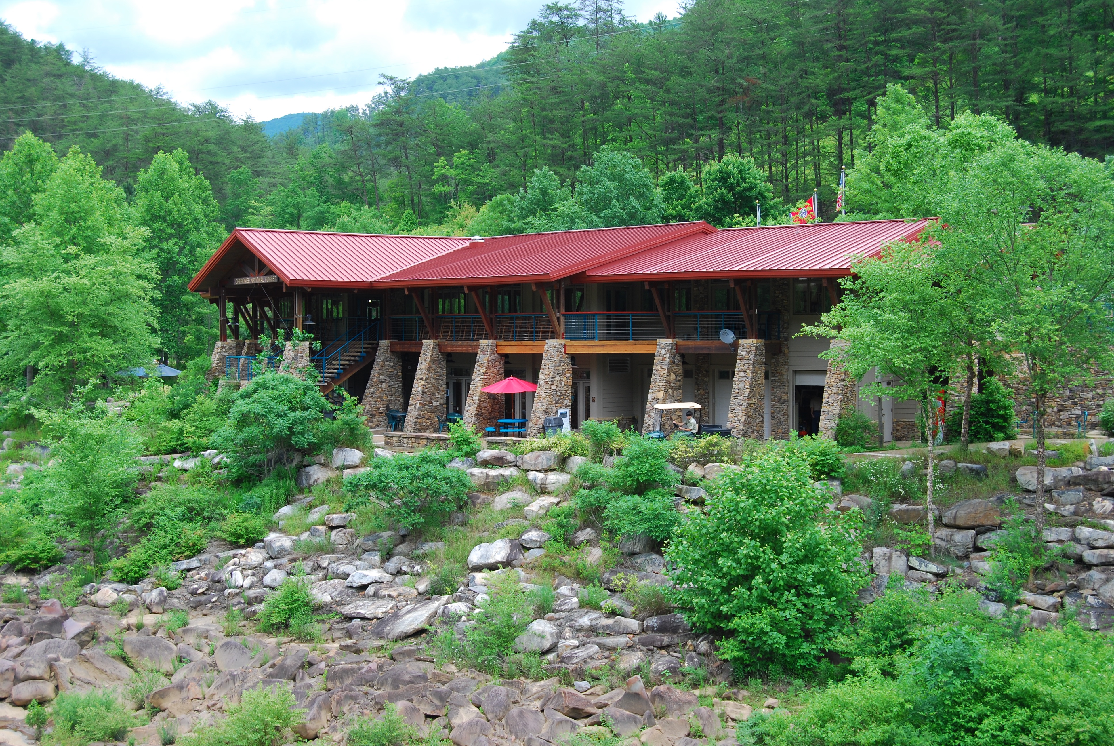
 Visitor Center
The Ocoee Whitewater Center, near Ducktown, Tennessee, United States, was the canoe slalom venue for the 1996 Summer Olympics in Atlanta.[1][2] The Olympic race course was built in the dry riverbed of the Upper Ocoee river. The Upper Ocoee is the 3.5 mi (5.6 km) section between Ocoee Dam #3 and its downstream powerhouse. The Middle Ocoee is the 4.5 mi (7.2 km) section between Ocoee Dam #2 and its downstream powerhouse. The same river in Georgia, upstream of the lake behind Dam #3, is called the Tocoa River. The river was narrowed by two-thirds, and natural boulders were moved and cemented into place to create the drops and eddies needed for a slalom course. It is the only in-river course to be used for Olympic slalom competition. A visitor center, parking lot, and suspension foot bridge were part of the Olympic construction project.
Today, the course is watered only on summer weekends, for use by guided rafts and private boaters. The hanging slalom gates have been permanently removed. Because the river rarely has water, the Center, now operated by the U.S. Forest Service, serves primarily as a site for hiking, mountain biking, conferences, weddings, and receptions. It receives about 300,000 visitors a year.[3]
Contents
Olympic slalom course
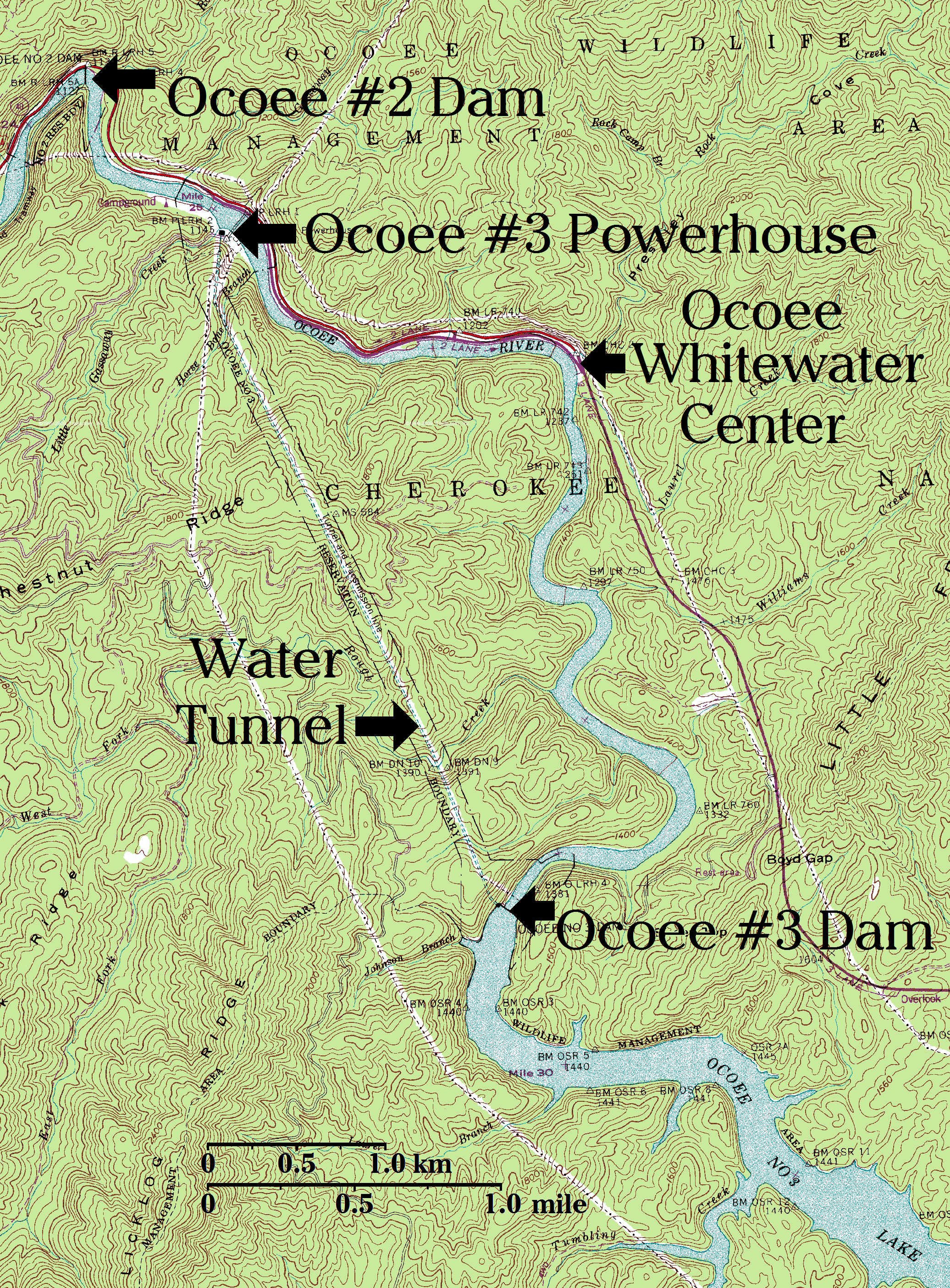
River flow through the Ocoee Whitewater Center is controlled by Ocoee Dam #3, two miles (3 km) upstream. Its hydroelectric power plant is located downstream from the Center, fed by a tunnel and penstock which carry all the water used for power generation, bypassing the section of river where the Whitewater Center is located. Consequently, all water for the Olympic course must be released directly into the river from Dam #3, bypassing the tunnel and penstock and forfeiting the production of 30 Megawatts of electricity. This makes the Ocoee Olympic course the world's most expensive to operate, and is the chief reason it is no longer used for slalom training and competition. Only the commercial rafting industry can afford the water.
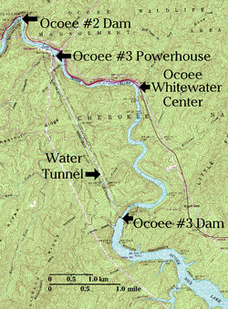 Upper Ocoee River Topographical Map.
For 54 years, from 1942, when the dam was built by the Tennessee Valley Authority, until 1996, when the Olympic Games came to Atlanta, the Upper Ocoee, a 3.5 mi (5.6 km) section of Ocoee riverbed between Dam #3 and its powerhouse, was dewatered except during flood control releases, usually during the winter and spring. For twenty years, 1976-1996, whitewater rafting on the Middle Ocoee just downstream, between Dam #2 and its powerhouse, had attracted attention to the area. The availability of the Upper Ocoee as a dry construction site during the summer greatly aided the creation of an Olympic slalom course in the riverbed.
A 1-to-10 scale model of the riverbed, with water, was constructed outdoors near the base of Ocoee Dam #1 to test the effect of the proposed course design. The 1.9% slope of the river (99 ft/mile, 19 meters/km) is typical of Olympic courses, but, because the narrowed river is still much wider than a typical artificial slalom channel, the required streamflow (1560 cubic feet/second, 44 m³/s) is two to three times greater than usual.
Construction of the course was a pivotal event in the history of Olympic whitewater. The first Olympic whitewater competition took place during the 1972 Olympic Games in Munich, using the world's first artificial slalom course, the Eiskanal in nearby Augsburg, as the venue. Because of the expense of course construction, the next four Summer Olympic Games were held without whitewater events. In 1992, for the Barcelona games, an artificial slalom course, Parc Olímpic del Segre, was constructed in the nearby Pyrenees mountains, using natural streamflow supplemented by pump-driven recirculation.
After 1992, because of construction expense, the future of Olympic whitewater events was once again in question. Had they not been included in the 1996 Atlanta Olympics, they might have been dropped forever, but Ocoee established whitewater as a permanent feature of the summer Olympics. Every host city since 1996 has built a whitewater stadium powered entirely by electric pumps (which consume electricity at the rate of about 3 Megawatts, one tenth the electricity cost of the Ocoee course).
The Whitewater Center today
Whitewater rafting on the Middle Ocoee, downstream from the Whitewater Center, first became a thriving industry in 1976, when the wooden flume between Dam #2 and its powerhouse was shut down for renovation. The power generation system for Dam #2 is similar to that for Dam #3. In both cases water is drained from the lake behind the dam and transported with little loss in elevation to a penstock and powerhouse several miles downstream. From Dam #2 the water travels through an above-ground wooden aqueduct, or flume, rather than through a tunnel. In both cases, the riverbed between the dam and powerhouse, which drops about 250 feet (76 m) in elevation, is deprived of all the water used in power generation.
From 1913, when Dam #2 and its flume were completed, until 1976, when the flume was shut down for repair, the 4.5-mile (7.2 km) section of river below the flume was dewatered most of the time, especially in summer. In 1976, the sudden appearance of water in the long-dry Middle Ocoee river attracted private canoers and kayakers and commercial rafting operators, who by 1983, when the flume was put back in service, had enough political clout and money to strike a deal with TVA for regular recreational releases during the summer months. Thirteen years later, when the 1996 Olympic Games came to the Upper Ocoee, recreational releases were scheduled for the upper section of the river as well.
According to a 13-year agreement now in force, the Upper Ocoee, below Dam #3 and flowing past the Whitewater Center, has mid-day water 34 days a year, on summer weekends.[4] The Middle Ocoee, below Dam #2, has water 106 days a year. On the days when the Upper Ocoee is also watered, the Middle Ocoee has water into the early evening (its own release plus the extra water from upstream).[5] Most rafting activity takes place on the Middle Ocoee, which has a 1% slope of 50 ft/mile (9.5 m/km). Rafting down the Upper Ocoee, and through the steeper Olympic course, is offered as a more challenging alternative.
Hiking, Biking, and Camping
The Tanasi Trail System Mountain Bike Trail offers 30 miles (48 km) of trails centered on the Whitewater Center. The Thunder Rock Campground is located at Powerhouse #3, one mile (1.6 km) west (downstream) of the Center. The Ocoee Scenic Byway provides access to the center and is usually open year-round.
References
Coordinates: 35°04′08″N 84°27′43″W / 35.069°N 84.462°W
Venues of the 1996 Summer Olympics Olympic Ring Alexander Memorial Coliseum · Atlanta-Fulton County Stadium · Clark Atlanta University Stadium · Cycling road course · Georgia Dome · Georgia State University Gymnasium · Georgia Tech Aquatic Center · Georgia World Congress Center · Marathon course · Morehouse College Gymnasium · Morris Brown College Stadium · Olympic Stadium · Omni Coliseum · Walking courseMetro Atlanta Other venues Florida Citrus Bowl (Orlando, Florida) · Golden Park (Columbus, Georgia) · Legion Field (Birmingham, Alabama) · Ocoee Whitewater Center (Polk County, Tennessee) · Orange Bowl (Miami, Florida) · RFK Memorial Stadium (Washington, D.C.) · Sanford Stadium (Athens, Georgia) · University of Georgia Coliseum (Athens, Georgia) · Wassaw Sound (Savannah, Georgia)1936: Grünau Regatta Course • 1948: Henley Royal Regatta • 1952: Taivallahti • 1956: Lake Wendouree • 1960: Lake Albano • 1964: Lake Sagami • 1968: Virgilio Uribe Rowing and Canoeing Course • 1972: Eiskanal, Regattastrecke Oberschleißheim • 1976: Île Notre-Dame • 1980: Krylatskoye Sports Complex Canoeing and Rowing Basin • 1984: Lake Casitas • 1988: Han River Regatta Course/Canoeing Site • 1992: Canal Olímpic de Catalunya, Parc Olímpic del Segre • 1996: Lake Lanier, Ocoee Whitewater Center • 2000: Penrith Whitewater Stadium, Sydney International Regatta Centre • 2004: Olympic Canoe/Kayak Slalom Centre, Schinias Olympic Rowing and Canoeing Centre • 2008: Shunyi Olympic Rowing-Canoeing Park • 2012: Dorney Lake, Lee Valley White Water Centre • 2016: Lagoa Rodrigo de Freitas, Olympic Whitewater Stadium Categories:
- 1996 Summer Olympic venues
- Artificial whitewater courses
- Olympic canoeing venues
- Sports venues in Tennessee
- Buildings and structures in Polk County, Tennessee
- Visitor attractions in Polk County, Tennessee

Wikimedia Foundation. 2010.