- Nantahala Outdoor Center
-
 Nantahala Outdoor Center
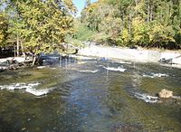
The Nantahala Outdoor Center (NOC) is a commercial outdoor guide service and retail store. It opened in 1972 when Payson and Aurelia Kennedy and Horace Holden Sr. took over the old Tote 'N Tarry Motel. NOC is based in western North Carolina near Bryson City, near the Great Smoky Mountains on the Nantahala River. NOC is surrounded by Nantahala National Forest. The Appalachian Trail passes directly through the heart of the NOC, crossing the Nantahala River on a bridge next to the outfitter.[1]
NOC operates whitewater rafting trips on seven Southeastern rivers: the Chattooga[2], Cheoah, French Broad, Nantahala, Nolichucky, Ocoee, and Pigeon.
The NOC also teaches people to paddle in its canoe and kayak paddling school.[3] They also offer mountain bike rentals, group programs, outdoor retail, restaurants, ropes courses, kayak touring, fly fishing and hiking.[4]
Former NOC president John Burton (who, until recently, was an owner/operator of nearby Nantahala Village Resort) was a member of the original 1972 Olympic slalom team. His teammate Angus Morrison, currently a head guide for Nantahala River Guided Trips, was also on the Olympic team that year, as well as in 1976 and 1980. More recently, Olympians Lecky and Fritz Haller, Horace Holden, Jr., Wayne Dickert (currently head of NOC Instruction), Joe Jacobi, Scott Strausbaugh and Scott Shipley have all trained with the Nantahala Racing Club at NOC on the Nantahala River.[5] Jacobi and Strausbaugh, paddling C-2, are the only Americans ever to have won an Olympic gold medal for the US in whitewater, which they did in Barcelona in 1992.[6]
References
- ^ Wilbert, Carolina. http://money.cnn.com/magazines/fsb/fsb_archive/2004/06/01/373302/index.htm "Rapid Transit: The Nantahala Outdoor Center teaches novice kayakers at the facility where whitewater Olympians train"], Fortune Small Business, June 1, 2004.
- ^ "Finding Your Way to the Whitewater", New York Times, October 27, 2007.
- ^ Hurt III, Harry. "Tucking Forward, Chilling Out and Waiting for ‘the Hands of God’", New York Times, Travel section, July 28, 2007.
- ^ Wilbert, Carolina. http://money.cnn.com/magazines/fsb/fsb_archive/2004/06/01/373302/index.htm "Rapid Transit: The Nantahala Outdoor Center teaches novice kayakers at the facility where whitewater Olympians train"], Fortune Small Business, June 1, 2004.
- ^ Wilbert, Carolina. http://money.cnn.com/magazines/fsb/fsb_archive/2004/06/01/373302/index.htm "Rapid Transit: The Nantahala Outdoor Center teaches novice kayakers at the facility where whitewater Olympians train"], Fortune Small Business, June 1, 2004.
- ^ [http://www.nytimes.com/1992/08/03/sports/barcelona-roundup-us-paddling-pair-makes-a-golden-splash.html "Barcelona: Roundup; U.S. Paddling Pair Makes a Golden Splash, New York Times, Sports section, August 3, 1992.
External links
- www.noc.com - Official website
- Official website of the Nantahala Racing Club
Categories:- Buildings and structures in Swain County, North Carolina
- North Carolina outdoor recreation
- Visitor attractions in Swain County, North Carolina
- Companies based in North Carolina

Wikimedia Foundation. 2010.