The Northern Forest Canoe Trail (NFCT) is a 740-mile (1,190 km) marked canoeing trail in the northeastern United States and Canada, extending from Old Forge in the Adirondacks of New York to Fort Kent in Maine. Along the way, the trail also passes through the states and provinces of Vermont, Quebec, and New Hampshire. The trail was opened on June 3, 2006.
The trail
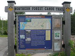
Northern Forest Canoe Trail (NFCT) sign
The trail has been likened to a water version of the Appalachian Trail, and there are many similarities: both are long-distance trails that most people will use for day trips or short overnight trips; many of those who paddle the entire trail will do so in sections. Unlike the AT, the NFCT obtains access for campsites and portages through landowner permission rather than through land protection. Also, many sections of the trail require a high level of skill to complete.[1]
The trail is divided into 13 sections: Adirondack Country (West) New York, Adirondack North Country (Central) New York, Adirondack Country (East) New York, Islands and Farms Region Vermont, Upper Missisquoi Valley Vermont/Quebec, Northeast Kingdom Quebec/Vermont, Great North Woods New Hampshire, Rangeley Lakes Region Maine, Flagstaff Region Maine, Greater Jackman Region Maine, Moosehead/Penobscot Region Maine, Allagash Region (South) Maine, and Allagash Region (North) Maine. Each of these sections has been mapped and documented in order to establish the trail. Trail towns include Old Forge and Saranac Lake in New York, and Rangeley, Maine.
The trail covers 56 lakes and ponds, 22 rivers and streams, and 62 "carries" (portages) totaling 55 miles (89 km). On some sections of the trail, portage trails, campsites, and access areas are marked with Northern Forest Canoe Trail medallions, a yellow diamond with blue lettering.
The American Canoe Association has named the NFCT an ACA-Recommended Water Trail.
The route, by state
New York
147 miles (237 km). Starting at Old Forge, the route follows the Moose River through the Fulton Chain Lakes, to Raquette Lake, thence via the Raquette River to Forked Lake, Long Lake and finally via the Stoney Creek Ponds and the Indian Carry to Upper Saranac Lake. The route proceeds via Bartletts Carry to Middle Saranac Lake, Lower Saranac Lake, Lake Flower, then via the Saranac River to Franklin Falls Pond, Union Falls Pond, and finally Lake Champlain. The route is primarily scenic flatwater, following the long-established "Highway of the Adirondacks." The Saranac River is a scenic, sometimes challenging, route off of the Adirondack Plateau.
Vermont/Quebec
174 miles (280 km). Lake Champlain is the most historic lake in America, and very big. The Missisquoi River is mostly slow water through a pastoral landscape, with a few rapids and several carries, including Québec’s historic "Grand Portage" to Lake Memphremagog. The Clyde and Nulhegan rivers each flow through sections of wetlands, ponds, and rapids, and include several carries as they flow through the Northeast Kingdom of Vermont.
New Hampshire
72 miles (116 km). The Connecticut is placid as it meanders to the Upper Ammonoosuc. The Upper Ammonoosuc is quickwater with a few rapids. The Androscoggin flows out of Umbagog Lake, with stretches of slowly flowing water punctuated by some rapids, and a wide, quiet reservoir with relics of logging days visible on the banks.
Maine
347 miles (558 km). The trail starts at the Rangeley Lakes. The steep Rapid River is portaged. The seasonal flow of the South Branch Dead River has a couple of rapid sections as it flows into the wide, scenic Flagstaff Lake. Grand Falls is a spectacular highlight at the confluence of the Dead River and Spencer Stream. The Spencer and Little Spencer watershed is remote, as is the beginning of the Moose River. The Moose flows through many lakes and some rapids on its way to the broad, storied stretches of Moosehead Lake. The West Branch Penobscot River provides a connection between Moosehead and the large lakes that form the headwaters of the Allagash River. The Allagash Wilderness Waterway is a ribbon of lakes, ponds, rivers and occasional rapids winding through northern Maine to the wide St. John River on the Canadian border.
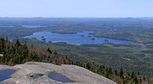
Spencer Pond and Moosehead Lake, Maine, from Little Spencer Mountain
Through-paddlers
As of 2010[update], 27 people have "through-paddled" the trail — traveling the length of the trail in one expedition. In addition, two others have completed it in multiple trips.[2]
Nicole Grohoski and Thomas Perkins of Ellsworth, Maine were the first to officially through-paddle the trail in 2006, traveling the length of the trail in about 45 days. Donnie Mullen paddled the trail in 2000 before its official opening, taking about 55 days but doing so without the signs and maps that are available today. The fastest thru-paddle was completed in 2007 by Alexander Bailey Martin and Benjamin Reilly; the trip took them 32 days.
Northern Forest Canoe Trail literature
References
External links
Coordinates: 44°47.5′N 71°2.5′W / 44.7917°N 71.0417°W / 44.7917; -71.0417 (Northern Forest Canoe Trail)
43°42′45″N 74°58′10″W / 43.71260°N 74.96945°W / 43.71260; -74.96945 (Old Forge, New York) 43°45′03″N 74°47′41″W / 43.75075°N 74.79485°W / 43.75075; -74.79485 (Inlet, New York) 43°48′38″N 74°39′25″W / 43.81065°N 74.65695°W / 43.81065; -74.65695 (Raquette Lake, New York) 43°53′11″N 74°35′09″W / 43.88645°N 74.58575°W / 43.88645; -74.58575 (Woods, New York) 43°55′30″N 74°28′40″W / 43.92500°N 74.47790°W / 43.92500; -74.47790 (Long Lake (SW)) 43°58′28″N 74°25′34″W / 43.97455°N 74.42605°W / 43.97455; -74.42605 (Long Lake, New York) 44°05′14″N 74°19′03″W / 44.08720°N 74.31750°W / 44.08720; -74.31750 (Long Lake (NE)) 44°11′58″N 74°19′08″W / 44.19945°N 74.31890°W / 44.19945; -74.31890 (Raquette River) 44°13′47″N 74°18′55″W / 44.22975°N 74.31520°W / 44.22975; -74.31520 (Indian Carry)
44°15′11″N 74°17′36″W / 44.25315°N 74.29340°W / 44.25315; -74.29340 (Bartlett Carry) 44°17′19″N 74°11′02″W / 44.28855°N 74.18390°W / 44.28855; -74.18390 (Lower Saranac Lake) 44°19′28″N 74°07′55″W / 44.32435°N 74.13200°W / 44.32435; -74.13200 (Saranac Lake, New York) 44°23′51″N 74°04′23″W / 44.39760°N 74.07305°W / 44.39760; -74.07305 (Saranac River) 44°26′15″N 73°58′20″W / 44.43760°N 73.97220°W / 44.43760; -73.97220 (Franklin Falls, New York) 44°30′28″N 73°54′54″W / 44.50765°N 73.91500°W / 44.50765; -73.91500 (Union Falls, New York) 44°35′46″N 73°50′15″W / 44.59600°N 73.83760°W / 44.59600; -73.83760 (Clayburg, New York) 44°37′40″N 73°45′37″W / 44.62780°N 73.76030°W / 44.62780; -73.76030 (Saranac, New York dam) 44°41′14″N 73°40′01″W / 44.68730°N 73.66705°W / 44.68730; -73.66705 (Elsinore, New York) 44°41′59″N 73°26′51″W / 44.69960°N 73.44740°W / 44.69960; -73.44740 (Plattsburgh, New York)
44°45′56″N 73°17′21″W / 44.76550°N 73.28930°W / 44.76550; -73.28930 (Lake Champlain) 45°00′19″N 73°09′36″W / 45.00530°N 73.16000°W / 45.00530; -73.16000 (Missiquoi Bay) 44°56′03″N 73°02′52″W / 44.93420°N 73.04770°W / 44.93420; -73.04770 (Highgate Falls, Vermont) 44°54′06″N 72°57′05″W / 44.90170°N 72.95150°W / 44.90170; -72.95150 (Sheldon Junction, Vermont) 44°54′06″N 72°48′28″W / 44.90180°N 72.80770°W / 44.90180; -72.80770 (Enosburg Falls, Vermont) 44°59′48″N 72°40′19″W / 44.99670°N 72.67200°W / 44.99670; -72.67200 (Richford, Vermont) 45°00′43″N 72°35′17″W / 45.01200°N 72.58800°W / 45.01200; -72.58800 (U.S.–Canada border)
45°01′37″N 72°25′48″W / 45.02690°N 72.42990°W / 45.02690; -72.42990 (Highwater, Québec) 45°04′22″N 72°23′14″W / 45.07280°N 72.38725°W / 45.07280; -72.38725 (Potton, Québec) 45°05′30″N 72°17′41″W / 45.09180°N 72.29470°W / 45.09180; -72.29470 (Perkins Landing, Québec)
44°56′16″N 72°12′20″W / 44.93790°N 72.20550°W / 44.93790; -72.20550 (Newport, Vermont) 44°56′01″N 72°10′38″W / 44.93360°N 72.17710°W / 44.93360; -72.17710 (Lake Clyde dam) 44°56′11″N 72°07′08″W / 44.93630°N 72.11900°W / 44.93630; -72.11900 (Lake Salem (NW)) 44°53′57″N 72°03′36″W / 44.89930°N 72.06000°W / 44.89930; -72.06000 (West Charleston, Vermont) 44°50′14″N 71°59′26″W / 44.83730°N 71.99050°W / 44.83730; -71.99050 (East Charleston, Vermont) 44°48′47″N 71°52′52″W / 44.81300°N 71.88110°W / 44.81300; -71.88110 (Island Pond, Vermont) 44°47′47″N 71°50′22″W / 44.79633°N 71.83935°W / 44.79633; -71.83935 (Brighton State Park) 44°46′17″N 71°44′31″W / 44.77140°N 71.74200°W / 44.77140; -71.74200 (Wenlock, Vermont) 44°45′05″N 71°38′01″W / 44.75140°N 71.63350°W / 44.75140; -71.63350 (Bloomfield, Vermont)
44°39′07″N 71°33′44″W / 44.65200°N 71.56235°W / 44.65200; -71.56235 (Stratford, New Hampshire) 44°35′20″N 71°32′05″W / 44.58900°N 71.53480°W / 44.58900; -71.53480 (Groveton, New Hampshire) 44°37′15″N 71°23′00″W / 44.62070°N 71.38321°W / 44.62070; -71.38321 (Percy, New Hampshire) 44°35′41″N 71°18′05″W / 44.59460°N 71.30130°W / 44.59460; -71.30130 (West Milan, New Hampshire) 44°36′55″N 71°14′07″W / 44.61520°N 71.23520°W / 44.61520; -71.23520 (Androscoggin River) 44°42′53″N 71°10′25″W / 44.71460°N 71.17350°W / 44.71460; -71.17350 (Minsfield Pond Road) 44°46′42″N 71°07′54″W / 44.77820°N 71.13180°W / 44.77820; -71.13180 (Errol, New Hampshire)
44°47′10″N 70°59′10″W / 44.78600°N 70.98600°W / 44.78600; -70.98600 (Rapid River) 44°46′36″N 70°55′12″W / 44.77660°N 70.91990°W / 44.77660; -70.91990 (Lower Richardson Lake) 44°52′41″N 70°52′05″W / 44.87800°N 70.86800°W / 44.87800; -70.86800 (Upper Richardson Lake) 44°57′42″N 70°47′43″W / 44.96180°N 70.79530°W / 44.96180; -70.79530 (Mooselookmeguntic, Maine) 44°57′54″N 70°46′05″W / 44.96490°N 70.76800°W / 44.96490; -70.76800 (Oquossoc, Maine) 44°57′55″N 70°38′47″W / 44.96540°N 70.64640°W / 44.96540; -70.64640 (Rangeley, Maine)
45°00′16″N 70°34′34″W / 45.00440°N 70.57600°W / 45.00440; -70.57600 (Dallas, Maine) 45°04′00″N 70°34′35″W / 45.06680°N 70.57640°W / 45.06680; -70.57640 (Langtown Mill, Maine) 45°09′08″N 70°26′47″W / 45.15220°N 70.44650°W / 45.15220; -70.44650 (Stratton, Maine) 45°13′19″N 70°12′07″W / 45.22200°N 70.20200°W / 45.22200; -70.20200 (Flagstaff Lake, Maine) 45°17′49″N 70°13′18″W / 45.29700°N 70.22180°W / 45.29700; -70.22180 (Grand Falls) 45°25′52″N 70°17′31″W / 45.43100°N 70.29190°W / 45.43100; -70.29190 (Spencer Lake) 45°29′42″N 70°17′18″W / 45.49500°N 70.28840°W / 45.49500; -70.28840 (Whipple Pond)
45°31′13″N 70°17′45″W / 45.52030°N 70.29580°W / 45.52030; -70.29580 (Spencer Rips) 45°38′12″N 70°15′44″W / 45.63660°N 70.26220°W / 45.63660; -70.26220 (Jackman, Maine) 45°37′04″N 69°58′03″W / 45.61790°N 69.96740°W / 45.61790; -69.96740 (Demo Road) 45°38′03″N 69°55′30″W / 45.63410°N 69.92500°W / 45.63410; -69.92500 (Little Brassua Lake) 45°40′56″N 69°45′55″W / 45.68220°N 69.76530°W / 45.68220; -69.76530 (Rockwood, Maine) 45°50′46″N 69°41′17″W / 45.84600°N 69.68800°W / 45.84600; -69.68800 (Moosehead Lake) 45°53′39″N 69°36′37″W / 45.89430°N 69.61030°W / 45.89430; -69.61030 (Northeast Carry) 45°59′26″N 69°31′24″W / 45.99060°N 69.52330°W / 45.99060; -69.52330 (Smith Halfway House) 46°04′12″N 69°25′10″W / 46.07000°N 69.41950°W / 46.07000; -69.41950 (Chesuncook Lake)
46°18′55″N 69°22′44″W / 46.31520°N 69.37890°W / 46.31520; -69.37890 (Chamberlain Lake)
46°29′34″N 69°17′17″W / 46.49270°N 69.28800°W / 46.49270; -69.28800 (Churchill Depot, Maine) 46°36′53″N 69°23′33″W / 46.61480°N 69.39240°W / 46.61480; -69.39240 (The Thoroughfare) 46°45′47″N 69°18′19″W / 46.76310°N 69.30530°W / 46.76310; -69.30530 (Henderson Brook) 46°57′05″N 69°11′41″W / 46.95150°N 69.19460°W / 46.95150; -69.19460 (Michaud Farm) 47°05′00″N 69°02′44″W / 47.08320°N 69.04560°W / 47.08320; -69.04560 (Allagash, Maine) 47°10′27″N 68°53′56″W / 47.17430°N 68.89880°W / 47.17430; -68.89880 (St. Francis, Maine) 47°13′30″N 68°45′07″W / 47.22500°N 68.75200°W / 47.22500; -68.75200 (Wheelock, Maine) 47°15′14″N 68°35′46″W / 47.25400°N 68.59600°W / 47.25400; -68.59600 (Fort Kent, Maine)
| v · d · eCanoeing and kayaking |
|
| Main sports |
|
|
| Olympics |
|
|
| Other sports |
|
|
International
Canoe Federation |
World Championships - Sprint (Men's Canadian medalists, Women's Canadian medalists, Men's kayak medalists, Women's kayak medalists, Paracanoe medalists), Slalom
|
|
| Recreation |
|
|
| Modern boat types |
|
|
| Traditional boat types |
|
|
| Terms |
|
|
| Equipment |
|
|
Meteorology
& sea states |
|
|
| Kayakers |
|
|
Venues
(Rivers and
Artificial courses) |
|
Asia
|
|
|
|
Australia
|
|
|
|
Europe
|
|
|
|
North America
|
|
|
|
Lists of venues
|
|
|
|
| Competitions |
|
|
Suppliers &
manufacturers |
|
|
National
governing bodies |
|
|
| Notable clubs |
|
|
Other canoe/
kayak organisations |
|
|
| In the arts |
|
|

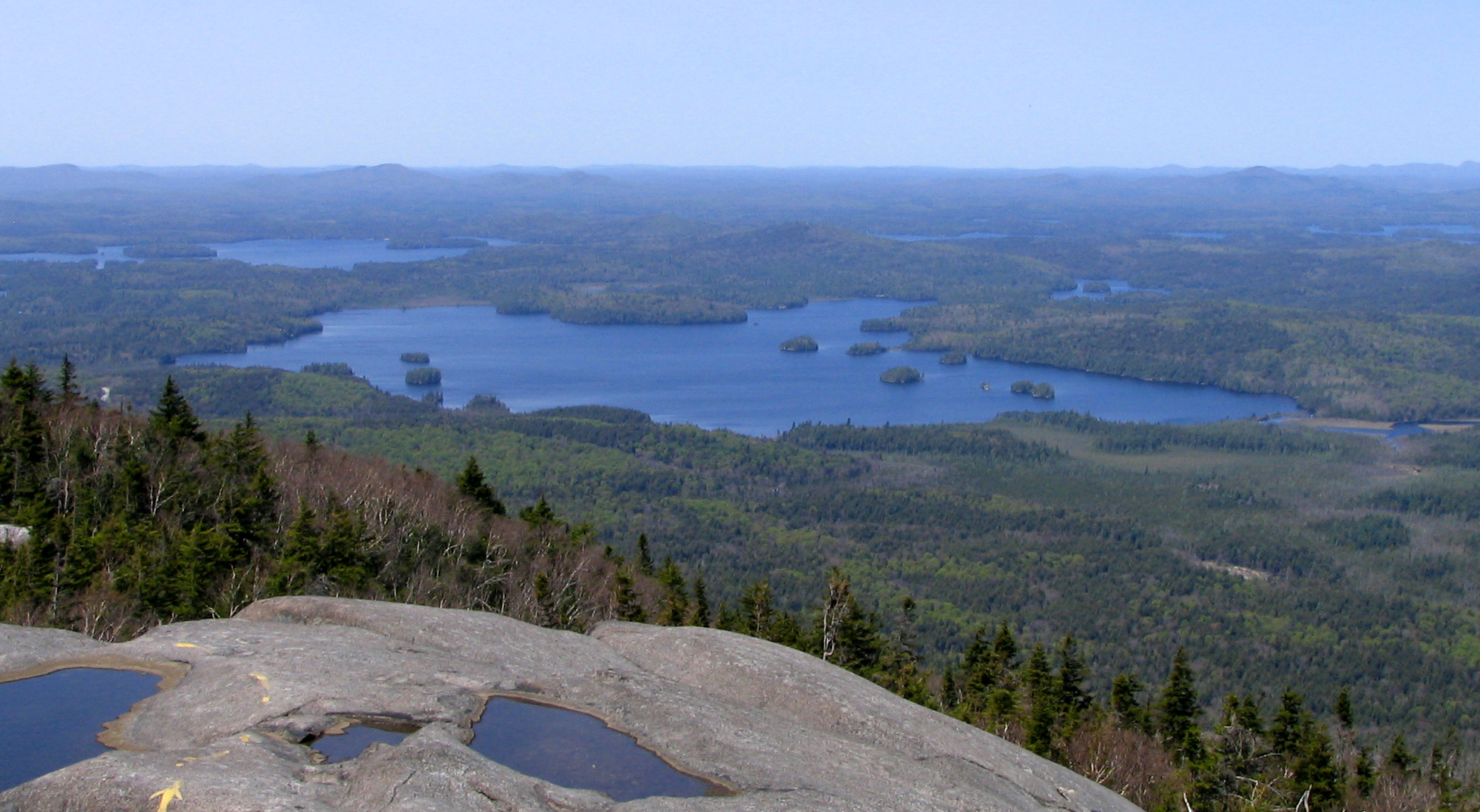
 Middle Saranac Lake from Ampersand Mountain, Upper Saranac Lake, upper right, Weller Pond, center right
 Spencer Pond and Moosehead Lake, Maine, from Little Spencer Mountain