- District Council of Lower Eyre Peninsula
-
District Council of Lower Eyre Peninsula
South Australia
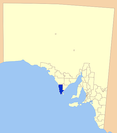
Location of the District Council of Lower Eyre PeninsulaPopulation: 4,820(2009)[1] Established: 1880 Area: 4771 km² (1,842.1 sq mi) Mayor: Max Hill Council Seat: Cummins Region: Eyre Peninsula State District: Flinders Federal Division: Grey 
LGAs around District Council of Lower Eyre Peninsula: District Council of Elliston District Council of Tumby Bay District Council of Lower Eyre Peninsula City of Port Lincoln The District Council of Lower Eyre Peninsula is a local government area located on Eyre Peninsula in South Australia. The district covers the southern tip of the peninsula, except for the small area taken up by the City of Port Lincoln.
The main council offices are in Cummins, with a branch office in Port Lincoln, even though Port Lincoln is actually in its own council area, not encompassed by the council.
Contents
History
The District Council of Lower Eyre Peninsula traces its history back to the original District Council of Port Lincoln, whose creation was proclaimed in 1880. It expanded in 1888 and 1890, then had a northern section removed to form the new District Council of Tumby Bay in 1906.[2]
Then in 1921 the Corporation of Port Lincoln was excised, and the remainder renamed to District Council of Lincoln. The boundary has moved several times since then, with The District Council of Lincoln renamed to Lower Eyre Peninsula in 1988.[2]
The area's economy is reliant mostly on agriculture, with cereal crops and sheep being prominent in the district, as in much of the Eyre Peninsula. Fishing and aquaculture are a large part of the economy also, with Coffin Bay Oysters gaining statewide recognition.[3]
The district, particularly coastal towns such as Coffin Bay are ever popular with tourists, with fishing and a variety of other water based activities a major attraction. The Coffin Bay National Park is also a major attraction, as well as an area of natural habitat conservation.[4]
Localities
The district has two major towns; Cummins and Coffin Bay, but the district covers a large area, including a number of small towns and mostly uninhabited areas. The official list of localities in the council area is:
Big Swamp, Boston, Brimpton Lake, Charlton Gully, Coffin Bay, Coomunga, Coulta, Cummins, Edillilie, Farm Beach, Flinders, Green Patch, Kapinnie, Karkoo, Kiana, Lake Wangary, Lincoln, Little Swamp, Louth, Louth Bay, Mitchell, Mortlock, Mount Drummond, Mount Dutton Bay, Mount Hope, North Shields, Poonindie, Proper Bay, Shannon, Sleaford, Sleaford Bay, Stamford, Tod River (Reservoir), Tulka, Uley, Ulipa, Wangary, Wanilla, Warrow, White Flat, Yeelanna[5]
Elected Members
Mayor: Max Hill
CEO: Peter Aird
Councillors:
- Julie Low
- Gaile Bobrige
- Leon Murray
- Paul Pedler
- Phillip Porter
- Neville Trezise
References
- ^ Australian Bureau of Statistics (30 March 2010). "Regional Population Growth, Australia, 2008–09". http://www.abs.gov.au/ausstats/abs@.nsf/Latestproducts/3218.0Main%20Features72008-09?opendocument&tabname=Summary&prodno=3218.0&issue=2008-09&num=&view=. Retrieved 4 June 2010.
- ^ a b District Council of Lower Eyre Peninsula, District History, http://www.lowereyrepeninsula.sa.gov.au/site/page.cfm?u=124, retrieved 2007-05-15
- ^ Tourism Eyre Peninsula, Coffin Bay, http://www.tep.com.au/region/coffin_bay.htm, retrieved 2007-05-15
- ^ Department of Environment and Heratige ([dead link] – Scholar search), Coffin Bay National Park, archived from the original on 26 September 2007, http://web.archive.org/web/20070926231305/http://www.parks.sa.gov.au/publish/groups/public/@parks/@lowersoutheast/documents/all/brochure_coffin_bay.pdf, retrieved 2007-05-15
- ^ "Local Government Association of South Australia, Lower Eyre Peninsula". http://www.lga.sa.gov.au/site/page.cfm?c=4167. Retrieved 2007-05-15.
External links
Towns and Localities of the District Council of Lower Eyre Peninsula Big Swamp · Boston · Brimpton Lake · Charlton Gully · Coffin Bay · Coomunga · Coulta · Cummins · Edillilie · Flinders · Green Patch · Kapinnie · Karkoo · Kiana · Lake Wangary · Lincoln · Little Swamp · Louth · Louth Bay · Mitchell · Mortlock · Mount Drummond · Mount Dutton Bay · Mount Hope · North Shields · Poonindie · Proper Bay · Shannon · Sleaford · Sleaford Bay · Stamford · Tod River · Tulka · Uley · Ulipa · Wangary · Wanilla · Warrow · White Flat · YeelannaEyre Peninsula, South Australia Cities Townships Arno Bay · Baird Bay · Ceduna · Cleve · Coffin Bay · Cowell · Cummins · Darke Peak · Denial Bay · Elliston · Iron Knob · Kimba · Kyancutta · Lock · Minnipa · Poochera · Port Kenny · Port Neill · Pygery · Sceale Bay · Smoky Bay · Streaky Bay · Thevenard · Tumby Bay · Venus Bay · Wangary · Wirrulla · Wudinna · Yaninee · YeelannaNational parks Coffin Bay National Park · Gawler Ranges National Park · Lake Gilles Conservation Park · Lincoln National ParkIslands Councils Ceduna DC · Cleve DC · Elliston DC · Franklin Harbour DC · Kimba DC · Lower Eyre Peninsula DC · City of Port Augusta · City of Port Lincoln · Streaky Bay DC · Tumby Bay DC · City of Whyalla · Wudinna DCLocal Government Areas of South Australia Metropolitan Adelaide Adelaide · Adelaide Hills · Burnside · Campbelltown · Charles Sturt · Gawler · Holdfast Bay · Marion · Mitcham · Norwood Payneham & St Peters · Onkaparinga · Playford · Port Adelaide Enfield · Prospect · Salisbury · Tea Tree Gully · Unley · Walkerville · West TorrensEyre Peninsula Ceduna · Cleve · Elliston · Franklin Harbour · Kimba · Lower Eyre Peninsula · Port Augusta · Port Lincoln · Streaky Bay · Tumby Bay · Wudinna · WhyallaCentral Barossa · Barunga West · Clare and Gilbert Valleys · Copper Coast · Flinders Ranges · Goyder · Light · Mallala · Mount Remarkable · Northern Areas · Orroroo Carieton · Peterborough · Port Pirie · Wakefield · Yorke PeninsulaSouthern and Hills Murray Mallee Southeast Outback Categories:- Populated places established in 1880
- 1880 establishments in Australia
- Local Government Areas of South Australia
- Eyre Peninsula
Wikimedia Foundation. 2010.