- District Council of Yankalilla
-
District Council of Yankalilla
South Australia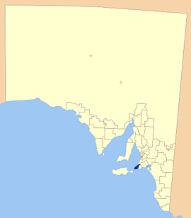
Location of the District Council of YankalillaPopulation: 4,577(2009)[1] Established: 1854 Area: 750.6 km² (289.8 sq mi) Mayor: Peter Whitford Council Seat: Yankalilla Region: Fleurieu Peninsula State District: Finniss Federal Division: Mayo 
LGAs around District Council of Yankalilla: City of Onkaparinga Alexandrina Council District Council of Yankalilla City of Victor Harbor Kangaroo Island Council Southern Ocean The District Council of Yankalilla is a Local Government Area centred on the town of Yankalilla on South Australia's Fleurieu Peninsula. The council was established in 1854, two years after legislation was passed allowing the formation of District Councils in South Australia.
The district has a rich history, as one of the earliest South Australian coastal settlements, and a wide range of agricultural activities having taken place. Today the district remains agricultural in nature, supplemented by tourism and forestry.
Contents
History
Pre-European
The Southern Fleurieu was originally inhabited by the indigenous Kaurna people, who openly met with the Ramindjeri and other peoples for trade and exchanges.[2] Aboriginal myth credits the formation of the land forms of the Southern Fleurieu to the travels of Tjilbruke as he grieved carrying the body of his nephew from the Sturt River to Cape Jervis.[3]
Evidence of Megafauna, including bones attributed to Diprotodon, Maesopus - the giant kangaroo and Thylacoleo - a marsupial lion, were discovered in the 1890s. A Diprotodon leg bone was found in a swamp in the 1890s and conjecture surrounds the possibility that the animals were hunted by local aboriginal groups.[4]
European History
The Southern Fleurieu Peninsula was first mapped by Europeans in 1802 with both the French Nicholas Baudin and the English Matthew Flinders travelling the coastline, with Baudin giving Fleurieu Peninsula its name.
William Light was the first to land on the mainland, at Rapid Bay in 1836, and declared the area "rich beyond expectation". His report resulted in the early intensive settlement of the area and the District was considered for the site of the new settlement of South Australia, before further surveying showed the site of Adelaide to be superior.[5]
Governor Hindmarsh recorded the aboriginal pronunciation of "Yoongalilla", as applied to the District and noted this in dispatches of 1837. Other legends as to the origin of the name exist, with some claims that the area was named after an American "Yankie" whaler, whose kind frequented the area at the time. There is little evidence for most of these theories however. In 1911, the town was officially proclaimed Yankalilla, which was to later become the name of the district.[6]
Whalers and sealers became the first Europeans to establish semi-permanently in the district in the early 19th century, with a whaling station established at Fisheries Beach, but a combination of ship wrecks, decreasing whale numbers and the petroleum industry forced its closure in 1855.[7]
Farming land in the District was also surveyed for purchase in 1838, with land released in 1840 and communities established at Myponga, Second Valley, Rapid Bay and later at Yankalilla. Sheep, potatoes and wheat were the first produce, with a variety of other crops grown later, including milling and the extraction of tannins from wattle bark prevalent in the district. Second Valley, Normanville and Yankalilla all had jetties constructed to serve the increasing demand for export.[5]
In 1852 the South Australian Government proclaimed an Act of Parliament appointing District Councils to administer local affairs. The District Council of Yankalilla was constituted on 5 April 1854.
The district remained an important one to the state, but as transportation improved, its proximity to Adelaide decreased its original importance and now has very little influence on the welfare of the state.[6]
Economy
A number of industries have come and gone in the district, including whaling and sealing, but agriculture now remains the staple source of the areas economy.
In the past, a number of products were farmed, including sheep, potatoes, wheat, beans, flax, tobacco, oats, maize and barley, as well as the aforementioned flour milling, timber milling and mining.[5]
Dairy farming has become a major part of the districts economy, and along with cereal crops and sheep, is the districts main source of economy. More recent developments include the trials of vineyards in the district, as well as land based aquaculture and sustainable forestry.[8]
Tourism also plays a minor role in the area, with its close proximity to Adelaide drawing large crowds to the seaside towns, especially during summer.
Localities
Larger towns governed locally by Yankalilla District Council include:
There are a number of smaller towns and moslty uninhabitd areas encompassed by the district. The full list of these is:
Bald Hills, Bullaparinga, Carrickalinga, Deep Creek, Delamere, Hay Flat, Inman Valley, Myponga Beach, Pages Flat, Parawa, Randalsea, Second Valley, Sellicks Hill, Silverton, Talisker, Torrens Vale, Tunkalilla, Wattle Flat, Willow Creek and Wirrina Cove.[9]
Elected Members
Mayor: Peter Whitford
CEO: Roger Sweetman
Councillors:
- John Hughes
- Mandy Aistrope
- Allan Barnes
- Andrew Gebhardt
- Janet Jones
- John Sanderson
- Malcolm Schlein
- Bruce Spilsbury
Council currently meets twice a month on the first and third Thursday of the month, commencing at 10.00am
References
- ^ Australian Bureau of Statistics (30 March 2010). "Regional Population Growth, Australia, 2008–09". http://www.abs.gov.au/ausstats/abs@.nsf/Latestproducts/3218.0Main%20Features72008-09?opendocument&tabname=Summary&prodno=3218.0&issue=2008-09&num=&view=. Retrieved 3 June 2010.
- ^ ACC (– Scholar search), Kaurna Tribe, archived from the original on April 3, 2007, http://web.archive.org/web/20070403153801/http://www.acc.asn.au/Kaurna.htm, retrieved 2007-06-06[dead link]
- ^ Aboriginal Education SA (PDF), Aboriginal Dreamings, archived from the original on January 26, 2007, http://web.archive.org/web/20070126041617/http://www.aboriginaleducation.sa.edu.au/files/links/Aboriginal_Dreamings_and__1.pdf, retrieved 2007-06-06
- ^ Australian Bureau of Statistics, The Geology of Australia, http://www.abs.gov.au/AUSSTATS/abs@.nsf/featurearticlesbyCatalogue/2B69A0F02F44C730CA2569DE001F1083?OpenDocument, retrieved 2007-06-06
- ^ a b c DC of Yankalilla, History, http://www.yankalilla.sa.gov.au/site/page.cfm?u=140, retrieved 2007-06-06
- ^ a b Walkabout South Australia, Yankalilla, http://walkabout.com.au/locations/SAYankalilla.shtml, retrieved 2007-06-06
- ^ Sydney Morning Herald tourism (2004-02-08), Yankalilla, The Sydney Morning Herald, http://www.smh.com.au/news/south-australia/yankalilla/2005/02/17/1108500204820.html, retrieved 2007-06-06
- ^ DC of Yankalilla, Agriculture and Primary Production, http://www.yankalilla.sa.gov.au/site/page.cfm?u=236, retrieved 2007-06-06
- ^ LGA of SA, DC of Yankalilla, http://www.lga.sa.gov.au/site/page.cfm?c=4177, retrieved 2007-06-06
External links
Local Government Areas of South Australia Metropolitan Adelaide Adelaide · Adelaide Hills · Burnside · Campbelltown · Charles Sturt · Gawler · Holdfast Bay · Marion · Mitcham · Norwood Payneham & St Peters · Onkaparinga · Playford · Port Adelaide Enfield · Prospect · Salisbury · Tea Tree Gully · Unley · Walkerville · West TorrensEyre Peninsula Ceduna · Cleve · Elliston · Franklin Harbour · Kimba · Lower Eyre Peninsula · Port Augusta · Port Lincoln · Streaky Bay · Tumby Bay · Wudinna · WhyallaCentral Barossa · Barunga West · Clare and Gilbert Valleys · Copper Coast · Flinders Ranges · Goyder · Light · Mallala · Mount Remarkable · Northern Areas · Orroroo Carieton · Peterborough · Port Pirie · Wakefield · Yorke PeninsulaSouthern and Hills Murray Mallee Southeast Outback Coordinates: 35°27′18″S 138°20′08″E / 35.455°S 138.335555556°E
Categories:- Populated places established in 1854
- 1854 establishments in Australia
- Local Government Areas of South Australia

Wikimedia Foundation. 2010.