- Naracoorte Lucindale Council
-
Naracoorte Lucindale Council
South Australia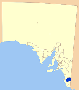
Position of the Naracoorte Lucindale Council in bluePopulation: 8,489(2009)[1] Established: 1993 Area: 4516.7 km² (1,743.9 sq mi) Mayor: Ken Grundy Council Seat: Naracoorte Region: Limestone Coast State District: MacKillop Federal Division: Barker 
LGAs around Naracoorte Lucindale Council: Kingston District Council Tatiara District Council Naracoorte Lucindale Council West Wimmera (Vic) District Council of Robe Wattle Range Council The Naracoorte Lucindale Council is a local government area located inland from the Limestone Coast, adjacent to the Victorian border in south eastern South Australia. The council encompasses the previous governing bodies of the District Council of Naracoorte, the District Council of Lucindale and the Corporate Township of Naracoorte which amalgamated in 1993.[2]
The districts economy is agricultural based, with cereal crops, sheep and beef predominantly farmed. Naracoorte has a substantial tourist industry as well, with the Naracoorte Caves, Wonambi Fossil Centre and the seasonal Bool Lagoon Game Reserve Wetlands the main attractions.[3]
Contents
Localities
The council encompasses the major towns of Naracoorte and Lucindale, as well as a number of smaller towns and surrounding areas. The full list includes:
Avenue Range, Binnum, Biscuit Flat, Bool Lagoon, Callendale, Coles, Conmurra, Conmurra South, Fox, Frances, Hynam, Jessie, Joanna, Joyce, Keppoch, Koppamurra, Kybybolite, Lochaber, Lucindale, Naracoorte, Robertson, Spence, Stewarts Range, Struan, Townsend, Woolumbool and Wrattonbully.[4]
Facilities
The towns of Naracoorte and Lucindale collectively have all major facilities expected by visitors to the area, including supermarkets, specialty stores, restaurants and accommodation in a range of forms.
The district has a number of education and health facilities, with Naracoorte having a high school and 3 primary schools, a hospital, the Naracoorte Swimming Lake and Lucindale a public library and Area School.
The area also has a number of sporting clubs.
Elected Members
Mayor: Ken Grundy
CEO: Andrew Evans
Councillors:
- Jim James
- Trevor Rayner
- Ann Bell
- Scott McLachlan
- David Hood
- Ashley Jared
- Jamie Kelly
- Craig McGuire
- Erika Vickery
- Jenny Wisbey
References
- ^ Australian Bureau of Statistics (30 March 2010). "Regional Population Growth, Australia, 2008–09". http://www.abs.gov.au/ausstats/abs@.nsf/Latestproducts/3218.0Main%20Features72008-09?opendocument&tabname=Summary&prodno=3218.0&issue=2008-09&num=&view=. Retrieved 3 June 2010.
- ^ Naracoorte Lucindale Council, Development Plan, http://www.naracoortelucindale.sa.gov.au/site/page.cfm?u=170, retrieved 2007-05-04
- ^ Naracoorte tourism, Lucindale, http://www.naracoortetourism.com.au/, retrieved 2007-05-04
- ^ LGA of South Australia, Naracoorte Lucindale Council, http://www.lga.sa.gov.au/site/page.cfm?c=4187, retrieved 2007-05-04
External links
Local Government Areas of South Australia Metropolitan Adelaide Adelaide · Adelaide Hills · Burnside · Campbelltown · Charles Sturt · Gawler · Holdfast Bay · Marion · Mitcham · Norwood Payneham & St Peters · Onkaparinga · Playford · Port Adelaide Enfield · Prospect · Salisbury · Tea Tree Gully · Unley · Walkerville · West TorrensEyre Peninsula Ceduna · Cleve · Elliston · Franklin Harbour · Kimba · Lower Eyre Peninsula · Port Augusta · Port Lincoln · Streaky Bay · Tumby Bay · Wudinna · WhyallaCentral Barossa · Barunga West · Clare and Gilbert Valleys · Copper Coast · Flinders Ranges · Goyder · Light · Mallala · Mount Remarkable · Northern Areas · Orroroo Carieton · Peterborough · Port Pirie · Wakefield · Yorke PeninsulaSouthern and Hills Murray Mallee Southeast Outback Coordinates: 36°57′22″S 140°44′29″E / 36.9561111111°S 140.741388889°E
Categories:- Populated places established in 1993
- 1993 establishments in Australia
- Local Government Areas of South Australia
- Limestone Coast

Wikimedia Foundation. 2010.