- District Council of Kimba
-
District Council of Kimba
South Australia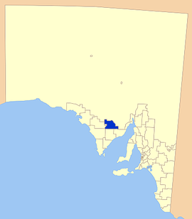
Location of the District Council of KimbaPopulation: 1,125(2009)[1] Established: 1924 Area: 3986.2 km² (1,539.1 sq mi) Mayor: John Schaefer Council Seat: Kimba Region: Eyre Peninsula State District: Flinders Federal Division: Grey 
LGAs around District Council of Kimba: Outback Areas Community Development Trust Wudinna District Council District Council of Kimba District Council of Elliston District Council of Cleve District Council of Franklin Harbour The District Council of Kimba is a local government area located on the northern Eyre Peninsula in South Australia. The district is mostly agricultural in nature, with the township of Kimba being the focal point of the district. With a number of towns positioned close to the Gawler Ranges, the district receives a modest amount of attention from tourists, who also stop by to see Kimba's Big Galah.[2]
Contents
History
Pastoralists began colonising the area that would become the district in the early 1900s without many essential facilities such as road and water supplies. In 1913 the Port Lincoln Railway was extended to a new siding named 'Kimba', and two years later, the town of Kimba was officially proclaimed.[3]
With new settlers to the area, the need for basic facilities was growing, and the forerunner to the council, the Kimba Vigilance Committee was established to lobby for the provision of these facilities. In 1924, the District Council of Kimba was finally established by Government proclamation.
Since 1924, the district has grown in size, with a number of areas being added during 1936-1937, and again in 1967.[3]
In 2009 the Mobil gas station was burnt to the ground by electrical faults.
Localities
Although Kimba is the districts major town, it covers a much larger area, including a number of towns and sparsely populated agricultural areas including:
Barna, Buckleboo, Caralue, Cootra, Coorobinnie, Cortlinye, Cunyarie, Kelly, Kimba, Moseley, Panitya, Peela, Pinkawillinie, Solomon, Wilcherry, Yalanda.[4]
Facilities
The district has most essential facilities available including service stations, automotive repairers, laundromat, learning and business centre, accommodation, supermarkets, speciality shops, and many eating facilities.[3]
Other community services include a medical centre, a hospital, a library and school
Elected Members
Mayor: John Schaefer
CEO: Daryl Cearns
Councillors:
- Carolyn Haskett
- Dianne Hamlyn
- Dean Johnson
- Bruce Mathews
- Colin Rayson
- Dianne McDonald
References
- ^ Australian Bureau of Statistics (30 March 2010). "Regional Population Growth, Australia, 2008–09". http://www.abs.gov.au/ausstats/abs@.nsf/Latestproducts/3218.0Main%20Features72008-09?opendocument&tabname=Summary&prodno=3218.0&issue=2008-09&num=&view=. Retrieved 4 June 2010.
- ^ Nullabor Travel net, Kimba, http://www.nullarbornet.com.au/towns/kimba.html, retrieved 2007-05-18
- ^ a b c District Council of Kimba, District History, http://www.kimba.sa.gov.au/site/page.cfm?u=100, retrieved 2007-05-18
- ^ Local Government of South Australia Association, DC of Kimba, http://www.lga.sa.gov.au/site/page.cfm?c=4165, retrieved 2007-05-18
External links
Towns and localities of the District Council of Kimba Local Government Areas of South Australia Metropolitan Adelaide Adelaide · Adelaide Hills · Burnside · Campbelltown · Charles Sturt · Gawler · Holdfast Bay · Marion · Mitcham · Norwood Payneham & St Peters · Onkaparinga · Playford · Port Adelaide Enfield · Prospect · Salisbury · Tea Tree Gully · Unley · Walkerville · West TorrensEyre Peninsula Ceduna · Cleve · Elliston · Franklin Harbour · Kimba · Lower Eyre Peninsula · Port Augusta · Port Lincoln · Streaky Bay · Tumby Bay · Wudinna · WhyallaCentral Barossa · Barunga West · Clare and Gilbert Valleys · Copper Coast · Flinders Ranges · Goyder · Light · Mallala · Mount Remarkable · Northern Areas · Orroroo Carieton · Peterborough · Port Pirie · Wakefield · Yorke PeninsulaSouthern and Hills Murray Mallee Southeast Outback Coordinates: 33°08′00″S 136°25′00″E / 33.1333333333°S 136.416666667°E
Categories:- Populated places established in 1924
- 1924 establishments in Australia
- Local Government Areas of South Australia
- Eyre Peninsula

Wikimedia Foundation. 2010.