- District Council of Mallala
-
District Council of Mallala
South Australia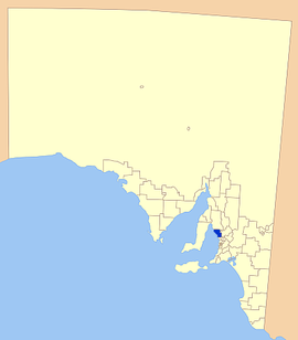
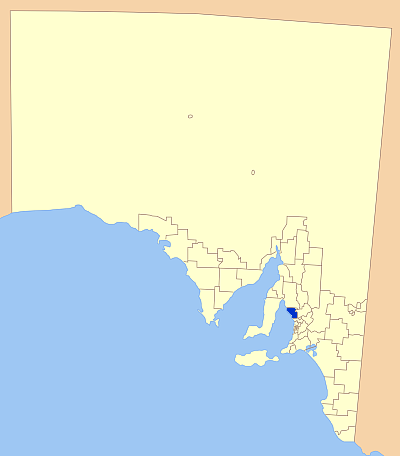
Location of the District Council of MallalaPopulation: 8,385(2009)[1] Established: 1935, renamed 15 April 1937 Area: 932.1 km² (359.9 sq mi) Mayor: Marcus Strudwicke LGAs around District Council of Mallala: Wakefield Regional Council District Council of Mallala Light Regional Council City of Playford The District Council of Mallala was originally proclaimed in 1935 as the District Council of Light. It is the result of the amalgamation of the District Councils of Dublin, Port Gawler and Grace Plains. The District Council of Light was renamed the District Council of Mallala on 15 April 1937.
The first white settlement of the area dates back to the Port Gawler Special Survey in 1839. Originally the land was inhabited by the Kaurna people whose territory extended in a narrow corridor along the eastern shore of Gulf St Vincent; Cape Jervis to Port Wakefield; inland to near Crystal Brook, Snowtown, Blyth, Hoyleton, Hamley Bridge, Clarendon, Gawler, and Myponga; from the east side of the Hummock Range to Red Hill. Inland the stringy bark forests of the Mount Lofty Ranges marked their boundary.
Throughout the district large tracts of surveyed land were allotted to pastoralists who farmed mostly grain and sheep. The early produce of the area was often shipped out on ketches from the Ports of Gawler and Parham.
Both the Light River and the Gawler River pass through the district and the rich fertile plains are ideal for vegetable production, the majority of which is sent to the nearby Adelaide markets. As well as the general agricultural pursuits of grain growing and storage and running livestock, other major industries in the region include the livestock market / sale yards, metal fabrication and manufacture of industrial equipment.
Major towns
Major towns that were established early on include Two Wells, Mallala and Dublin, along with settlements at Barabba, Port Gawler, Redbanks, Wild Horse Plains and Port Parham.
References
- ^ Australian Bureau of Statistics (30 March 2010). "Regional Population Growth, Australia, 2008–09". http://www.abs.gov.au/ausstats/abs@.nsf/Latestproducts/3218.0Main%20Features72008-09?opendocument&tabname=Summary&prodno=3218.0&issue=2008-09&num=&view=. Retrieved 4 June 2010.
External links
Local Government Areas of South Australia Metropolitan Adelaide Adelaide · Adelaide Hills · Burnside · Campbelltown · Charles Sturt · Gawler · Holdfast Bay · Marion · Mitcham · Norwood Payneham & St Peters · Onkaparinga · Playford · Port Adelaide Enfield · Prospect · Salisbury · Tea Tree Gully · Unley · Walkerville · West TorrensEyre Peninsula Ceduna · Cleve · Elliston · Franklin Harbour · Kimba · Lower Eyre Peninsula · Port Augusta · Port Lincoln · Streaky Bay · Tumby Bay · Wudinna · WhyallaCentral Barossa · Barunga West · Clare and Gilbert Valleys · Copper Coast · Flinders Ranges · Goyder · Light · Mallala · Mount Remarkable · Northern Areas · Orroroo Carieton · Peterborough · Port Pirie · Wakefield · Yorke PeninsulaSouthern and Hills Murray Mallee Southeast Outback Coordinates: 34°26′16″S 138°30′45″E / 34.43790306°S 138.51247°E
Categories:
Wikimedia Foundation. 2010.