- District Council of Grant
-
District Council of Grant
South Australia
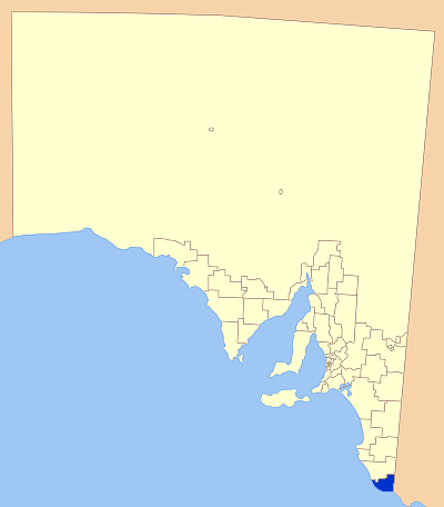
Location of the District Council of GrantPopulation: 8,652(2009)[1] Established: 1996 Area: 1904 km² (735.1 sq mi) The District Council of Grant completely surrounds but does not include the City of Mount Gambier. Mayor: Don Pegler Council Seat: Mount Gambier Region: Limestone Coast State District: Mount Gambier Federal Division: Barker 
LGAs around District Council of Grant: Wattle Range Council District Council of Grant Glenelg (Vic) The District Council of Grant is a local government area located in the Limestone Coast region of South Australia, and is the southernmost council in the state.
The council was formed in 1996, after the amalgamation of the District Councils of Mount Gambier and Port MacDonnell, and currently surrounds the City of Mount Gambier local government area. The economy of the district is based around agriculture, forestry and fishing.
Contents
History
The District Council of Mount Gambier
Local government in Mount Gambier was established in 1863, when the District Council of Mount Gambier met for the first time, and Dr Edward Wehl was elected the inaugural Chairman. In December 1864 the District Council of Mount Gambier was divided into the District Council of Mount Gambier West (Town Council) and the District Council of Mount Gambier East. In May 1876 another division occurred resulting in the formation of the first Town Council with Mr John Watson as Mayor.[2]
The three local governments operated independently up until 1932 when the District Council of Mount Gambier West and District Council of Mount Gambier East were merged to once again be united under the banner of the District Council of Mount Gambier. The town council never merged back, instead becoming what is now the City of Mount Gambier.[2]
The District Council of Port MacDonnell
Land around Port MacDonnell was taken up by pastoralists as early as the 1840s. Settlement started in the 1850s.
By the end of the 1860s there were enough people in town and surrounding smaller settlements to warrant the proclamation of the District Council of Port MacDonnell.[3]
With Port MacDonnell being the second largest port in South Australia, the population held steady until the decision was made not to connect the port to the newly south east railway network. This resulted in loss of trade, and declining populations in the town.[3]
The two councils merged in 1996 to form the District Council of Grant.[4]
Economy
The economy of the district relies on a range of industries, including agriculture, fishing, forestry and tourism.
Cereal crops and horticulture dominate many agricultural areas in the district, with beef, dairy and sheep production also prominent activities.
The fishing industry in Port MacDonnell is mostly reliant on the rock lobster industry, as well as certain scalefish, and is a significant factor in the economy of the area.
Forestry production and related secondary industries of logging, milling and paper production are major economic and employment generating activities.
Tourists are attracted to the district by natural features such as the coastline, the Canunda National Park and Lake Bonney as well as the European heritage making the area a popular and growing tourist destination.[4]
During autumn, many visitors also arrive to take advantage of the run of Bluefin Tuna along the coast, with fish caught out over the edge of the continental shelf.
Localities
The seat of council is actually located in Mount Gambier, although that city is not included in the council area, making Port MacDonnell the largest town in the district. There many small towns and isolated areas encompassed in the region as well. These are:
Allendale East, Blackfellows Caves, Burrungule, Canunda, Cape Douglas, Caroline, Carpenter Rocks Caveton, Compton, Dismal Swamp, Donovans, Eight Mile Creek, German Creek, Glenburnie, Kongrong, Mil-Lel, Mingbool, Moorak, Mount Schank, Nene Valley, O B Flat, Pelican Point, Pleasant Park, Port MacDonnell, Racecourse Bay, Square Mile, Suttontown, Tantanoola, Tarpeena, Wandilo, Wepar, Worrolong, Wye and Yahl.[5]
Elected Members
CEO: Russell Peate
Councillors:
- Brian Collins
- Shane Taylor
- Bruce Bain
- Alan Hill
- Alex Deak
- Shirley Little
- Malcolm Porter
- Jeanenne Morgan
- Richard Sage
References
- ^ Australian Bureau of Statistics (30 March 2010). "Regional Population Growth, Australia, 2008–09". http://www.abs.gov.au/ausstats/abs@.nsf/Latestproducts/3218.0Main%20Features72008-09?opendocument&tabname=Summary&prodno=3218.0&issue=2008-09&num=&view=. Retrieved 3 June 2010.
- ^ a b Mount Gambier City Council ([dead link] – Scholar search), History, archived from the original on 2007-07-01, http://web.archive.org/web/20070701021318/http://www.mountgambier.sa.gov.au/your_council.htm, retrieved 2007-05-30
- ^ a b Flinders Ranges History, Port MacDonnell, http://www.southaustralianhistory.com.au/portmacdonnell.htm, retrieved 2007-05-30
- ^ a b District Council of Grant, Profile, http://www.dcgrant.sa.gov.au, retrieved 2007-05-30
- ^ LGA of South Australia, DC of Grant, http://www.lga.sa.gov.au/site/page.cfm?c=4163, retrieved 2007-05-30
External links
Local Government Areas of South Australia Metropolitan Adelaide Adelaide · Adelaide Hills · Burnside · Campbelltown · Charles Sturt · Gawler · Holdfast Bay · Marion · Mitcham · Norwood Payneham & St Peters · Onkaparinga · Playford · Port Adelaide Enfield · Prospect · Salisbury · Tea Tree Gully · Unley · Walkerville · West TorrensEyre Peninsula Ceduna · Cleve · Elliston · Franklin Harbour · Kimba · Lower Eyre Peninsula · Port Augusta · Port Lincoln · Streaky Bay · Tumby Bay · Wudinna · WhyallaCentral Barossa · Barunga West · Clare and Gilbert Valleys · Copper Coast · Flinders Ranges · Goyder · Light · Mallala · Mount Remarkable · Northern Areas · Orroroo Carieton · Peterborough · Port Pirie · Wakefield · Yorke PeninsulaSouthern and Hills Murray Mallee Southeast Outback Coordinates: 37°50′00″S 140°47′00″E / 37.8333333333°S 140.783333333°E
Categories:- Populated places established in 1996
- 1996 establishments in Australia
- Local Government Areas of South Australia
- Limestone Coast

Wikimedia Foundation. 2010.