- City of Port Adelaide Enfield
-
City of Port Adelaide Enfield
South Australia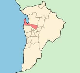
Population: 111,455(2009)[1] Area: 97 km² (37.5 sq mi) Mayor: Gary Johanson Council Seat: Port Adelaide Region: Metropolitan Adelaide State District: Port Adelaide, Lee, Cheltenham, Croydon, Ramsay, Playford, Enfield, Torrens, Florey Federal Division: Port Adelaide, Adelaide, Bonython, Makin, Mayo, Sturt LGAs around City of Port Adelaide Enfield: City of Salisbury City of Port Adelaide Enfield City of Tea Tree Gully City of Charles Sturt City of Prospect City of Campbelltown The City of Port Adelaide Enfield was established on 1 January 1997 by the amalgamation of the City of Port Adelaide and the City of Enfield, and is one of the larger metropolitan councils within South Australia.
Extending from the River Torrens to Outer Harbor, and covering an area of approximately 97 km², the City offers some of the South Australia's finest historical buildings and landmarks, together with a wealth of beautiful parks and excellent cultural and recreational facilities.
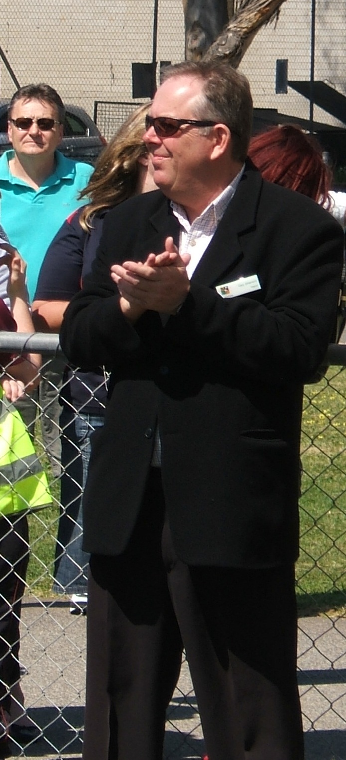
The current Mayor, elected in 2006, is Gary Johanson. There are 17 Ward Councillors who represent the residents and businesses of their wards at council meetings.
The Port Adelaide area is known as the History Precinct, as it is home to the Maritime Museum, the National Railway Museum and the Aviation Museum.
Contents
Suburbs
- Alberton - 5014
- Angle Park - 5010
- Birkenhead - 5015
- Blair Athol - 5084
- Broadview - 5083
- Clearview - 5085
- Croydon Park - 5008
- Devon Park - 5008
- Dernancourt - 5075
- Dry Creek - 5094
- Dudley Park - 5008
- Enfield - 5085
- Ethelton - 5015
- Exeter - 5019
- Ferryden Park - 5010
- Findon - 5023
- Gepps Cross - 5094
- Gilles Plains - 5086
- Gillman - 5013
- Glanville - 5015
- Greenacres - 5086
- Hampstead Gardens - 5086
- Hillcrest - 5086
- Holden Hill - 5088
- Kilburn - 5084
- Klemzig - 5087
- Largs Bay - 5016
- Largs North - 5016
- Manningham - 5086
- Mansfield Park - 5012
- North Haven - 5018
- Northfield - 5085
- Northgate - 5085
- Oakden - 5086
- Osborne - 5017
- Ottoway - 5013
- Outer Harbor - 5018
- Peterhead - 5016
- Port Adelaide - 5015
- Queenstown - 5014
- Regency Park - 5010
- Rosewater - 5013
- Sefton Park - 5083
- Semaphore - 5019
- Semaphore South - 5019
- Taperoo - 5017
- Valley View - 5093
- Walkley Heights - 5098
- Windsor Gardens - 5087
- Wingfield - 5013
- Woodville Gardens - 5012
Early port suburb division names
From the late 1830s to 1945, the area surrounding Port Adelaide was subdivided into many small district areas as owners bought, subdivided and sold areas of land. As the areas became smaller, and more landowners named their own estates, the number of these early “suburbs” reached 90. By the 1940s this was becoming a problem, so the Port Adelaide Council moved to reduce the number of local district areas to 18, in 1945. The boundaries and names of the suburbs were further stabilised when postcodes were introduced to Australia in 1967.[2]
Modern Name Early Subdivision Name Alberton Albert Town, Glebe Birkenhead Bridgetown, Bridgewater, Davies Town, Sandwell Cheltenham Franklin Ethelton Thornton Exeter Bath, Davies Town, Fisherville, Freshwater, Greenwich, Staplehurst, Waterville Gillman Newshaven, North Arm, Northarmton Glanville Port Bridge, Waterville Largs Bay Eastbourne, Ferryville, Guilford, Harveyton, Hastings, Newport, Shoreham, Ward Town, Margate Largs North London, Swansea, Largs Bay Estate Osborne Brooklyn, Mascotte, Midlunga, Blackpool, Austral-Brindisi Estate Ottoway Guildford Park, Hardwicke, Norbiton, Sassafras Estate, Whiteville Outer Harbor Eurimbla, Harbour Park, Portsmouth Pennington Everton Peterhead Farnham, Gold Diggers Village, Hamley, Sandwell Port Adelaide Greytown, Moilong, Newhaven, Portland Estate, Portsea Rosewater Bayswater, Paddington, Dockville, Perth, Yatala, Rosatala, Kingsnorth, Greytown, Kingston, Kingston East, Kelmscott, Rosewater East Semaphore Alderley, Clairville, Clifton, Freshwater, Kew, New Liverpool, Plymouth, Scarborough, Weymouth Semaphore Park Balmoral, Beaumont, Bristol, Clevedon, Davington, Mellor Park, Weston Point, Williamstown Semaphore South Saint Margaret's, Thornton, Whitby Taperoo Draper, Gedville Estate, Koolena, Kooraka, River View, Silicate, Silicate Beach Wingfield Brooklyn, Dundas, Hull, Millicent, Myrtlehome, Newark, Norahville, Rosslyn, Wicklow  City of Enfield crest (-1996)
Sister cities
See also
- List of Adelaide suburbs
- Local Government Areas of South Australia
- James Millner (doctor)
References
 Mayor Gary Johanson
Couper-Smartt, J (2003). Port Adelaide: Tales from a "Commodious Harbour". Friends of the South Australian Maritime Museum Inc. ISBN 0-646-42058-5.
Footnotes
- ^ Australian Bureau of Statistics (30 March 2010). "Regional Population Growth, Australia, 2008–09". http://www.abs.gov.au/ausstats/abs@.nsf/Latestproducts/3218.0Main%20Features72008-09?opendocument&tabname=Summary&prodno=3218.0&issue=2008-09&num=&view=. Retrieved 4 June 2010.
- ^ Couper-Smartt, 2003:167
- ^ Sistercities.org
- ^ Malmö stads vänortssamarbete
External links
Local Government Areas of South Australia Metropolitan Adelaide Adelaide · Adelaide Hills · Burnside · Campbelltown · Charles Sturt · Gawler · Holdfast Bay · Marion · Mitcham · Norwood Payneham & St Peters · Onkaparinga · Playford · Port Adelaide Enfield · Prospect · Salisbury · Tea Tree Gully · Unley · Walkerville · West TorrensEyre Peninsula Ceduna · Cleve · Elliston · Franklin Harbour · Kimba · Lower Eyre Peninsula · Port Augusta · Port Lincoln · Streaky Bay · Tumby Bay · Wudinna · WhyallaCentral Barossa · Barunga West · Clare and Gilbert Valleys · Copper Coast · Flinders Ranges · Goyder · Light · Mallala · Mount Remarkable · Northern Areas · Orroroo Carieton · Peterborough · Port Pirie · Wakefield · Yorke PeninsulaSouthern and Hills Murray Mallee Southeast Outback Categories:- Local Government Areas in Adelaide
- Local Government Areas of South Australia

Wikimedia Foundation. 2010.