- Southern Mallee District Council
-
Southern Mallee District Council
South Australia
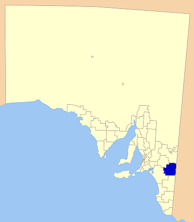
The position of Southern Mallee District Council in SA.Population: 2,189(2009)[1] Established: 1 July 1997 Area: 6000 km² (2,316.6 sq mi) 
LGAs around Southern Mallee District Council: Karoonda East Murray Loxton Waikerie The Coorong Southern Mallee District Council West Wimmera (Vic) The Coorong Tatiara The Southern Mallee District Council is a Local Government Area in the Murray Mallee region of South Australia. The council offices are in Pinnaroo and Lameroo[2].
Towns and localities in the council area are Geranium, Gurrai, Karte, Kulkami, Lameroo, Parilla, Parrakie, Pinnaroo, Wilkawatt. Some of these have become no more than localities on a map as farms amalgamate, but others are still viable country towns, especially the ones along the Mallee Highway. The largest are Pinnaroo and Lameroo with populations of 700 and 600 respectively.
The neighbouring councils are Tatiara District Council to the south, Coorong District Council to the southwest, District Council of Karoonda East Murray to the north west, District Council of Loxton Waikerie to the north, and the Victorian border to the east.
External links
References
- ^ Australian Bureau of Statistics (30 March 2010). "Regional Population Growth, Australia, 2008–09". http://www.abs.gov.au/ausstats/abs@.nsf/Latestproducts/3218.0Main%20Features72008-09?opendocument&tabname=Summary&prodno=3218.0&issue=2008-09&num=&view=. Retrieved 3 June 2010.
- ^ "District Offices". Southern Mallee District Council. 2005-03-15. http://www.southernmallee.sa.gov.au/site/page.cfm?u=129. Retrieved 2007-04-09.
Local Government Areas of South Australia Metropolitan Adelaide Adelaide · Adelaide Hills · Burnside · Campbelltown · Charles Sturt · Gawler · Holdfast Bay · Marion · Mitcham · Norwood Payneham & St Peters · Onkaparinga · Playford · Port Adelaide Enfield · Prospect · Salisbury · Tea Tree Gully · Unley · Walkerville · West TorrensEyre Peninsula Ceduna · Cleve · Elliston · Franklin Harbour · Kimba · Lower Eyre Peninsula · Port Augusta · Port Lincoln · Streaky Bay · Tumby Bay · Wudinna · WhyallaCentral Barossa · Barunga West · Clare and Gilbert Valleys · Copper Coast · Flinders Ranges · Goyder · Light · Mallala · Mount Remarkable · Northern Areas · Orroroo Carieton · Peterborough · Port Pirie · Wakefield · Yorke PeninsulaSouthern and Hills Murray Mallee Berri Barmera · The Coorong · Gerard · Karoonda East Murray · Loxton Waikerie · Mid Murray · Murray Bridge · Renmark Paringa · Southern MalleeSoutheast Outback Coordinates: 35°15′36″S 140°54′31″E / 35.26°S 140.908611111°E
Categories:
Wikimedia Foundation. 2010.