- Mallee Highway
-
Mallee Highway 
Formerly 
Length 377 km (234 mi) Direction West-East From  Dukes Highway,
Tailem Bend, South Australiavia Lameroo, Pinnaroo, Ouyen, Manangatang To  Murray Valley Highway,
Piangil, VictoriaMajor junctions  Calder Highway
for full list see major intersections
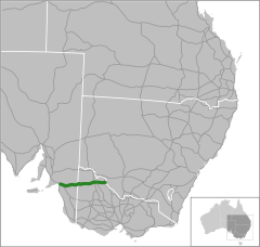
The Mallee Highway (formerly the Ouyen Highway on the Victoria side) runs east from Tailem Bend in South Australia through cereal-growing farmland at the southern end of the Murray Mallee to Pinnaroo near the border with Victoria, where it crosses route _(from_
 (from Bordertown to Loxton). It continues in Victoria through Ouyen, where it crosses the Calder Highway
  (the old Ouyen Highway finished here and never proceeded east), and Piangil, where it crosses the Murray Valley Highway
  .
. , however continues past the Mallee Highway terminus along the Murray Valley Highway for two kilometres north of Piangil, linking to Tooleybuc Road where the continues until it crosses the New South Wales border and the Murray River at Tooleybuc. The road then continues to Balranald, at the Murrumbidgee River. Tooleybuc Road terminates at the Sturt Highway
  and continues en route to Sydney via the Hume Highway
  .
.Major intersections and towns
Mallee Highway 
Westbound Distance to
Adelaide
(km)Distance to
Swan Hill
(km)Eastbound  T-Intersection (clockwise from highway)
Dukes Highway to Bordertown and Melbourne
Dukes Highway to  Princes Highway via Tailem Bend and Adelaide
End Mallee Highway 100 414 Start Mallee Highway Coomandook
Old Dukes Highway114 400 Coomandook
Old Dukes HighwayTAILEM BEND-PINNAROO RAIL LINE

152 362 TAILEM BEND-PINNAROO RAIL LINE
Lameroo 199 315 Lameroo TAILEM BEND-PINNAROO RAIL LINE
208 306 TAILEM BEND-PINNAROO RAIL LINE
continues as 233 281 Bordertown, Naracoorte
Pinnaroo-Bordertown Road _ Bordertown, Naracoorte
Pinnaroo-Bordertown Road _ _duplexes_with_ duplexes with _duplexes_with_ duplexes with 239 275 Pinnaroo Loxton, Renmark
Pinnaroo-Loxton Road _ Loxton, Renmark
Pinnaroo-Loxton Road _ Pinnaroo continues as SOUTH AUSTRALIA
STATE BORDER
VICTORIAPINNAROO RAIL LINE
245 269 PINNAROO RAIL LINE
PINNAROO RAIL LINE
265 249 PINNAROO RAIL LINE
Murrayville 266 248 Murrayville PINNAROO RAIL LINE
270 244 PINNAROO RAIL LINE
PINNAROO RAIL LINE
306 208 PINNAROO RAIL LINE
Boinka 307 207 Boinka Underbool 326 188 Underbool Patchewollock
Walpeup-Patchewollock Road _
346 168 Walpeup Walpeup Patchewollock, Hopetoun
Walpeup-Patchewollock Road _ To Patchewollock, Hopetoun
Ouyen-Patchewollock Road374 140 Patchewollock
Ouyen-Patchewollock RoadPINNAROO RAIL LINE
PINNAROO RAIL LINE
MILDURA RAIL LINE
375.7 138.3 Ouyen MILDURA RAIL LINE
continues as To  Ballarat;
Bendigo, Melbourne
Calder Highway To Ballarat;
Bendigo, Melbourne
Calder Highway duplexes with duplexes with 375.8 138.2 Red Cliffs, Mildura
Calder Highway Red Cliffs, Mildura
Calder Highway Ouyen continues as Manangatang 431 83 Manangatang Sea Lake, Robinvale
Robinvale-Sea Lake Road _
Robinvale, Sea Lake
Robinvale-Sea Lake Road _ ROBINVALE RAIL LINE
ROBINVALE RAIL LINE
Piangil 470 44 Piangil Start Mallee Highway 472 42 End Mallee Highway T-Intersection (clockwise from highway)
Murray Valley Highway to Robinvale and Sydney
Murray Valley Highway to Swan Hill and MelbourneSee also
- Highways in Australia
- Highways in Victoria
- List of highways in New South Wales
- List of highways in South Australia
References
"RAA Strip map". Adelaide-Sydney via Mallee, Sturt & Hume Hwys. http://www.raa.net/members_only.asp?file=SectionPDF_58.pdf. Retrieved 2005-01-07.
 Road infrastructure in South Australia
Freeways 
Interstate Highways State Highways Barossa Valley Highway • Flinders Highway • Glenelg Highway • Lincoln Highway • Mallee Highway • Riddoch Highway • Southern Ports Highway • Tod Highway • Wimmera HighwayRoads Adelaide Mannum Road • Gorge Road • Macclesfield Road • Onkaparinga Valley Road • Main South Road • Strathalbyn-Goolwa Road • Wellington RoadOutback Tracks  Road infrastructure in Victoria
Freeways Highways Bass Highway • Bellarine Highway • Borung Highway • Calder Highway • Glenelg Highway • Goulburn Valley Highway • Hamilton Highway • Henty Highway • Hopkins Highway • Kiewa Valley Highway • Loddon Valley Highway • Mallee Highway • Maroondah Highway • Melba Highway • Midland Highway • Monaro Highway • Murray Valley Highway • Nepean Highway • Northern Highway • Omeo Highway • Princes Highway • Pyrenees Highway • South Gippsland Highway • Strzelecki Highway • Sturt Highway • Sunraysia Highway • Surf Coast Highway • Warburton Highway • Western Highway • Western Port Highway • Wimmera HighwayBypass routes Old Hume Highway • Old Princes Highway • Princes Highway (Geelong)Tourist routes Categories:- Australian highways
- Highways in South Australia
- Highways in Victoria (Australia)
- Mallee (Victoria)
- Australia road stubs

Wikimedia Foundation. 2010.