- District Council of Clare and Gilbert Valleys
-
District Council of Clare and Gilbert Valleys
South Australia
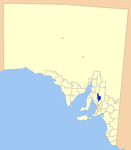
Location of District Council of Clare and Gilbert ValleysPopulation: 8,743(2009)[1] Mayor: Allan Aughey Council Seat: Clare State District: Frome, Goyder Federal Division: Wakefield, Grey LGAs around District Council of Clare and Gilbert Valleys: District Council of Northern Areas Wakefield Regional Council District Council of Clare and Gilbert Valleys Regional Council of Goyder Light Regional Council The District Council of Clare and Gilbert Valleys is a local government administrative body located in the wine growing central south region of South Australia. The council was founded in 1997 with the amalgamation of the District Council of Clare, the District Council of Riverton and the District Council of Saddleworth and Auburn.
Gilbert Valley is named for Joseph Gilbert, an early South Australian winemaker and pastoralist, whose principal agricultural interests laid to the west and south of the valley.
Towns and localities
- Armagh
- Auburn
- Black Springs
- Clare
- Emu Flat
- Giles Corner
- Gillentown
- Hill River
- Hilltown
- Leasingham
- Manoora
- Marrabel
- Mintaro
- Navan
- Penwortham
- Polish Hill River
- Rhynie
- Riverton
- Saddleworth
- Sevenhill
- Spring Farm
- Spring Gully
- Stanley
- Stanley Flat
- Stockport
- Tarlee
- Undalya
- Waterloo
- Watervale
- White Hut
- Woolshed Flat
References
- ^ Australian Bureau of Statistics (30 March 2010). "Regional Population Growth, Australia, 2008–09". http://www.abs.gov.au/ausstats/abs@.nsf/Latestproducts/3218.0Main%20Features72008-09?opendocument&tabname=Summary&prodno=3218.0&issue=2008-09&num=&view=. Retrieved 4 June 2010.
Towns and localities of the District Council of Clare and Gilbert Valleys Anama · Armagh · Auburn · Barinia · Benbournie · Black Springs · Boconnoc Park · Bungaree · Clare · Clare North · Donnybrook · Giles Corner · Gillentown · Hill River · Hilltown · Kooramo · Leasingham · Lower Skilly · Manoora · Marrabel · Merildin · Mintaro · Morella · Mulkirri · Navan · Penwortham · Peters Hill · Polish Hill River · Rhynie · Rices Creek · Riverton · Saddleworth · Sevenhill · Skilly · Spring Farm · Spring Gully · Stanley Flat · Steelton · Stockport · Tarlee · Tarnma · Tatkana (Siding) · Tothill Belt · Tothill Creek · Undalya · Waterloo · Watervale · White Hut · Woolshed FlatLocal Government Areas of South Australia Metropolitan Adelaide Adelaide · Adelaide Hills · Burnside · Campbelltown · Charles Sturt · Gawler · Holdfast Bay · Marion · Mitcham · Norwood Payneham & St Peters · Onkaparinga · Playford · Port Adelaide Enfield · Prospect · Salisbury · Tea Tree Gully · Unley · Walkerville · West TorrensEyre Peninsula Ceduna · Cleve · Elliston · Franklin Harbour · Kimba · Lower Eyre Peninsula · Port Augusta · Port Lincoln · Streaky Bay · Tumby Bay · Wudinna · WhyallaCentral Barossa · Barunga West · Clare and Gilbert Valleys · Copper Coast · Flinders Ranges · Goyder · Light · Mallala · Mount Remarkable · Northern Areas · Orroroo Carieton · Peterborough · Port Pirie · Wakefield · Yorke PeninsulaSouthern and Hills Murray Mallee Southeast Outback Coordinates: 33°50′00″S 138°37′00″E / 33.833333333333°S 138.61666666667°E
Categories:- Local Government Areas of South Australia
- Mid North (South Australia)
Wikimedia Foundation. 2010.
