- District Council of Coober Pedy
-
District Council of Coober Pedy
South Australia
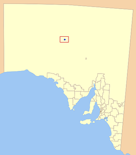
Location of the District Council of Coober Pedy in bluePopulation: 1,913(2009)[1] Established: 1987 Area: 77.8 km² (30.0 sq mi) Mayor: Steve Baines Council Seat: Coober Pedy Region: The Outback State District: Giles Federal Division: Grey 175px The District Council of Coober Pedy is a local government area located around the opal mining town of the same name in Outback South Australia. The district is based around large opal deposits, and has become a major mining town, as well as a popular tourist town.
Contents
History
The town of Coober Pedy was settled entirely for the large finds of opal nearby, with the first deposits uncovered in 1915, before substantially more miners moved in by 1917. The town was named ‘Coober Pedy’ by the local Progress and Miners Association in 1920 from the Aboriginal words "Kupa Piti", meaning white man's hole or waterhole.[2]
With a growing population of over 3000 in 1980, the move was made to establish local government in the area. Although there was some initial controversy, the first elections were held in 1987, signalling the establishment of the council.[2]
Economy
Since the establishment of the town, the district has relied nearly solely on the mining of the gemstone opal. After the initial discovery in 1915, a number of large strikes, particularly in 1946 saw renewed interest, and by the 1960’s, opal mining was a multi million dollar industry, and has remained that way to the present day.[2]
Tourism is a rapidly growing facet of the districts economy, with tourists visiting the area to see the opal mines and the unique underground lifestyle of the town.[3]
Localities
The town of Coober Pedy is the only locality in the district, but the council is not confined exclusively to the town area, and includes the neighbouring opal mining fields.[4]
Elected Members
Mayor: Steve Baines
CEO: Trevor McLeod
Councillors:
- Paul Athanasiadis
- Tina Doulgeris
- Mike Maylin
- Alex Morgan
- Boro Rapaic
- Beverley Staines
- Geoffrey Sykes
- Kevin Woon
References
- ^ Australian Bureau of Statistics (30 March 2010). "Regional Population Growth, Australia, 2008–09". http://www.abs.gov.au/ausstats/abs@.nsf/Latestproducts/3218.0Main%20Features72008-09?opendocument&tabname=Summary&prodno=3218.0&issue=2008-09&num=&view=. Retrieved 3 June 2010.
- ^ a b c Coober Pedy District Council, History, http://www.cooberpedy.sa.gov.au/site/page.cfm?u=112, retrieved 2007-05-30
- ^ Coober Pedy: Opal Capital of Earth, Tourism, http://www.cooberpedy.sa.gov.au/site/page.cfm?u=191, retrieved 2007-05-30
- ^ LGA of South Australia, DC of Coober Pedy, http://www.lga.sa.gov.au/site/page.cfm?c=4159, retrieved 2007-05-30
External links
Local Government Areas of South Australia Metropolitan Adelaide Adelaide · Adelaide Hills · Burnside · Campbelltown · Charles Sturt · Gawler · Holdfast Bay · Marion · Mitcham · Norwood Payneham & St Peters · Onkaparinga · Playford · Port Adelaide Enfield · Prospect · Salisbury · Tea Tree Gully · Unley · Walkerville · West TorrensEyre Peninsula Ceduna · Cleve · Elliston · Franklin Harbour · Kimba · Lower Eyre Peninsula · Port Augusta · Port Lincoln · Streaky Bay · Tumby Bay · Wudinna · WhyallaCentral Barossa · Barunga West · Clare and Gilbert Valleys · Copper Coast · Flinders Ranges · Goyder · Light · Mallala · Mount Remarkable · Northern Areas · Orroroo Carieton · Peterborough · Port Pirie · Wakefield · Yorke PeninsulaSouthern and Hills Murray Mallee Southeast Outback Anangu Pitjantjatjara Yankunytjatjara · Coober Pedy · Maralinga Tjarutja · Nepabunna · Outback Areas Community Development Trust · Roxby Downs · YalataCoordinates: 29°01′00″S 134°45′00″E / 29.0166666667°S 134.75°E
Categories:- Populated places established in 1987
- 1987 establishments in Australia
- Local Government Areas of South Australia
Wikimedia Foundation. 2010.
