- Coober Pedy, South Australia
-
Coober Pedy
South Australia
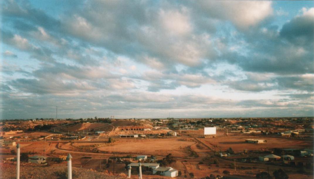
The town of Coober Pedy
 Coober Pedy
Population: 1,916 Established: 1915 Postcode: 5723 Coordinates: 29°0′40″S 134°45′20″E / 29.01111°S 134.75556°ECoordinates: 29°0′40″S 134°45′20″E / 29.01111°S 134.75556°E Location: 846 km (526 mi) from Adelaide LGA: District Council of Coober Pedy Federal Division: Grey Coober Pedy is a town in northern South Australia, 846 kilometres north of Adelaide on the Stuart Highway. According to the 2006 census, its population was 1,916 (1,084 males, 832 females, including 268 indigenous Australians).[1] The town is sometimes referred to as the "opal capital of the world" because of the quantity of precious opals that are mined there. Coober Pedy is renowned for its below-ground residences, called "dugouts", which are built due to the scorching daytime heat. The name 'Coober Pedy' comes from the local Aboriginal term kupa-piti, which means 'white man's hole'.[2]
Contents
Overview
Aboriginal people have a long-standing connection with the area. The first European explorer to pass near the site of Coober Pedy was Scottish born John McDouall Stuart in 1858, but the town was not established until after 1915, when opal was discovered by Willie Hutchison.[3] Miners first moved in around about 1916. By 1999, there were more than 250,000 mine shaft entrances in the area and a law discouraged large-scale mining by allowing each prospector a 165-square-foot (15.3 m2) claim.[4] The harsh summer desert temperatures mean that many residents prefer to live in caves bored into the hillsides ("dugouts"). A standard three-bedroom cave home with lounge, kitchen, and bathroom can be excavated out of the rock in the hillside for a similar price to a house on the surface. It remains at a constant temperature, whereas surface living needs air-conditioning, especially during the summer months, when temperatures often exceed 40 degrees Celsius (104 degrees Fahrenheit). The relative humidity rarely gets over 20% on these hot days, and the skies are usually cloud-free. The average maximum temperature is 30-32 degrees Celsius, but it can get quite cool in the winter.
 Opalized mollusc shell from a Coober Pedy mine. Size: 2.8 x 2.0 x 1.0 cm.
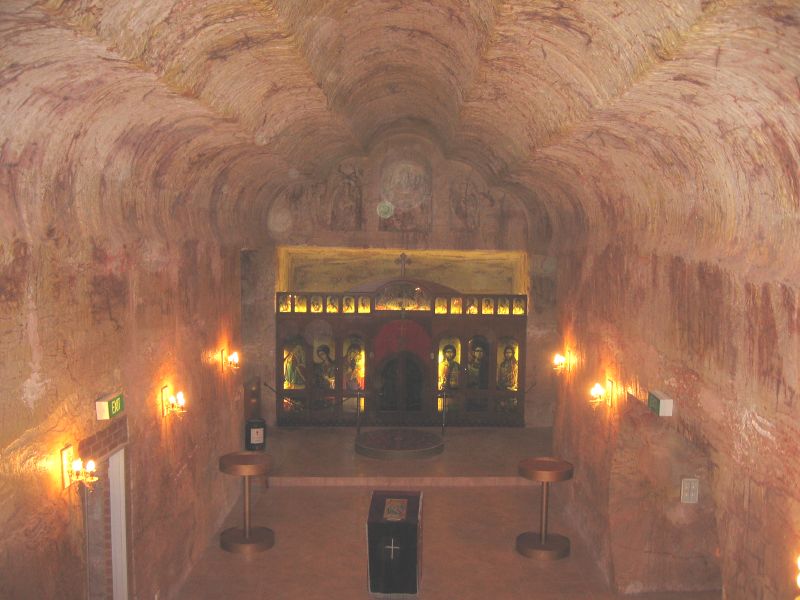
 Underground church
Coober Pedy is a very small town, roughly halfway between Adelaide and Alice Springs, that has become a popular stopover point and tourist destination, especially since the completion of the sealing of the Stuart Highway in 1987.
Interesting attractions in Coober Pedy include the mines, the graveyard, and the underground churches. The first tree ever seen in the town was welded together from scrap iron. It still sits on a hilltop overlooking the town.
Sport and recreation
The local golf course - mostly played at night with glowing balls, to avoid daytime temperatures - is completely free of grass, and golfers take a small piece of "turf" around to use for teeing off. As a result of correspondence between the two clubs, the Coober Pedy golf club is the only club in the world to enjoy reciprocal rights at The Royal and Ancient Golf Club of St Andrews.[5]
The town also has an Australian rules football club, the Coober Pedy Saints, who were created in 2004 and compete in the Woomera & Districts Football League. Due to the town's extreme isolation, to play matches the Saints must make round trips of over 900km to Roxby Downs, where the rest of the league's teams are located.
Climate
Coober Pedy has a desert climate (Köppen climate classification BWh).
Climate data for Coober Pedy Month Jan Feb Mar Apr May Jun Jul Aug Sep Oct Nov Dec Year Record high °C (°F) 47.0
(116.6)46.7
(116.1)44.4
(111.9)40.0
(104.0)33.0
(91.4)29.4
(84.9)32.0
(89.6)35.0
(95.0)39.1
(102.4)43.9
(111.0)45.6
(114.1)47.8
(118.0)47.8
(118.0)Average high °C (°F) 36.4
(97.5)35.7
(96.3)32.8
(91.0)27.6
(81.7)22.3
(72.1)18.8
(65.8)18.7
(65.7)20.7
(69.3)24.5
(76.1)28.9
(84.0)32.1
(89.8)34.6
(94.3)27.8 Average low °C (°F) 20.7
(69.3)20.8
(69.4)18.2
(64.8)14.0
(57.2)10.1
(50.2)7.2
(45.0)6.3
(43.3)7.4
(45.3)10.1
(50.2)13.6
(56.5)16.6
(61.9)19.1
(66.4)13.7 Record low °C (°F) 9.4
(48.9)10.6
(51.1)9.6
(49.3)5.0
(41.0)1.4
(34.5)0.1
(32.2)−2
(28.4)0.6
(33.1)1.7
(35.1)3.9
(39.0)6.7
(44.1)10.0
(50.0)−2
(28.4)Precipitation mm (inches) 17.4
(0.685)22.8
(0.898)12.9
(0.508)6.5
(0.256)13.1
(0.516)14.4
(0.567)7.8
(0.307)9.2
(0.362)8.4
(0.331)14.9
(0.587)11.6
(0.457)17.5
(0.689)156.4
(6.157)Source: Bureau of Meteorology[6] Media
Coober Pedy is served by both local and national radio and television services. The government-owned ABC provides three broadcast radio stations — local radio ABC North & West SA 106.1FM & and the national networks ABC Radio National 107.7FM and Triple J 101.3FM.
Commercial radio stations are Dusty Radio 104.5FM and Flow FM 99.7 <http://www.flowfm.com.au/>. Community radio is provided by indigenous broadcaster Caama Radio 102.9FM.
Four broadcast television services operate in Coober Pedy: commercial stations Imparja Television and Southern Cross Central (formerly known as Seven Central) and the Government-owned ABC and SBS.
Digital Television transmissions are expected to commence sometime between 2010 - 2013. Additional channels that are available in most other areas of Australia are expected to commence transmission in the Coober Pedy area around this time. Analogue television transmissions will be switched off by 31 December 2013.
The local newspaper is the Coober Pedy News which is published weekly, updated and made available (online only) most Wednesdays at http://www.cooberpedynews.com.au/
Transport
The town is served by daily coach services from Adelaide. The Ghan serves the town through the Manguri Siding, 42 km from Coober Pedy, which is served by trains twice weekly in each direction. Passengers on The Ghan are not usually allowed to disembark at Manguri unless they have prearranged transport, due to the siding's isolation and the extremely cold temperatures at night.[7]
Coober Pedy is a gateway to the outback communities of Oodnadatta and William Creek, which are both located on the Oodnadatta Track. There is a twice-a-week mail run from Coober Pedy to these communities and other outback homesteads. It carries the mail, general freight and passengers.[8]
Regional Express also has direct flights to Adelaide, from Coober Pedy Airport.
Preceding Station
(inbound)Service Following Station
(outbound)Marla
(to Darwin)The Ghan Tarcoola
(to Adelaide).
In popular culture
Both the town and its hinterland, for different reasons, are very photogenic and have therefore attracted film makers. The town itself was the setting for the 2006 film Opal Dream. The town is a pivotal location in Wim Wenders' 1991 film Until the End of the World.[9][10]
The hinterland, notably the Breakaways and Moon Plain, have featured as backdrops in films including Mad Max Beyond Thunderdome, Red Planet, Priscilla, Queen of the Desert, Pitch Black and Salute of the Jugger which made considerable use of locals as extras.
Coober Pedy was featured in the second season of the TV series, The Amazing Race.
The book Wildfire by Chris Ryan includes Coober Pedy but states that there are only 3 buildings on the surface and the rest of the town is underground. Much of the 1996 novel Oyster by Janette Turner Hospital, which revolves around opal mining and tells the story of a reclusive self-appointed "messiah", is set in the fictional Outer Maroo, located near Coober Pedy.
The music video for INXS's "Kiss The Dirt (Falling Down the Mountain)" was shot at Moon Plains.
The town was featured on an episode of Sesame Street.
See also
References
- ^ Australian Bureau of Statistics (25 October 2007). "Coober Pedy (State Suburb)". 2006 Census QuickStats. http://www.censusdata.abs.gov.au/ABSNavigation/prenav/LocationSearch?collection=Census&period=2006&areacode=SSC43391&producttype=QuickStats&breadcrumb=PL&action=401. Retrieved 2008-02-28.
- ^ Place Names of South Australia
- ^ Opal Capital of the World
- ^ Smith, R. Australia: Journey Through a Timeless Land. National Geographic Society, 1999. p 118.
- ^ Lane, James M. (2008). Moon Living Abroad in Australia. Berkeley, CA: Seal Press. p. 247. ISBN 978-1-59880-139-2.
- ^ "Coober Pedy". Climate statistics for Australian locations. Bureau of Meteorology. http://www.bom.gov.au/climate/averages/tables/cw_016007.shtml. Retrieved 2009-02-16.
- ^ Great Southern Railway, "Q&A". Retrieved 1 February 2011.
- ^ "The Mail Run Tour". http://www.desertdiversity.com/mail.htm.
- ^ Gluckman, Ron. "Home Under the Range". Ron Gluckman in Cyberspace. http://www.gluckman.com/CooberPedy.Australia.html. Retrieved 2008-12-21.
- ^ "Coober Pedy". RockWalk Park. http://www.rockwalkpark.com/htm2/cooberpedy.htm. Retrieved 2008-12-21.
External links
- Official website from The District Council of Coober Pedy & the Coober Pedy Retail Business & Tourism Association
- Photographs of Coober Pedy in 1994, National Library of Australia
- Coober Pedy
- Travel Channel Video On Coober Pedy
- Coober Pedy photos
- The Mail Run Tour
- Gigapixel Image of The Breakaways, Coober Pedy
- Megapixel Image of Coober Pedy from Stuart Highway
Categories:- Towns in South Australia
- Mining towns in South Australia
- Underground cities
- Australian Aboriginal placenames
- Far North (South Australia)


Wikimedia Foundation. 2010.