- Oodnadatta
-
Oodnadatta
South Australia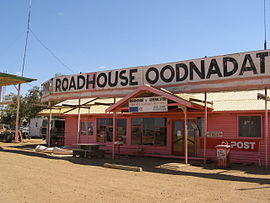
The Pink Roadhouse at Oodnadatta
 Oodnadatta
Population: 277[1] Postcode: 5734 Coordinates: 27°32′S 135°26′E / 27.533°S 135.433°ECoordinates: 27°32′S 135°26′E / 27.533°S 135.433°E Location: - 1034 km (642 mi) N of Adelaide
- 729 km (453 mi) N of Port Augusta
- 189 km (117 mi) NW of Coober Pedy
LGA: Outback Areas Community Development Trust State District: Stuart Federal Division: Grey Oodnadatta, South Australia, is a small town surrounded by an area of 7,800 square kilometres (3,000 sq mi) with cattle stations in arid pastoral rangelands close to the Simpson Desert, 1,011 km (628 mi) north of Adelaide and 112 m above sea level. It can be reached by an unsealed road from Coober Pedy or via the unsealed Oodnadatta Track from Marree to Marla or from the north via Finke, Northern Territory ("Old Ghan Heritage Trail"). The name is derived from Arrernte utnadata, meaning "mulga blossom".[2]
The population was 229 in 1976 and 160 in 1986.[citation needed] The 2006 census reported a population of 277 (150 male, 127 female, including 103 indigenous Australians).[1]
Contents
History
John McDouall Stuart explored the region in 1859. The route mapped by Stuart in his journeys of 1857 to 1862 was adopted as part of the Overland Telegraph Line route. Oodnadatta became the terminus of the Great Northern Railway in 1890,[3] and remained so until the line, which then became known as the Ghan, was extended to Alice Springs in 1929. Oodnadatta busiest era was World War II when Australian Army and Air Force set up local facilities to service troop trains and fighter aircraft en route to Darwin. In 1981 the line was moved to the west, and Oodnadatta, formerly a government service centre and supply depot for surrounding pastoral properties, became a residential freehold town for Indigenous Australians who, moving from cattle work, bought empty houses as railways workers left. Increasing tourist traffic along the Oodnadatta Track and an emerging mining industry keep the village alive. The Aboriginal school is the biggest employer.[2]
Climate
Oodnadatta has a desert climate (Köppen climate classification BWh) and has also recorded the highest reliably measured maximum temperature in Australia: 50.7°C (123.3 F) on 2 January 1960. A higher temperature was recorded at Cloncurry in 1889, however this has since been shown to have been recorded in a non-standard enclosure and likely to have been considerably cooler than first believed.[4]
Climate data for Oodnadatta Month Jan Feb Mar Apr May Jun Jul Aug Sep Oct Nov Dec Year Record high °C (°F) 50.7
(123.3)46.8
(116.2)44.9
(112.8)42.1
(107.8)35.0
(95.0)32.8
(91.0)32.2
(90.0)36.5
(97.7)40.7
(105.3)45.4
(113.7)47.3
(117.1)48.3
(118.9)50.7
(123.3)Average high °C (°F) 37.7
(99.9)36.6
(97.9)33.7
(92.7)28.5
(83.3)23.2
(73.8)19.9
(67.8)19.6
(67.3)22.0
(71.6)26.6
(79.9)30.3
(86.5)33.7
(92.7)36.3
(97.3)29.0 Average low °C (°F) 22.9
(73.2)22.3
(72.1)19.2
(66.6)14.3
(57.7)9.8
(49.6)6.5
(43.7)5.8
(42.4)7.4
(45.3)11.4
(52.5)15.1
(59.2)18.5
(65.3)21.2
(70.2)14.5 Record low °C (°F) 11.7
(53.1)12.8
(55.0)9.5
(49.1)3.8
(38.8)0.9
(33.6)−2.6
(27.3)−2.2
(28.0)−0.3
(31.5)2.2
(36.0)3.4
(38.1)9.6
(49.3)11.4
(52.5)−2.6
(27.3)Precipitation mm (inches) 24.1
(0.949)31.8
(1.252)12.1
(0.476)11.1
(0.437)12.6
(0.496)12.4
(0.488)10.2
(0.402)8.2
(0.323)9.0
(0.354)13.7
(0.539)11.9
(0.469)17.2
(0.677)174.3
(6.862)Source: Bureau of Meteorology[5] Oodnadatta elsewhere
The name Oodnadatta has been used as a name for a crater on the planet Mars[6].
Life in Oodnadatta
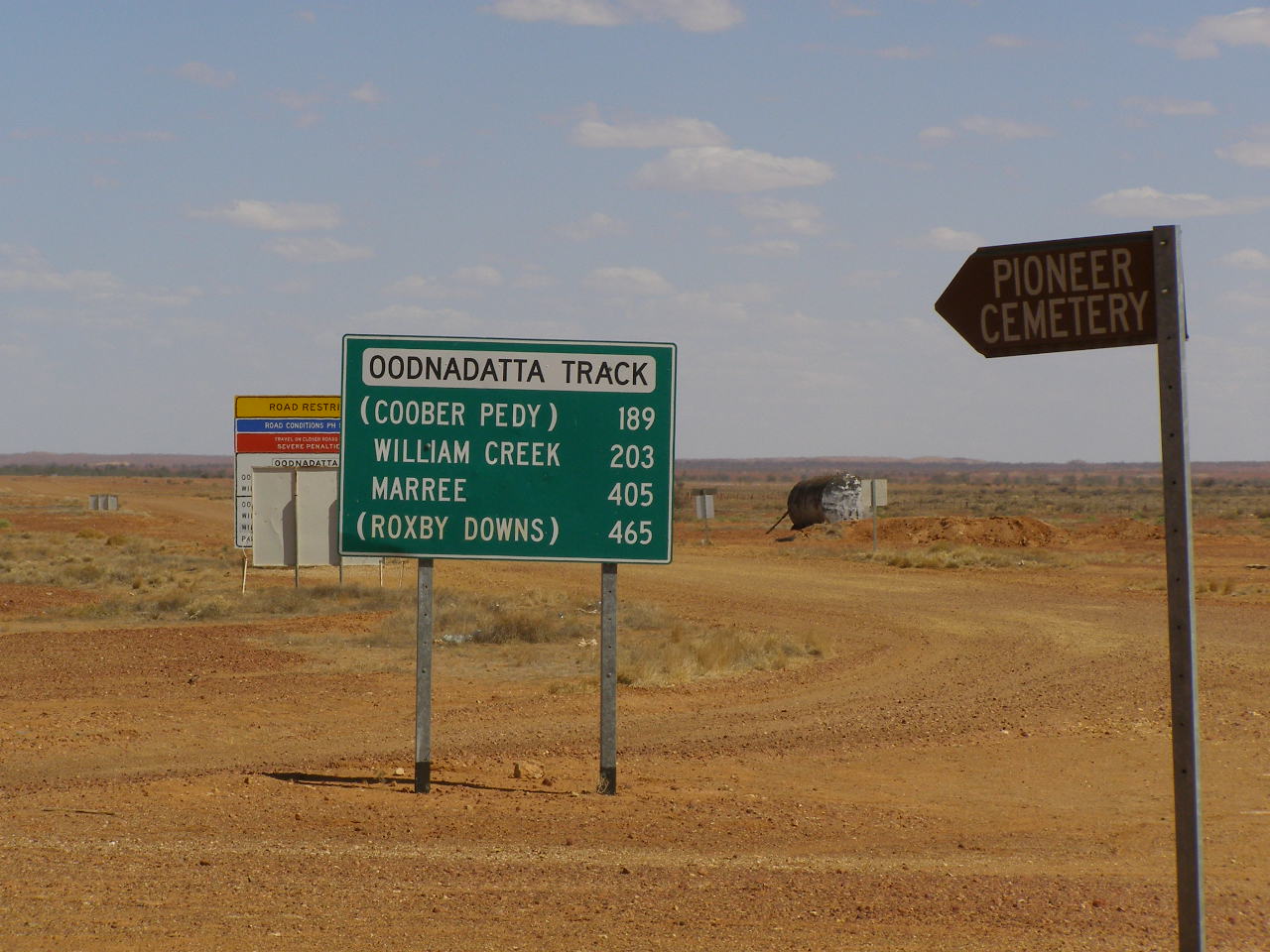
 Oodnadatta Track sign
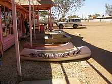 Canoe hire
The Pink Roadhouse (so-called because it is painted bright pink) is a focal point for the town, providing petrol, a general store, meals, post office facilities and canoe hire. Although they really have canoes (also painted bright pink), it is not clear where to use them in the surrounding area unless the local waterholes are recently filled.
Oodnadatta is serviced twice weekly by the Coober Pedy Oodnadatta One Day Mail Run. The OKA mail truck also carries some general freight and passengers.[7] Road trains bring weekly supplies of food and fuel etc from Adelaide. Royal Flying Doctor Service and charter flights use the Oodnadatta Progress Associations' local all weather WW2 airstrip which houses an automatic weather station.
There is a museum in the old Ghan railway station, and a staffed Medical Centre.
References
- ^ a b Australian Bureau of Statistics (25 October 2007). "Oodnadatta (State Suburb)". 2006 Census QuickStats. http://www.censusdata.abs.gov.au/ABSNavigation/prenav/LocationSearch?collection=Census&period=2006&areacode=SSC44476&producttype=QuickStats&breadcrumb=PL&action=401. Retrieved 2008-02-28.
- ^ a b "Outback: The Oodnadatta Track". National Roads and Motorists' Association (NRMA). http://www.mynrma.com.au/cps/rde/xchg/mynrma/hs.xsl/oodnadatta_track.htm. Retrieved 2008-06-24.
- ^ Great Northern to Government Gums - A Mineral Railway Callaghan, W.H. Australian Railway History, September;October, 2008 pp283-301;323-336
- ^ "Queensland to bake on Christmas Day". AM. Australian Broadcasting Corporation. 24 December 2003. http://www.abc.net.au/am/content/2003/s1015670.htm. Retrieved 17 November 2009.
- ^ "Oodnadatta Airport". Climate statistics for Australian locations. Bureau of Meteorology. http://www.bom.gov.au/climate/averages/tables/cw_017043.shtml. Retrieved 2009-06-06.
- ^ Categories for Naming Features on Planets and Satellites, Gazetteer of Planetary Nomenclature, USGS Astrogeology Science Center, NASA
- ^ "Coober Pedy Oodnadatta One Day Mail Run". http://www.desertdiversity.com/mail.htm.
External links
- Tracking History to Oodnadatta by Roderick Eime
- Pink Roadhouse Iconic landmark of Oodnadatta
- Pacific Island Travel
- Oodnadatta Pioneer Cemetery with photos of headstones
- Coober Pedy Oodnadatta One Day Mail Run
Central North West Region East and North East Region Far North Flinders Ranges Gawler Ranges and Far West Ash · Bookabie · Border Village · Coorabie · Fowlers Bay · Gawler Ranges · Iron Knob · Penong · MintabieCategories:- Towns in South Australia
- Aboriginal communities in South Australia
- Far North (South Australia)


Wikimedia Foundation. 2010.