- District Council of Elliston
-
District Council of Elliston
South Australia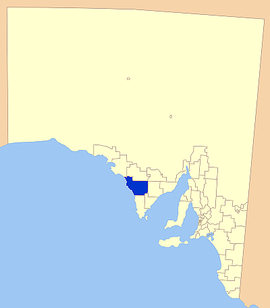
Location of the District Council of EllistonPopulation: 1,169(2009)[1] Established: 1887 Area: 6500 km² (2,509.7 sq mi) Mayor: Pat Clark Council Seat: Elliston Region: Eyre Peninsula State District: Flinders Federal Division: Grey LGAs around District Council of Elliston: District Council of Streaky Bay Wudinna District Council District Council of Kimba District Council of Elliston District Council of Cleve District Council of Lower Eyre Peninsula District Council of Tumby Bay The District Council of Elliston is a Local Government Area covering around 6500 km2 on the Western Eyre Peninsula in South Australia. Established in 1887, the district has a diverse economy, with agriculture, commercial fishing and tourism making up the majority of the local economy.
Contents
Localities
The council underwent boundary alterations in 1989 and the council now encompasses the following main towns:
A number of smaller towns and areas are also encompassed in the district:
Bramfield, Colton, Kopi, McLachlan, Mount Damper, Mount Wedge, Murdinga, Polda, Sheringa, Talia, Tooligie, and Warrachie.
Economy
The district's economy relies on a combination of agriculture and seafood harvesting. Cereal crops and sheep are the main focuses of farming, with abalone and crayfish being important to professional fishermen.
The district has two health facilities; A hospital at Elliston and a medical centre located in Lock. Three schools exist in the district, as well as a community library in Lock. As with most districts on the Eyre Peninsula, there are a variety of sporting clubs and a number of jetties for recreational fishermen.
Elected members
{when|date=July 2011}} Chairman: Pat Clark
Deputy Chairman: Kym Callaghan
Councillors:
- Malcolm Hancock
- Peter Hitchcock
- Creagh McGlasson
- Grant Rumbelow
- Tim Schlink
- Gary White
Senior staff
CEO: Rob Gregor
DCEO: Steve Woolley
Meetings
The Meetings of Council are held on the third Tuesday of each month. Meetings commence at 9.30 am and include a ten minute question time which is open to the public.
External links
References
- Gillman, Dianne. The Custodians. ISBN 0-7316-3363-6.
- ^ Australian Bureau of Statistics (30 March 2010). "Regional Population Growth, Australia, 2008–09". http://www.abs.gov.au/ausstats/abs@.nsf/Latestproducts/3218.0Main%20Features72008-09?opendocument&tabname=Summary&prodno=3218.0&issue=2008-09&num=&view=. Retrieved 4 June 2010.
Towns and Localities of the District Council of Elliston Bramfield · Colton · Elliston · Kopi · Lock · McLachlan · Mount Damper · Mount Wedge · Murdinga · Polda · Port Kenny · Sheringa · Talia · Tooligie · Venus Bay · WarrachieLocal Government Areas of South Australia Metropolitan Adelaide Adelaide · Adelaide Hills · Burnside · Campbelltown · Charles Sturt · Gawler · Holdfast Bay · Marion · Mitcham · Norwood Payneham & St Peters · Onkaparinga · Playford · Port Adelaide Enfield · Prospect · Salisbury · Tea Tree Gully · Unley · Walkerville · West TorrensEyre Peninsula Ceduna · Cleve · Elliston · Franklin Harbour · Kimba · Lower Eyre Peninsula · Port Augusta · Port Lincoln · Streaky Bay · Tumby Bay · Wudinna · WhyallaCentral Barossa · Barunga West · Clare and Gilbert Valleys · Copper Coast · Flinders Ranges · Goyder · Light · Mallala · Mount Remarkable · Northern Areas · Orroroo Carieton · Peterborough · Port Pirie · Wakefield · Yorke PeninsulaSouthern and Hills Murray Mallee Southeast Outback Coordinates: 33°39′00″S 134°53′00″E / 33.65°S 134.883333333°E
Categories:- Populated places established in 1887
- 1887 establishments in Australia
- Local Government Areas of South Australia
- Eyre Peninsula

Wikimedia Foundation. 2010.