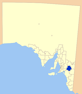
- District Council of Karoonda East Murray
-
District Council of Karoonda East Murray
South Australia
Location of the District Council of Karoonda East MurrayPopulation: 1,193(2009)[1] Established: 1979 Coordinates: 35°01′08″S 140°07′50″E / 35.0188°S 140.1306°ECoordinates: 35°01′08″S 140°07′50″E / 35.0188°S 140.1306°E Area: 4415 km² (1,704.6 sq mi) Mayor: Kevin Burdett Council Seat: Karoonda State District: Electoral district of Hammond Federal Division: Division of Barker 
LGAs around District Council of Karoonda East Murray: Mid Murray Council District Council of Loxton Waikerie District Council of Loxton Waikerie Mid Murray Council District Council of Karoonda East Murray Southern Mallee District Council Rural City of Murray Bridge Coorong District Council Southern Mallee District Council The District Council of Karoonda East Murray is a local government area in the Murray Mallee area of South Australia (35°S 140°E / 35°S 140°E). The main council offices are in Karoonda.
The council area covers 4,415 square kilometres and has a estimated population of 1193.[1] The annual average rainfall is 350 mm.
It is entirely in the state electorate of Hammond and the federal Division of Barker.
Contents
History
In 1979 the District Councils of Karoonda (established 1922) and East Murray (established 1923) amalgamated to form the District Council of Karoonda East Murray. The township of Karoonda was established in 1913 when the mallee railway lines were put in place to open the area to grain growing, as previous pastoral runs had failed.
Townships
Towns in district (including former railway sidings that are now little more than localities): Borrika, Galga, Halidon, Karoonda, Kalyan, Lowaldie, Marama, Mercunda, Mindarie, Mantung, Perponda, Sandalwood, Wanbi, Wynarka.
Neighbours
The neighbouring councils are (clockwise from north):
- District Council of Loxton Waikerie
- Southern Mallee District Council
- Coorong District Council
- Rural City of Murray Bridge
- Mid Murray Council
References
- ^ a b Australian Bureau of Statistics (30 March 2010). "Regional Population Growth, Australia, 2008–09". http://www.abs.gov.au/ausstats/abs@.nsf/Latestproducts/3218.0Main%20Features72008-09?opendocument&tabname=Summary&prodno=3218.0&issue=2008-09&num=&view=. Retrieved 3 June 2010.
External links
Local Government Areas of South Australia Metropolitan Adelaide Adelaide · Adelaide Hills · Burnside · Campbelltown · Charles Sturt · Gawler · Holdfast Bay · Marion · Mitcham · Norwood Payneham & St Peters · Onkaparinga · Playford · Port Adelaide Enfield · Prospect · Salisbury · Tea Tree Gully · Unley · Walkerville · West TorrensEyre Peninsula Ceduna · Cleve · Elliston · Franklin Harbour · Kimba · Lower Eyre Peninsula · Port Augusta · Port Lincoln · Streaky Bay · Tumby Bay · Wudinna · WhyallaCentral Barossa · Barunga West · Clare and Gilbert Valleys · Copper Coast · Flinders Ranges · Goyder · Light · Mallala · Mount Remarkable · Northern Areas · Orroroo Carieton · Peterborough · Port Pirie · Wakefield · Yorke PeninsulaSouthern and Hills Murray Mallee Berri Barmera · The Coorong · Gerard · Karoonda East Murray · Loxton Waikerie · Mid Murray · Murray Bridge · Renmark Paringa · Southern MalleeSoutheast Outback Categories:- Populated places established in 1979
- 1979 establishments in Australia
- Local Government Areas of South Australia
Wikimedia Foundation. 2010.
