- District Council of Franklin Harbour
-
District Council of Franklin Harbour
South Australia
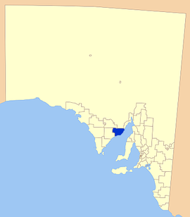
Location of the District Council of Franklin HarbourPopulation: 1,355(2009)[1] Established: 1888 Area: 3283 km² (1,267.6 sq mi) Mayor: Eddie Elleway Council Seat: Cowell Region: NE Eyre Peninsula State District: Flinders Federal Division: Grey 
LGAs around District Council of Franklin Harbour: District Council of Kimba Outback Areas Community Development Trust City of Whyalla District Council of Cleve District Council of Franklin Harbour The District Council of Franklin Harbour is a Local Government Area in South Australia located on the Eyre Peninsula. Cowell is the major population centre of an agricultural district based on farming wheat and sheep, supplemented by a fishing and oyster farming industries. The district's coastal towns including Cowell and Lucky Bay attract large amounts of tourists during school holidays, with the new Spencer Gulf ferry service increasing traffic to theses areas since 2006.[2]
Contents
History
Franklin Harbour itself was first sighted by Matthew Flinders in 1802 and subsequently named after his midshipman, Sir John Franklin, by Governor George Gawler in 1840.
The first settlers to the region arrived in 1853, with more following soon afterward. This led to the establishment of the District Council of Franklin Harbour in 1888, making it one of the older districts on the Eyre Peninsula.[3]
Localities
Cowell is the regions major town, but a number of smaller towns and more isolated localities are encompassed in the district. These include:
Carpa, Charleston, Coolanie, Elbow Hill, Franklin Harbour, Glynn, Hawker, Heggaton, James, Lucky Bay, Mangalo, McGregor, Midurnie, Miltalie, Miltalie North, Minbrie, Mitchellville, Mount Millar, Playford, Point Gibbon, Port Gibbon, Pondooma, Utera, Warren, Wilton and Yabmana.[4]
Facilities
The town of Cowell has most of the normal facilities of a larger town including accommodation, supermarket, petrol station, hotel and a number of food supplying shops.
Educationally, Cowell has an area school and a library; with a district hospital and clinic to cover the area's health needs. A number of churches also serve the district.
There are a number of sporting clubs including cricket, football, netball, golf and bowls along with playing facilities for each sport. Cowell also has an all weather boat ramp for those with boats, as well as a jetty.[5]
Elected Members
Mayor: Eddie Elleway
CEO: Bruce Francis
Councillors:
- Frank Wildman
- Allan Zerna
- Gavin Jackson
- Tony Kaden
- Robert Udy
Meetings of the District Council of Franklin Harbour occur at 11.00am on the second Wednesday of each month, with the meetings open to the public to observe, unless prior notice is given to the contrary.
References
- ^ Australian Bureau of Statistics (30 March 2010). "Regional Population Growth, Australia, 2008–09". http://www.abs.gov.au/ausstats/abs@.nsf/Latestproducts/3218.0Main%20Features72008-09?opendocument&tabname=Summary&prodno=3218.0&issue=2008-09&num=&view=. Retrieved 4 June 2010.
- ^ Sea SA, Timetable, http://www.seasa.com.au/, retrieved 2007-05-18
- ^ District Council of Franklin Harbour, History, http://www.franklinharbour.sa.gov.au/site/page.cfm?u=128, retrieved 2007-05-18
- ^ Local Government of SA Association, LGA Website DC of Franklin Harbour, http://www.lga.sa.gov.au/site/page.cfm?c=4162 LGA Website, retrieved 2007-05-18
- ^ District Council of Franklin Harbour, General information, http://www.franklinharbour.sa.gov.au/site/page.cfm?u=123, retrieved 2007-05-18
External links
Towns and localities of the District Council of Franklin Harbour Carpa · Charleston · Coolanie · Cowell · Elbow Hill · Franklin Harbour · Glynn · Hawker · Heggaton · James · Lucky Bay · Mangalo · McGregor · Midurnie · Miltalie · Miltalie North · Minbrie · Mitchellville · Mount Millar · Playford · Port Gibbon · Pondooma · Utera · Warren · Wilton · YabmanaLocal Government Areas of South Australia Metropolitan Adelaide Adelaide · Adelaide Hills · Burnside · Campbelltown · Charles Sturt · Gawler · Holdfast Bay · Marion · Mitcham · Norwood Payneham & St Peters · Onkaparinga · Playford · Port Adelaide Enfield · Prospect · Salisbury · Tea Tree Gully · Unley · Walkerville · West TorrensEyre Peninsula Ceduna · Cleve · Elliston · Franklin Harbour · Kimba · Lower Eyre Peninsula · Port Augusta · Port Lincoln · Streaky Bay · Tumby Bay · Wudinna · WhyallaCentral Barossa · Barunga West · Clare and Gilbert Valleys · Copper Coast · Flinders Ranges · Goyder · Light · Mallala · Mount Remarkable · Northern Areas · Orroroo Carieton · Peterborough · Port Pirie · Wakefield · Yorke PeninsulaSouthern and Hills Murray Mallee Southeast Outback Coordinates: 33°41′00″S 136°56′00″E / 33.6833333333°S 136.933333333°E
Categories:- Populated places established in 1888
- 1888 establishments in Australia
- Local Government Areas of South Australia
- Eyre Peninsula
Wikimedia Foundation. 2010.
